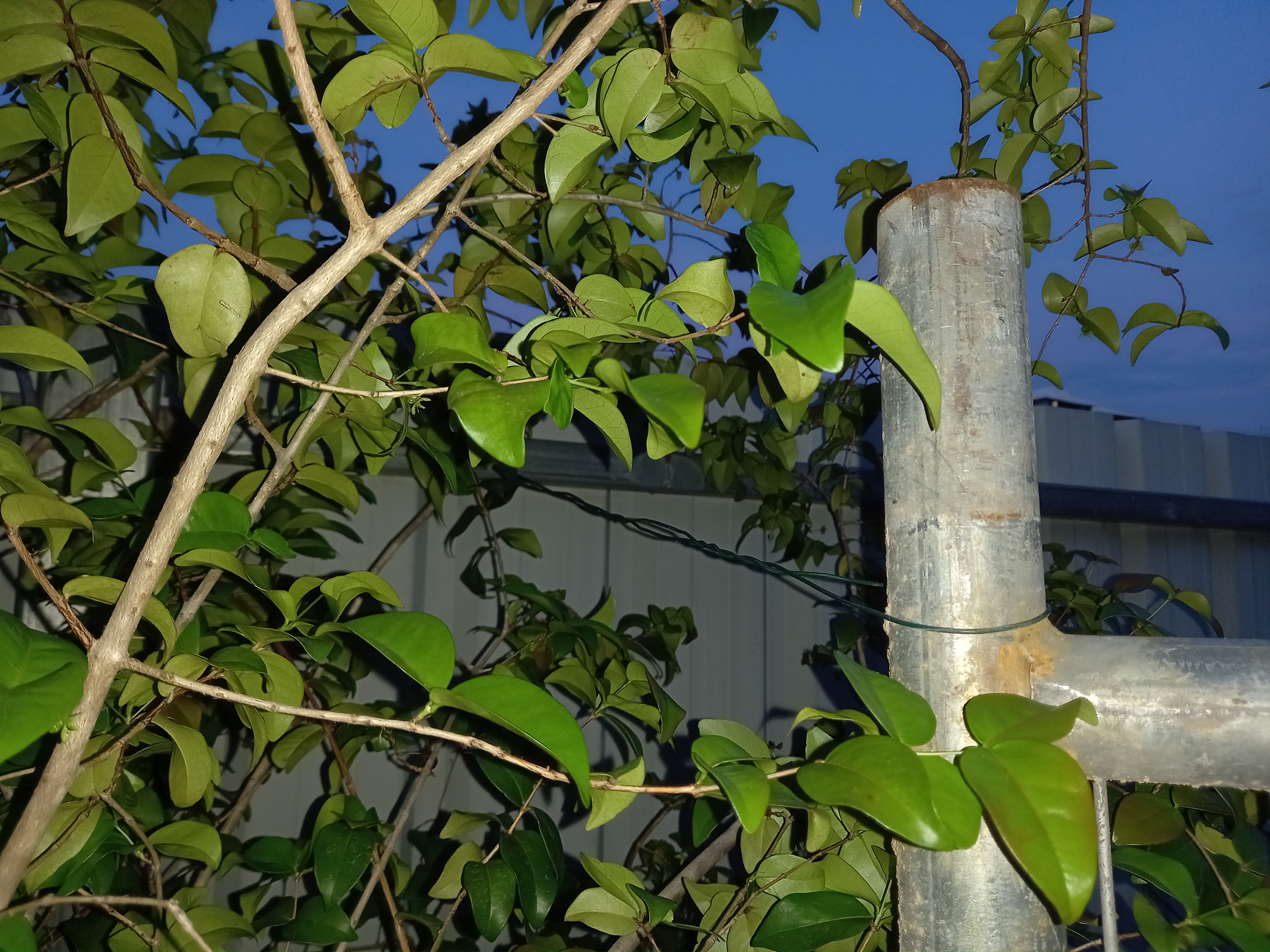
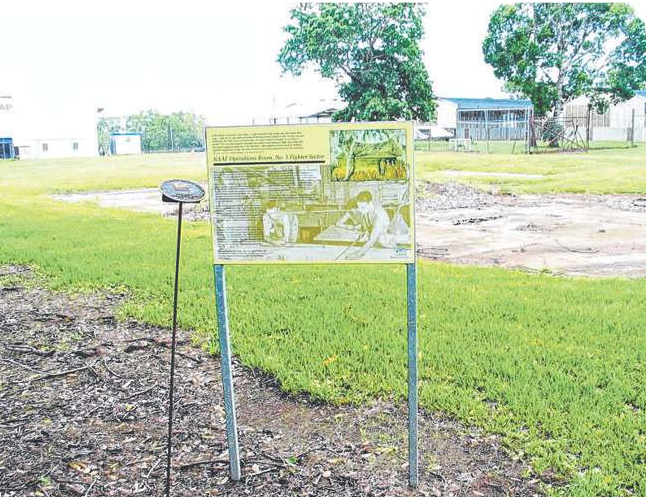
A former employee of the Berrimah Farm field research facility says he is "staggered" the developer that was controversially gifted the land has not maintained public access to a heritage-listed World War II site that played a vital role in the defence of northern Australia. Rob Wesley, who worked at Berrimah Farm when it was the beating heart of the former Department of Primary Industry and Fisheries (DPIF), said he was left fuming when he attempted to access the World War II RAAF Operations Room Site only to be greeted by an inaccessible gate. "An important, but maybe less well-known, World War II site is not accessible, and who knows what damage/maintenance is being done?" he said. Mr Wesley took his concerns to the NT Government's Heritage Branch, which told him that, as the declared heritage site is on private land, there is no obligation for the land owner, Halikos Group, to provide public access. A representative of the branch told Mr Wesley he would need to follow up with Halikos to negotiate access. Mr Wesley said such a system ran directly counter to the spirit of what the purpose of heritage-listing was: to preserve worthy buildings and sites for the enjoyment of future generations. "I'm staggered that heritage sites on private land are limited to what the private landowners allow," he said. "This to my mind makes a bit of a mockery of the term, or my concept of what it means. "The land was given to the housing company- but did this gift not require maintenance and access to this World War II site of importance? "If not, what a fiasco.
"Does Halikos now control access to the DPIF site? "Why not give them Parliament House as well." Halikos acquired the Berrimah Farm land in 2016 after the 168ha site was controversially gifted to the developer, despite another group offering the NT government $3om for the property. It is now in the process of being developed into up to 1500 residential lots alongside a retail precinct and community open space. Halikos Group, who was asked whether access to the World War II site will eventually be restored, did not respond to requests for comment. According to the site's heritage listing, the Operations Room provided "a co ordinating role for the control of aerial defences, including Radio Direction Finding [RDF] and anti-aircraft defences in the North Western Area of Operations in the north of Australia during World War II".
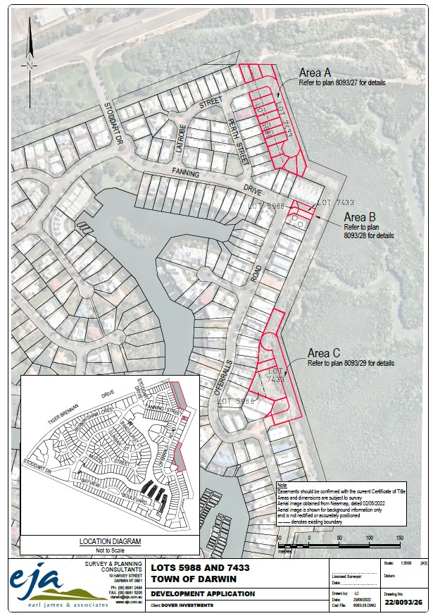
There is a current Planning Notices/Development Applications NT further application by Earl James and Associates to develop land at Bayview.
It includes a proposed rezoning of some land. Total to create 19 lots.
The application is similar to the previous one using marginal land, but adding a proposed rezoning of some currently FD (Future Development) land as well.
Here is the reference number to the full proposal: PA 2023/0327 Concurrent Application. Dates for submissions 8 March to 5th April, 2024.
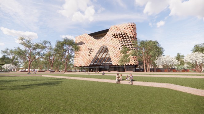
A first look at the National Aboriginal Art Gallery is available
MASTERPLAN SA PTY LTD Proposed Development: Exhibition Centre with Ancillary Place of Assembly
PA2024/0053 has an exhibition period of Friday, 8 March 2024 - Midnight Friday, 5 April 2024 when it has been placed on public display this morning 22/3/24, PLan are following up.
Submission Writing Guide – URO application for a mineral exploration licence EL33285
Submissions due before 7 October 2022 by emailing This email address is being protected from spambots. You need JavaScript enabled to view it.
Summary
On 7 September 2022 URO Corporation Pty Ltd advertised in the NT News notification of their application for a minerals exploration licence covering 299km2 of land adjacent to Litchfield National Park (see above map). The application states that URO Corporation will explore for uranium, lithium, rare earth metals and precious metals. However the significant target of their exploration is uranium with drilling planned in year two of the exploration licence, if it is approved. We believe that the environmental, social, cultural, and recreational values of Litchfield National Park and the Litchfield-Finnis region are seriously threatened by this proposal and that the public should be fully informed about the potential impacts. We know that the residents of Darwin, Palmerston, Litchfield-Finniss and other areas of the Northern Territory and want to see Litchfield National Park and the Litchfield-Finniss region remain safe and healthy for the decades to come.
What is involved in URO Corporation’s application for mineral exploration licence EL33285?
The proponent of the exploration application EL33285 is URO Corporation Pty Ltd.
The mineral exploration licence EL33285 proposal involves the possible exploration of approximately 299km2 of land in the Litchfield-Finniss region adjacent to Litchfield National Park near Wangi Falls (see blue outlined area on map) over a period of six years, including clearing land and drilling for uranium. During exploratory drilling for uranium the environment and waterways could be exposed to toxic contaminants. Any contamination would need to be managed and possibly removed from the site which would include being transported through Litchfield National Park.
What are the problems with the project?
Exploration for uranium can threaten human health
The possible clearing of land for exploratory drilling will destroy wildlife habitat
Tourism and local business can be negatively affected
Cultural sites may be affected
Possible contamination of land and waterways from Litchfield National Park to Channel Point through seasonal flooding
What should I include in my submission?
The most important thing to convey in your submission is your concern about possible negative impacts of the proposed exploratory licence and your interest in seeing the environmental, cultural, social, and recreational values of Litchfield National Park, the Litchfield-Finnis region and Channel Point protected. It is powerful to discuss the issues that are relevant to you through your recreational, professional, or cultural connection to the area. We need to demand transparency and accountability and ensure that the public are fully informed about the toxic activity planned for the Litchfield-Finnis region.
More points and wording for a submission can be found in the Protect the Litchfield-Finniss region from uranium & lithium mining petition on Change.org at https://chng.it/QWf92Tx5 and in the example submission letter on the following pages.
How do I make a submission?
Submissions are due to the Mineral Titles office before 7 October 2022 by emailing This email address is being protected from spambots. You need JavaScript enabled to view it.
Could you include the This email address is being protected from spambots. You need JavaScript enabled to view it. in your emailed submission?
Is there anyone I can ask for help about writing the submission?
Laura Cusack can answer questions you have about the submission. This email address is being protected from spambots. You need JavaScript enabled to view it.
Your Name
Address Line 1
Address Line 2
Date Month Year eg 26 September 2022
Mineral Titles
Department of Industry, Tourism and Trade
By email: This email address is being protected from spambots. You need JavaScript enabled to view it.
Dear Minister
URO Corporation Pty Ltd application for the grant of a mineral title EL33285
I am writing about URO Corporation’s application for the grant of a mineral title to explore for uranium and lithium on 299km of land in the Litchfield-Finniss region advertised on 7 September 2022 in the NT News.
[Write about who you are and how this proposal affects you] My partner and I are land owners of 20 acres of land in the proposed exploration area. We grow our own organic food and the creeks that flow through the area are our only water source for drinking and watering food crops, therefore we are directly affected by URO’s mineral title application, particularly if there is exploration for uranium and lithium by drilling.
I believe the licence should be rejected on the following grounds:
[List all points that are important to you. Additional points can be found in the petition at https://chng.it/QWf92Tx5]
Mineral exploration, especially drilling for uranium which URO Corporation states will be their significant target, could negatively impact the environment and the creek and river systems in the area which are water sources for local flora and fauna as well as the only water source for residents who live in the area. The University of New South Wales’ Global Water Institute and the Environment Centre of the Northern Territory (ECNT) undertook a longitudinal assessment of the publicly available information on water related issues at Glencore’s McArthur River Mine over the period 2007 – 2018. The study analysis shows repeated failures on behalf of the mine site Operator and Mining Regulator to act in a timely manner to address risks to sensitive aquatic environments and has resulted in unacceptable risks to the Northern Territory environment and the downstream community of Borroloola. In 2014 the mine’s leaky tailings dam was found to be at risk of collapse and due to the leakage, high levels of lead were found in local fish stocks and 400 cattle had to be destroyed after the Department of Mines and Energy found cattle contaminated with lead after they drank from a contaminated creek (ECNT, date unknown). The water related issue at the McArthur River Mine is just one example of how the Northern Territory Government and mining companies are unable to respond adequately to protect water sources from contamination by uranium. The Rum Jungle tailing dam leakage and dam wall collapse, is another example where the Finniss river was contaminated with devastating results. We do not want to see this devastating environmental, water and business damage to occur again in the Litchfield-Finniss region.
The proposed mineral exploration area is dangerously close to Litchfield Park’s Wangi and Cascade Falls, situated within the Litchfield National Park tourist precinct, which are Koongurrukun people’s cultural sites that require respecting and protecting by the Northern Territory Government.
Litchfield National Park and the proposed exploration area have also been identified as home to 21 threatened species including the critically endangered Curlew Sandpiper, Eastern Curlew and Far Eastern Curlew as well as the endangered Australian Painted Snipe, Black-footed Tree-rat, Northern Quoll, and the Gouldian Finch. Allowing mineral exploration, especially for uranium, in the area will disturb and potentially destroy the habitat of these threatened species.
There is also the prevalence of Gamba grass (Andropogon gayanus) in the proposed exploration area. Gamba grass is a highly invasive weed that is extremely harmful to the Northern Territory's natural environment. The grass seed is spread many ways including on the wheels of vehicles. Recent news reports have stated the large number of fires in the Litchfield and nearby Adelaide River areas over the recent months have been fueled by the prevalence of Gamba grass. There is grave concern that mineral exploration and mining in the proposed exploration area would create potential spread of Gamba grass through Litchfield National Park and other areas in the region via heavy vehicle movement between properties in the area, Aboriginal land, Litchfield National Park and sale destination.
Landowners in the proposed area operate tourism and accommodation businesses as well as cattle stations that could be negatively impacted by the approval of the exploration licence for uranium and lithium, in particular. Landowners and residents also grow their own food crops. URO Corporation and any company granted a mining exploration licence in the Northern Territory is under no obligation to assess any possible impact or substantial disturbance to landowners and residents’ income, livestock, business, assets or ability to grow food on the land which may have taken many years and significant investment to establish.
The proposed exploration area borders Litchfield National Park on one side and the Aboriginal lands of the Wadjigan and Kiuk people, and the Channel Point Coastal Reserve on the other. The Channel Point region is home to the Peron Island, Bulgul community and Channel Point community. The area, including the Peron Islands, is a protected coastal habitat that is an identified area of international conservation significance and home to threatened and significant fauna. The area is also an important tourism area via a permit system as well as facilitating numerous fishing charters. The proposed exploration area is home to a network of river systems that are a part of the Daly Basin, including the Anton Bay and associated coastal floodplains which connect with the mouth of the Daly River and flows into Wadjigan and Kiuk lands and the Channel Point area. Any contamination from wastewater overflow in the proposed exploration area could spill into these interconnected river systems via floodplains in the wet season and have a potentially devastating effect on a pristine environment in the Channel Point area, one of the most fertile fishing grounds in the Northern Territory.
With local waterways so interconnected and multiple biodiverse areas, protected habitat, flora and fauna connected to these waterways as well as these waterways providing the only accessible drinking and crop water in the area, this is a situational context that should be seriously considered in assessing this mineral exploration application.
We are very concerned by the prospect of increased heavy vehicle movements between properties in the area, Aboriginal land, Litchfield National Park and sale destination due to the damage these vehicles can cause.
We are extremely concerned about the methods involved in uranium and lithium exploration and mining and their environmental impacts. We understand that the methods used can be extremely damaging to the environment, water intensive with billions of litres of contaminated water to dispose of and involve a form of strip mining for pegmatite which occurs throughout the region, as well as blasting, crushing and processing using toxic chemicals. We need look no further than the legacy of the Rum Jungle mine in the Litchfield/Batchelor area for evidence of the damage of government approved uranium mining. Following the collapse of the mine’s tailing’s dam, 100 km2 of the Finniss River system was polluted killing all plant and animal life for a 10 kilometre stretch of the river (Senate Select Committee on Uranium Mining and Milling, 1997). To this day, 50 years since it closed, the Rum Jungle mine site continues to leave a legacy of environmental damage so severe that it will cost hundreds of millions of tax payers’ dollars to rehabilitate the site over decades (ABC News, 2021). The Northern Territory Government has an obligation to never allow this gross environmental destruction to occur again in the region.
The Senate Select Committee on Uranium Mining and Milling report published by the Australian Government in 1997 found that uranium mines, including Rum Jungle, cause serious environmental damage through acid mine drainage in terms of tailings waste, production and mining processes. Tailings from uranium mining contain 80% of the level of radioactivity of the original ore as a result of the presence of uranium decay products such as Thorium 230, Thorium 234 and Radium 226. The environmental impacts of tailings have been well documented for uranium mines including the Roxby Downs and Ranger uranium mines, as well as Radium Hill and Rum Jungle. (Senate Select Committee, 1997).
We have no faith that the Department of Industry, Trade and Tourism (the Department) will appropriately monitor and regulate the activities of URO Corporation. Section 66 (2) under the Mineral Titles Act states that “no later than 14 days after lodging an application for the grant of a mineral title, the applicant must serve a notice of the making of the application on each landowner listed in the application.” In the case of EL33285, URO Corporation did not serve notice to landowners in the area within this timeframe. Notices were served by URO Corporation to landowners nine months after the application was submitted, two weeks before URO Corporation advertised the application for the granting of a mineral exploration licence. Notifying landowners so late after the application was submitted left landowners in the area very little time to prepare submissions which are due, under the Mineral Titles Act, within 30 days of the application being advertised. Landowners and other stakeholders in the area have been severely disadvantaged by this action undertaken by URO Corporation. When the Mineral Titles Office (the Office) were contacted by phone about the notification timeframe they stated that they have no way of knowing if applicants have actually served notifications to landholders within the requirement of the Mineral Titles Act. It appears the Office does not have appropriate processes in place to ensure applicants are following the required regulations. This becomes increasingly important given that under section 58 (2)(b) of the Mineral Titles Act “the applicant must have complied with requirements under this Act” and under section 70 (2) “If the Minister is satisfied the applicant has not met the necessary criteria for the application, the Minister may refuse the application.”
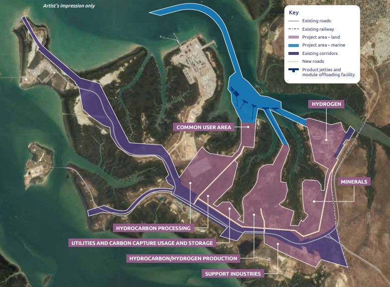
The Department of Infrastructure, Planning and Logistics (DIPL) is seeking environmental approval for a ‘development ready’ industrial precinct on the Middle Arm peninsula. If approved, it may include low emission hydrocarbons, renewable hydrogen, minerals processing, carbon capture and storage and advanced manufacturing. The precinct would cover approximately 1500 hectares of the 2200-hectare Middle Arm peninsula, in an area designated for gas-based, low emissions sustainable industries. Middle Arm is already home to the Santos Darwin LNG Project at Wickham Point, and the INPEX LNG Project at Bladin Point.
Strategic assessments should provide greater upfront certainty for developers while also delivering better environmental outcomes for the significant environmental values at Middle Arm and the broader Darwin Harbour.
The MASDP referral is the first ‘strategic assessment’ in the Northern Territory.
The NT EPA invites public comment on a proposed Program to establish an industrial precinct on Middle Arm Peninsula, Darwin Harbour, here ntepa.nt.gov.au/consultation/open-consultations (this is another useless link)
You can make a submission by emailingThis email address is being protected from spambots. You need JavaScript enabled to view it.
You must sign your uploaded submission to ensure that it is valid under the Planning Act. A valid signed submission includes a hand-signed document that is scanned and/or photographed;a name typed at the bottom of an email or uploaded document; or a JPG (or similar) of a signature placed at the bottom of the email or uploaded document.
Contact your Local Member, the three City of Darwin Alderman and the Planning Minister. Should community be involved in planning decisions?/
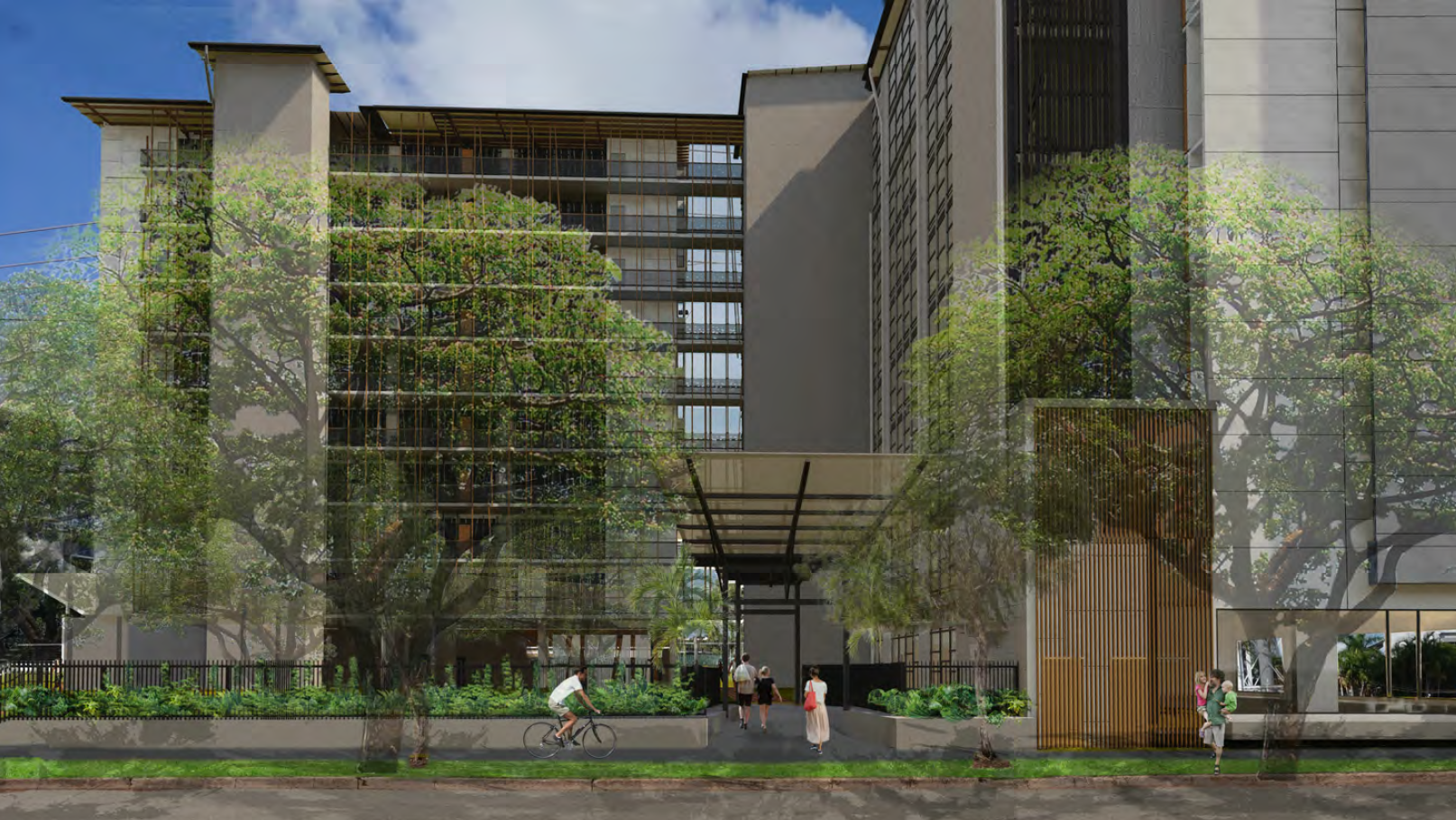
Exhibition Period: Friday, 9 September 2022 - Midnight Friday, 7 October 2022 Address: Lot 01287 Town of Darwin 1 MONTORO CT LARRAKEYAH Lot 01288 Town of Darwin 2 MONTORO CT LARRAKEYAH Lot 01295 Town of Darwin 8 PACKARD PL LARRAKEYAH Lot 01296 Town of Darwin 7 PACKARD PL LARRAKEYAH Current Zones: TC (Tourist Commercial) Proposed Development: 44 dwellings-multiple and 47 serviced apartments in two 10-storey buildings plus ground level food premises-cafe/takeaway with alfresco dining area and three basement levels of car parking. Requested Variations: Setbacks
Generally, some of the surrounding buildings are 8 story, these proposed buildings are not cohesive with existing buildings.
The owners of this site have carried out remedial works with almost no consultation with community, including works commencing with no builder identified.
Multiple complaints have been placed with work safe due to gates being left open and the site not being kept secure. For many years there has been water in the pit.
Works are carried out with no safety signage.
The site was originally low height. Community has an expectation of existing views being retained.
This project is impact assessable.
The location is close to MD and SD
The applicant refers to planning history then recognizes that planning history cannot be used in this application
All traffic will be directed through Montoro Court and Packard Place with no consultation with the community
There is a large void in the project and the proponent has a track record of trying to maximise the footprint
The proponent claims to minimize impact on the local area. P13
The applicant describes the building heights as compatible with adjacent locations yet on at least two sides the towers will dominate.
The applicant claims Smith street will not be affected while introducing hundreds of cars through the considerably congested Smith Street intersections. P17 the claim is here of high amenity to the public realm. What is the basis of this statement?
The café claims to service tourism.
Many serviced apartments in Darwin have been returned to the residential pool.
P18 the claim is here that the development minimizes unreasonable impacts to the amenity of surrounding premises. What proof is given.
P18 the applicant refers to multiple 9 story buildings adjacent, clearly not true? P18
The claim that the building will be a positive character addition to the area is opinion only. P19
The disadvantage of having our homes overlooked by these units is not addressed.
The applicant claims to minimize any unreasonable amenity impacts, on what basis? Has community been consulted? P19
The claim that previous traffic studies and that traffic has not changed since 2015 does not bear scrutiny. There appears to be only the applicant’s assertion that all is ok on traffic.
There is no garden to Montoro Court.
Three bedroom serviced apartments only require one car park. This is a planning error, see Tipperary.
P 23 mention of vehicle sites lines not being an issue, where is the traffic study?
No tree planting on Montoro Court
What guarantees are provided that landscaping will be maintained for the life of the building. Refer to very poor condition of the location for many years.
Smith Street setback is non compliant and the applicant again refers to a previous approval which is irrelevant. This will lead to massing over Smith Street. The purpose of the Smith Street setback was to provide continuous views and recent planning approvals are degrading this feature, diminishing the amenity of the area. P32
Set backs are dealt with as if two buildings yet the buildings are connected.
Set back to Montoro Court does not comply
Set backs to the rear of the building do not comply.
Again many setbacks do not comply at all. Why have a planning scheme?
The proponent then brings in NTCAT. The community has an expectation that planning legislation will protect the community from opportunism.
Again, reliance on previous approvals which are irrelevant.
The application takes advantage of being two buildings in one argument (set backs) then as one building from the point of view of distance between the building, this value is not discussed. P40
18 units have a reduce verandah size. The applicant proposes there is no need to following planning regulations here as not many people will be in the one bedroom units.
P 45 no addressing the requirement to minimize unreasonable impacts on the privacy and amenity of surrounding residents.
This is closing on the 15th of April 2022. Please return to this page as we will be updating over the next few days.
PROPOSAL TO AMEND NT PLANNING SCHEME PA2022/0011 PROPOSAL TO AMEND THE NT PLANNING SCHEME 2020 TO INCLUDE THE HOLTZE TO ELIZABETH RIVER SUBREGIONAL LAND USE PLAN AS A POLICY DOCUMENT AND CONSEQUENTIAL UPDATES TO THE LITCHFIELD SUBREGIONAL LAND USE PLAN AND DARWIN REGIONAL LAND USE PLAN.
We have reviewed the documents provided as part of the proposed amendment and have provided the following summary of our concerns:
Areas such as the natural catchments, which are prone to constraints such as flooding, should exclude any residential development in these areas. It would be unnecessary for residential development to occur, only for this community to be subjected to damage and/or destruction as a result of known area flooding.
We are concerned that in the absence of a Regional Conservation Strategy, development will occur which will impact upon natural environments and areas of environmental value.
We support the identification of paperback swamp, east Tiger Brennan Drive/ Tivendale Road as a conservation area and believe this status should remain unchanged.
We are concerned of mention that “…property along the Stuart Highway will become increasingly attractive for commercial uses…” (p. 22) and as a result, will have potential impact upon current green space.
We are concerned that the Howard Springs North Investigation area, south of the Main Road and part of the Howard Springs North (Pine Forest), will ultimately encroach and impact upon the Howard Springs Nature Park.
We are concerned that “…the (former) Commonwealth Defence establishment land ‘Kowandi North’ (Kowandi), and conterminous Crown land to the north and east creates the potential for approximately 5000 dwellings to be developed in the near to mid-term through staged land releases” (p. 24). As a result, this will impact upon the ‘open space’ and/or ‘conservation’ site area.
We support mention that “any future land use change across the Howard Springs North area should consider the potential of retained natural areas to support both organised and passive recreation” (p. 26). The Northern Territory should retain as much natural area for community benefit and use and should not be subject to development.
We are concerned of mention that “…a large part of Virginia South-West is constrained by either soil waterlogging, storm surge, or exposure to biting insects” (p. 28). Given that the area is prone to storm surge, future development of the area would be inappropriate. It would be unnecessary for residential development to occur, only for the community to be subjected to damage and/or destruction as a result of known storm surge issues.
Previously the accepted distance was 1.5km for biting insects. Nick Note
We are concerned about mention of future development in the Archer and Mitchell West Focus Area. As the proposed planning scheme amendment document mentions, “(b)oth areas are affected by seasonal waterlogging and storm surge” (p. 30). As mentioned previously, given that the area is prone to storm surge, future development of the area would be inappropriate. It would be unnecessary for development to occur, only for the community to be subjected to damage and/or destruction as a result of known storm surge issues.
RALLY - Public Meeting Thursday 9th February 5:30pm at Latrobe Park, all welcome.
In a Darwin wet season application, two poorly placed pink signs have appeared in Bayview. Residents have been given 2 weeks to comment on the rezoning to create an additional 21 lots mostly in the sub 500sqm size.
Now that there is no public advertising of Development Applications, community are required to access a government website to learn of this and similar applications.
The department has agreed to extend the exhibition process. BUT community are required to request the extension individually.
If you are concerned in this lack of equity, please send an email to:
This email address is being protected from spambots. You need JavaScript enabled to view it.
Request for extension for submission to PA2022/0474, Bayview
This application is my personal request for an extension of time for me to make a submission in relation to application PA2022/0474, Subdivision - Bayview, due at midnight 3/2/2023.
Why has no referral to the EPA occurred given the proximity to Rapid Creek.
A significant change from grassed open space to solid foundations will occur if this development is approved.
How many community members submitted on the rezoning?
Will the Sound Barrier wall to McMillans Road be maintained in good order? Lee Point and other locations show that there is no guarantee of upkeep of these walls.
The small blocks are 400sqm and if all blocks are developed to capacity the maximum number of dwellings able to be accommodated in the proposed subdivision is 98 dwellings
Battern Road - At this stage, the future connection to Batten Road is not resolved, and will be done so as part of a future application for stage 2 of the subdivision.
The applicant seeks variation to building envelopes on a number of lots. On a green fields build we consider that this should not be required.
Two documents found on-line regarding the proposed subdivision.
The first indicates the proposed amendment from a zone CV to zone LMR had an exhibition period from 16 April 2021 to 14 May 2021.
The second indicates that the planning scheme was then amended in mid-September, 2021, allowing for a change from zone CV to zone LMR.
To quote the Minister: ... the proposed rezoning would be unlikely to compromise or impact the land, its ecological processes or the quality of life for future generations; ...
LOCATION: Raffles Plaza, Suite 8 / Level 1, 1 Buffalo Court, DARWIN NT 0800
RSVP: This email address is being protected from spambots. You need JavaScript enabled to view it.
This PLan workshop is to secure Flagstaff Park in future, for all. On 5 February 2003, Clare Martin as Chief Minister, by Government Media Release, declared Flagstaff Park, at the end of Myilly Point, to be 'handed back to the people as a public park’, and not built on. Instead, it 'would be preserved for future generations, for the use and enjoyment of all Territorians.
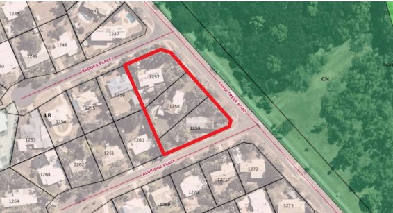
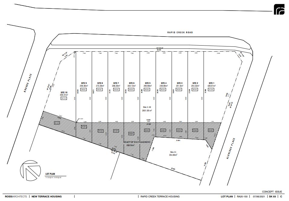
Closing 18th February 2022 - Public Meeting 5:30 Monday 14th February opposite 37 Rapid Creek Road
This is a very concerning application that will change the amenity of Rapid Creek Road and create an unacceptable precedent in the northern suburbs.
Tropics Consultancy Group has applied to the Minister for Infrastructure, Planning and Logistics for an Exceptional Development Permit (EDP) for the purpose of a subdivision and consolidation to create 11 lots (with 7 lots less than 300m2) and a building envelope plan on Lots 1257, 1258 and 1259 (1 Brooks Place, 37 Rapid Creek Road and 14 Aldridge Place, Milner) Town of Nightcliff.
Sue of Fannie Bay asks who made the decision to close the Parap Pool for maintenance in the middle of the school holidays and the hottest time of the year?
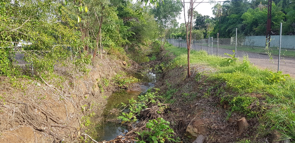
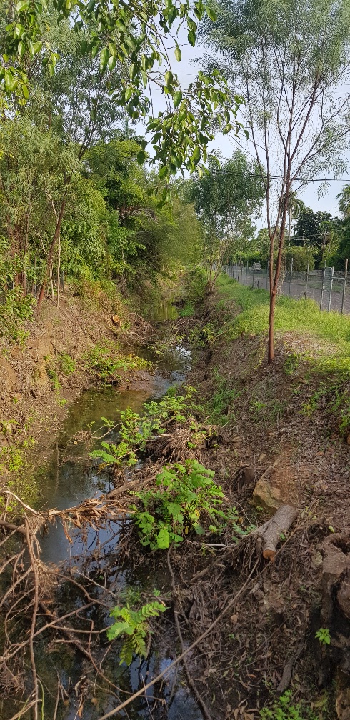
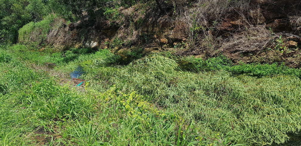
The answer is the City of Darwin (COD) and as a resident next to the Playford street Racecourse Creek / Drain I can report on my totally unsatisfactory recent experiences with the City of Darwin.
There is a perfectly functioning creek (now classified as a drain by the COD) that runs between Playford Street and the Darwin Turf Club. It provides a habitat for frogs, birds and wildlife. It has not been maintained by the COD for many years and during that time it has effectively managed stormwater dispersal, including during Cyclone Marcus.
In 2014 the former Lord Mayor and officials visited my home after some large trees were cut down by the COD under the excuse of “tree roots create mosquito breeding sites in the drain/creek”, so the trees have to go. The former Lord Mayor said future trees and native grass would be encouraged to grow in the area and trees won’t be felled again.
However, on 7 December 2021, COD contractors turn up and start chain-sawing down trees in thecreek/drain area and using a crane to lift them out. The COD advised this was to remove coffee bush – but no coffee bush was being cut – just trees, on the banks, floor and tops of the drain / creek.
So, undertakings given by the former Lord Mayor and staff to ratepayers are just ignored by the current Lord Mayor and staff - how unimpressive.
COD stopped work after my complaint and sent out a flyer on 14 th December to neighbours and residents briefly explaining the intended works are to enable the creek drain to perform at its design capacity and then recommenced tree cutting and chipping with assurances from the COD that trees on the top and sides of the bank will be left to minimize visual impacts and provide erosion control.
Then on 4th and 5th January, an unsupervised contractor walked up the creek/drain with a chainsaw and cut down many Acacia trees on the sides and top of the creek/drain. The COD response to this broken undertaking were to call these trees “weeds”. See pictures of felled trees.
And as a major stakeholder in the area and next to the Playford street drain/ creek, presumably the Darwin Turf Club were not consulted by COD prior to starting these tree felling works which has removed the treed buffer zone between the DTC facilities and the neighbours.
Then COD advised on 7th January, that once all the tree felling and clearing is complete, that the bottom of the creek/drain will be dredged. This fact was conveniently omitted from the COD notice to residents on 14 December 2021.
I wonder what the next instalment will be in this horror movie that shows the COD greening our city policy in action?
Meanwhile contractors are busy cutting trees, lifting them out with a crane and chipping them at a cost of $1000s per day. Yes, this is your rates at work. At the same time, COD has the tree seedling give aways and major landscaping programs to encourage a greener city and more flora and fauna – while at the same time destroying trees and habitat adjacent to Playford Street.
No COD Alderman, Lord Mayor or official has come to inspect these works and or discuss them with residents adjacent to these activities. The COD attempts to justify the works by saying they need to re-instate the creek/drain to its full capacity, presumably to protect houses from flood damage. But despite Cyclone Marcus and other big rain events, houses have not flooded. Sure, minor flooding of local roads can occur under huge rainfall events, but when the tide goes out, so does the flood water in the creek/ drain. It really is that simple.
COD are wasting ratepayers’ money on a make work project and removing habitat and also removing the visual screen between the neighbours and the Darwin Turf Club Grandstand, carpark and Stalls area. So much tree debris from one tree cutting exercise was left in the drain / creek that it recently washed down to Buntine Avenue, which is the entrance to the DTC from Dick Ward drive, and it acted as a beaver type dam, totally blocking the 2 large pipes there. This caused the road to flood and the water nearly went into Silks.
Hence claims by the COD re their expert technical monitoring and supervision of this project are just nonsense.
And where is the COD Erosion Control and Sediment Plan to prevent sediment moving off site and to prevent erosion on the banks now that the trees have gone? Where are the NT EPA in this matter, who approved these works, the COD itself it seems and why are these works not shown on the COD projects web site? Where are the hydrology studies used to justify these works and where was the public environmental approval process for these works? Or is the COD now above the law and it doesn’t care about sediment moving offsite, its greening policy and impact upon neighbours?
If the City of Darwin were sensible, they would stop wasting money, stop destroying habitat and the stability of the creek/ drain and work with the residents and the Darwin Turf Club to re-instate the trees and shrubs that have been unnecessarily removed. The residents are not against weed removal and tree removal in the base of the creek for stormwater flow.
But my guess is that the COD will keep doing what they are doing and wasting your rates as it appears to be someone’s pet project.
This work is NOT in the interests of ratepayers and should be stopped.
Here is an extract which appears to be concerning:
Establishing a Permitted Use Department of Infrastructure, Planning and Logistics Page 1 of 3
A permitted use under the NT Planning Scheme 2020 may not require a development permit.
However, if property is within a building control area, building certification may be required.
You don’t need a development permit for a permitted use if the development:
• meets all planning requirements, and
• does not require consent because of an overlay
Dear Stakeholder
We are excited to share with you that a planning scheme amendment for Planning Reform Phase 2 Stage 1 is now live and on public exhibition until midnight, Friday 4 March 2022.
The Minister for Infrastructure, Planning and Logistics has decided to consolidate 2 projects to form this amendment:
Economic Recovery Actions project – the NT Planning Scheme 2020’s response to the recommendations of the Territory Economic Reconstruction Commission; and
Designing Better project – the NT Planning Commission’s review of apartment and mixed use building design.
Both projects seek to improve processes and outcomes relating to the design of buildings and place.
We encourage you to read the Detailed Information Paper and associated documents, and make an appointment to speak with the Project Team about any clarifications, concerns or compliments. The Project Team will be exclusively available for booked appointments between Thursday 4 February and Friday 18 February 2022 across Darwin, Palmerston, Katherine and Alice Springs.
If you have any questions about the proposal in the meantime, please feel free to contact the Project Team on (08) 8999 8963 or viaThis email address is being protected from spambots. You need JavaScript enabled to view it..
Thank you for your ongoing interest in Planning Reform and/or Designing Better, and we hope to talk with you soon to receive your feedback.
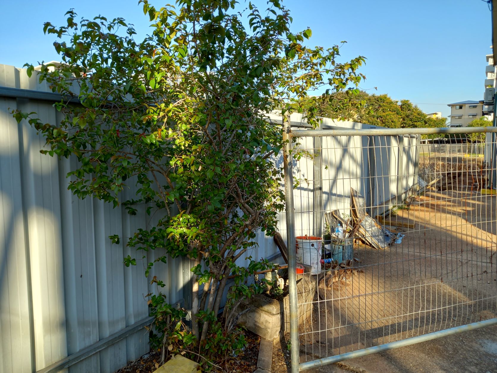
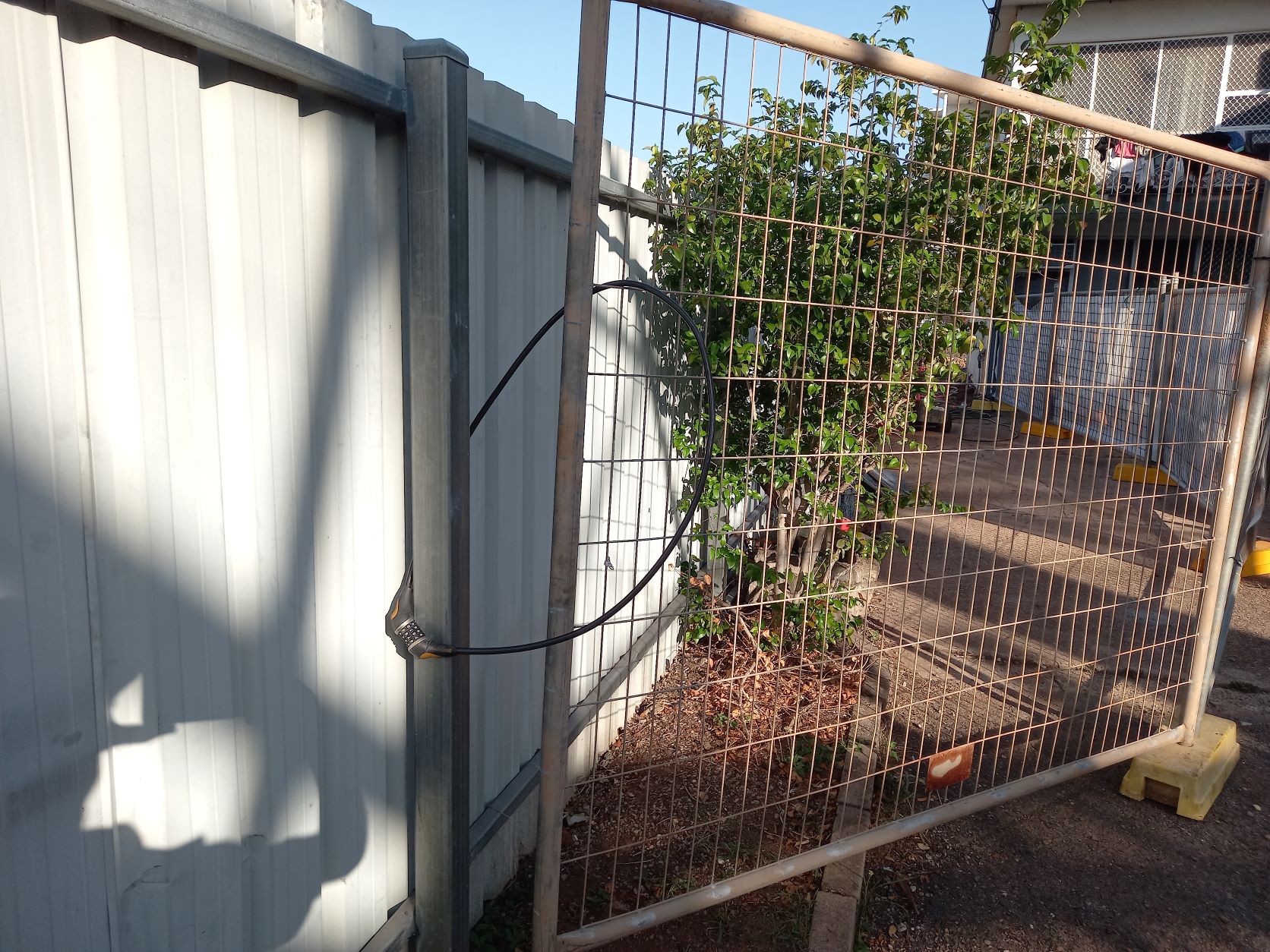
Some seven and a half years ago the site stalled, and Larrakeyah has been living with temporary fencing on three street fronts and a massive pit in the ground that holds water year-round.
In the latter years due to the building next door threatening to slide into the pit the owners have been backfilling the pit, we now have two deep pits with sheer walls that hold water year-round.
Late September 2021 builders turned up and began to excavate away the footings of the building that is falling into the pit.
No notice to nearby residents, no notification of who is doing the works and no secure gate.
All these pictures of gates are taken after 5pm when the site has been abandoned for the day.
This picture I took on the first night mid September. Rang NT Worksafe who I later learnt decided to take no action. The staff who work after 4:21pm do not have access to an email address photos can be sent to. The process is for the resident to send a sms to the NT Worksafe staff member’s personal phone. My SMS failed so no action.
After the weekend I contacted NT Worksafe again, and action occurred, signs went up identifying the builder and the gate was secured by some twist tie:
So again, I notified NT Worksafe advising that the twist tie will slip over the top of the gate. Next day a chain and padlock appear.
A week later the chain and padlock are replaced with a bicycle lock.
Slide the bike lock up the fence will come away from the post. I contacted NT Worksafe and the next day the bicycle lock was doubled over creating a tighter join.
This most recent photo is taken from inside the site at 5:20pm. Different gate, same effect, no one is watching these cowboy’s and our children are at risk.
Again I have rung NT Worksafe. So, four calls in two weeks, perhaps not good enough?
Urbanscope to the Development Consent Authority in September 2021
Below is the appplication that was submitted by Urbanscope to the Development Consent Authority in September 2021. Community submissions are closed except for those who arranged an extension.
Currently listed at the Development Consent Authority is:
Friday, 3 September 2021 – closes Midnight Monday, 4 October 2021
Address: Lot 07651 Town of Darwin 25 GILRUTH AVE THE GARDENS Current Zones: MZ (Multi Zone)
Proposed Development: Hotel/motel and serviced apartments with ancillary bar-public and market in 2 x 6 storey and 3 x 1 storey buildings with ground level and semi-basement car parking
Requested Variations:
Setbacks
Car Parking
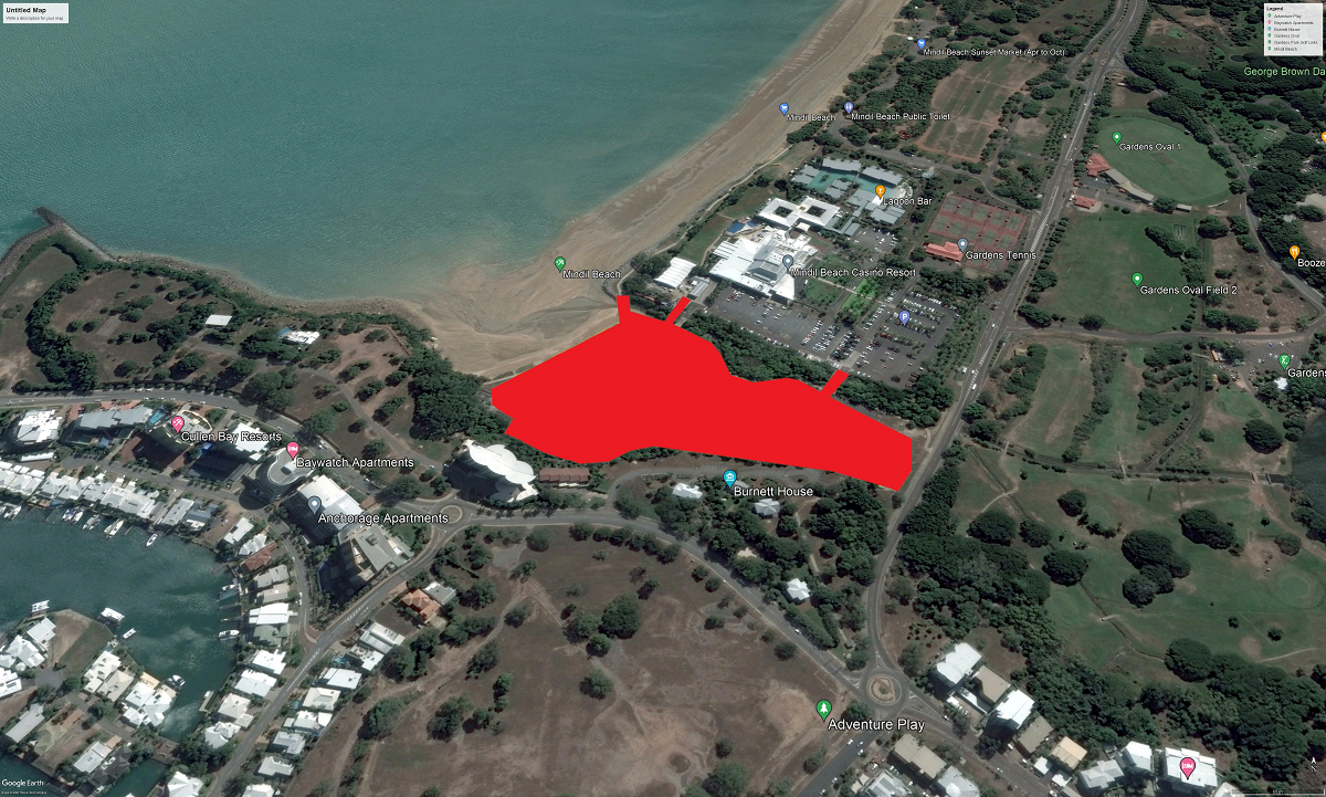
We know this site as Little Mindil, at the end of this article we have all the attachments to make it easier for the community to get access to this information. There was a long campaign to establish the public open space at Little Mindil. If you read the list of consultations that have been carried out we see that community have been omitted to date.
This is foreshore land and should always remain public open space.
This is an essential part of the total public recreational Mindil Beach Precinct, of which the Market site, the Golf Course, Waratah Oval, and the Botanic Gardens are also essential parts.
This whole area, next to the sea at Fannie Bay, is ringed by a high escarpment, which together forms a natural amphitheatre.
The NT Government made an agreement by which the large Little Mindil space was saved for the open relaxed recreational use of the people of Darwin. We need this open space area even more now, with a denser population in CBD.
Is the NT Government now going to change its mind, renege, and abandon the rights of the residents of Darwin at this point in time?
Friday, 28 May 2021 - Midnight Friday, 25 June 2021
Address:
Lot 07820 Town of Darwin
4 BLAKE ST
THE GARDENS
Current Zones:
SD46 (Specific Use)
Proposed Development:
67 x 2 and 34 x 3 bedroom dwellings-multiple and ground level commercial tenancies in a seven-storey building (comprising two towers) plus one level of basement car parking
Requested Variations:
No key variations identified. Read the application for full details.
The application is for consent to develop Lot 7820 for 101 dwellings-multiple and 250 m2 of ground floor retail and commercial floor space in a 7-storey building comprising two towers, set in landscaped surrounds, together with basement and undercroft parking.
The site is subject to the provisions of Zone SD46 in the NT Planning Scheme. An essential requirement of Zone SD46 is that the development is to contribute to improving the amenity of the Blake Street Precinct as an inner-city mixed use area by creating a landmark development through high architectural quality and distinctive streetscapes – see clause 3(a) of SD46. A proposal in 2018 was found by NT Civil and Administrative Tribunal (NTCAT) not to be a landmark development, and a Notice of Determination issued by DCA to consent to the application was revoked1 . There is no definition of “landmark” or “landmark development” in the Planning Act or Planning Scheme. In the course of its review of the 2018 proposal, NTCAT considered numerous definitions of these terms put forward by various experts. It settled on the definition of “landmark development” articulated by architect Ian Mitchell, then Principal of Conrad Gargett Architects.
The application is for permission to subdivide the land on Section 04106, at 1 Boulter Road, Berrimah into 36 lots for housing, with one park lot.
The site measures 7.44 hectares, and is at the corner of Amy Johnston Avenue and Boulter Road.
The land consists of three land use zones. These are Conservation (CN), Rural Residentia l(RR) and Low Density Residential (LR) each occupying about one third of the big lot.
You could access a full copy of the application by searching on Google using keywords ‘Developing applications online - Northern Territory’, then ‘Planning Notices’. You could instead use ‘www.ntlis.nt.gov.au//planning/ita/dar/list.
Next clicking the VIEW PROPOSAL button downloads all six sections of the application.
This may be more information than you want, as this application itself is very complex, and confusing.
If you wish, you may use the MAKE SUBMISSION button to make your submission online.
Also make yourself a copy of your submission before you send it off. (Ask for an acknowledgement).
Otherwise, you can use a PDF email, and send it to Development Assessment Services (DAS) at This email address is being protected from spambots. You need JavaScript enabled to view it..
Prepared submissions can also be hand delivered to:
First Floor Desk,
Energy House,
18-20 Cavenagh Street,
GPO Box 1680,
Darwin, NT 0801
NOTES FOR SUBMITTERS - SOME ISSUES
I hope this long list can help you make up a submission in time.
No response to the geographical situation of this land in a large catchment.
Poor physical layout of the proposed estate.
Focus is on over exploitation.
No empathy with the natural environment.
Lack of understanding of flood prone land inside and outside the Section.
Ignorance of the context of the Rapid Creek Catchment.
NTEPA should be involved in assessing the natural environment.
Conservation Zone should not be split between RR owners’ lots.
The layout of the RR and LR lots does not at all comply with the biting insects restriction.
Natural areas of the Conservation Zone cannot be reduced for any purpose.
Conservation zone, including should be excised to public ownership as the 'Marrara Wetland'.
Natural systems should be preserved.
No retention ponds to be built in the Conservation area.
No vegetation except weeds to be removed.
On Lot 04106 trees should be retained as much as possible.
NT Land Clearing Guidelines must be complied with.
Recommendations on land clearing too damaging because of mitigation ideas..
Concerns about water management on and off the site.
Remedying 0.15m 1% AEP Depth on 80% of Section 04106 surface, sounds very expensive.
Water run off down Rapid Creek must be clean.
Huge additional water runoff from 36 roofs, and new extra hardstand.
Flooding of Rapid Creek is already occurring at the Trower Road Bridge.
Clearing is continuing on International Airport land for commercial purposes.
Huge government moneys have been used on flood mitigation study for the catchment and houses in Rapid Creek Road.
Compliance is required with the Rapid Creek Management PLan.
The proposed roads are too narrow, and some other measurements may be questionable.
The Berrimah North Area Plan requires properly controlled run-off to avoid erosion and sediment.
An Erosion and Sediment Control Plan (ESCP) is required.
The Berrimah North Area PLan describes Boulter Road to be the FRONT STREET of a neighbourhood.
No Commercial neighbourhood yet exists, and there are not even any footpaths or bus stops in Boulter Road.
Neither is this present proposed layout conducive to creating an interactive neighbourhood with cosy shady places where families can gather, out of the sun. The present developments lack interest.
Nothing should occur until there is justice done by rehabilitating this land, No 1 Boulter Road after it was illegally cleared without NT Government penalty in 2014.
Please share with others if they are interested, but ask them to always send different submissions.
We would like to receive copies of some of your submissions.
Like a shell and pea switch game the practice of selling Community Purpose land to developers hides the obvious outcome.
Without confirming that the Community wants the asset to be relinquished government sells land like the top of the escarpment over the Botanical Gardens.
Then all the purchasing developer has to do is apply for a rezone and presto Community Asset is gone and inappropriate development is on the go.
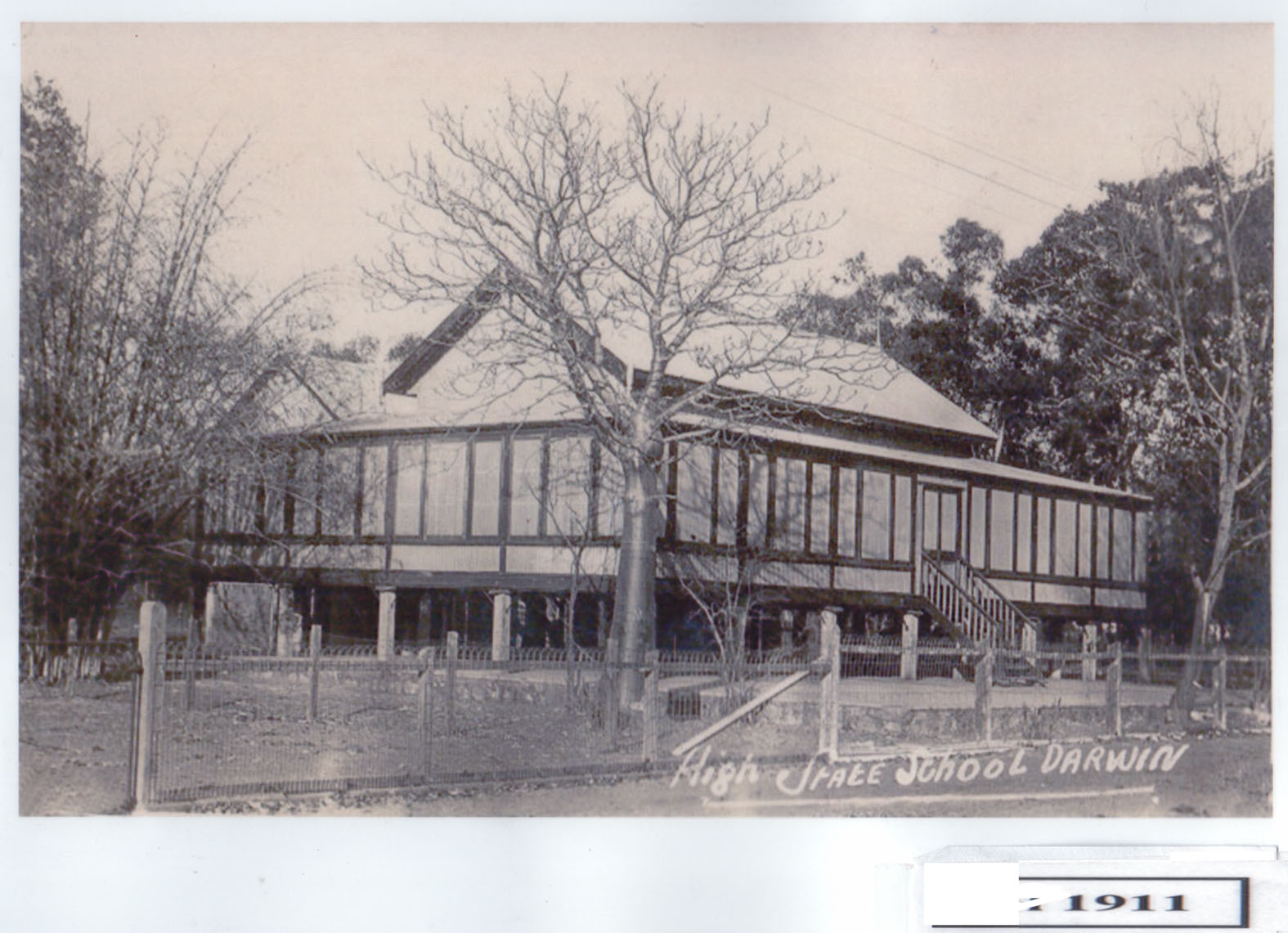
Here is the baby Boab tree dated 1911, and the other school building across Wood Street on the PO Carpark site. Supplied by Judy Boland. The trees near by may be Milkwoods.
Our valued volunteers man the office Thursday afternoon between 1pm and 5.30pm. We are located at 8/1 Buffalo Court, Darwin.
Contact
Post: GPO Box 2513, Darwin, NT, 0801
Phone: 08 8927 1999
Email: This email address is being protected from spambots. You need JavaScript enabled to view it.


 So, undertakings given by the former Lord Mayor and staff to ratepayers are just ignored by the current Lord Mayor and staff - how unimpressive.
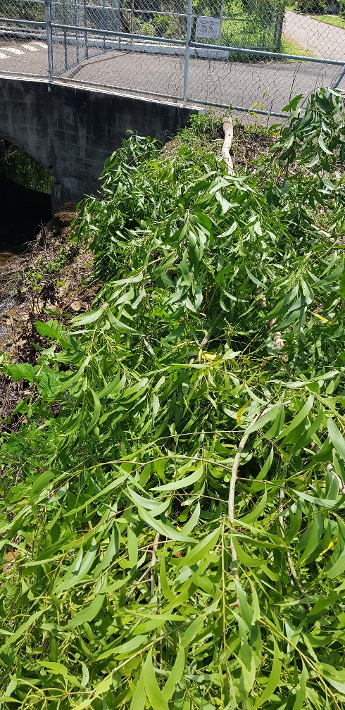 And as a major stakeholder in the area and next to the Playford street drain/ creek, presumably the Darwin Turf Club were not consulted by COD prior to starting these tree felling works which has removed the treed buffer zone between the DTC facilities and the neighbours.
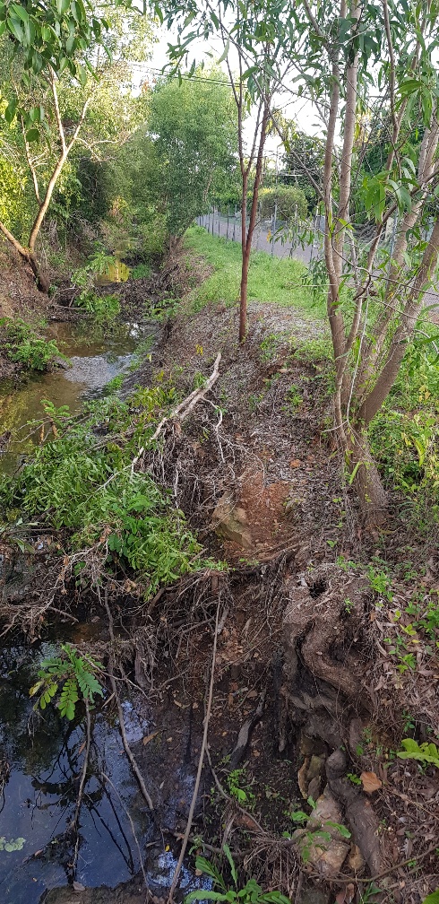 Meanwhile contractors are busy cutting trees, lifting them out with a crane and chipping them at a cost of $1000s per day. Yes, this is your rates at work. At the same time, COD has the tree seedling give aways and major landscaping programs to encourage a greener city and more flora and fauna – while at the same time destroying trees and habitat adjacent to Playford Street.
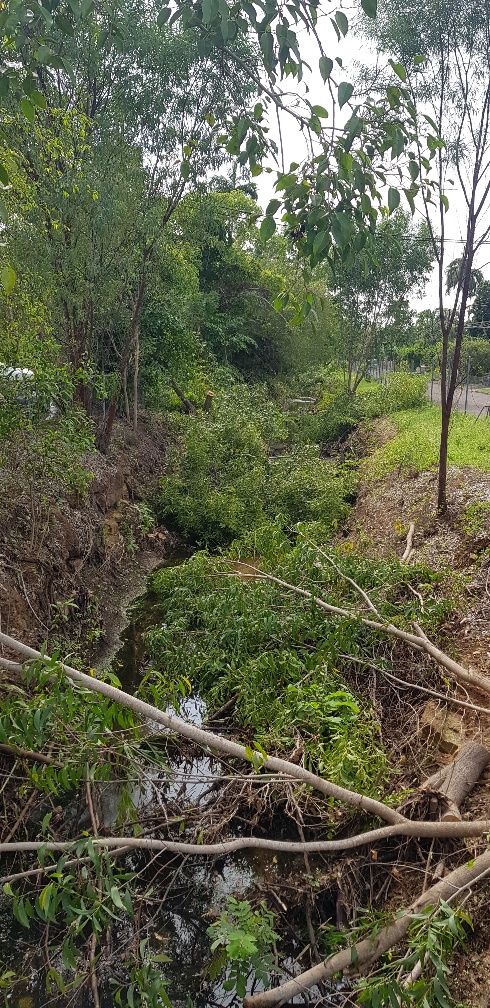 COD are wasting ratepayers’ money on a make work project and removing habitat and also removing the visual screen between the neighbours and the Darwin Turf Club Grandstand, carpark and Stalls area. So much tree debris from one tree cutting exercise was left in the drain / creek that it recently washed down to Buntine Avenue, which is the entrance to the DTC from Dick Ward drive, and it acted as a beaver type dam, totally blocking the 2 large pipes there. This caused the road to flood and the water nearly went into Silks.
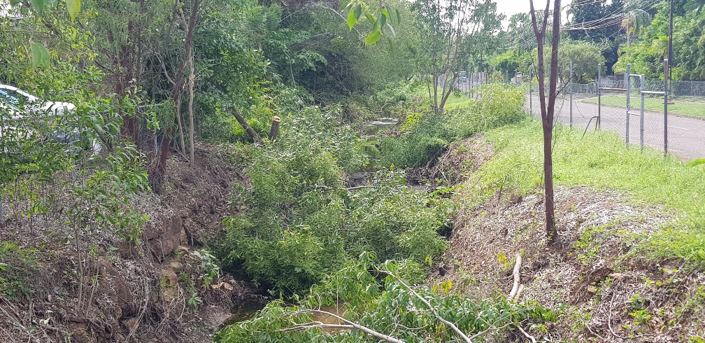 If the City of Darwin were sensible, they would stop wasting money, stop destroying habitat and the stability of the creek/ drain and work with the residents and the Darwin Turf Club to re-instate the trees and shrubs that have been unnecessarily removed. The residents are not against weed removal and tree removal in the base of the creek for stormwater flow.