Contents
Here is the link to the petition: https://actionnetwork.org/petitions/friends-of-farrar/
On this page you can find links to the previous events
Next comes the application documents
After that we have published an Overview & Site Parameters
Here is the Submission Guide
And a Long Submission Guide
Petition and Previous Events
See here for previous events:
https://planinc.org.au/friends-of-farrar/
This is the petition for the Chief Minister:
https://actionnetwork.org/petitions/friends-of-farrar/
Application Documents
Note the are two versions of this first document:
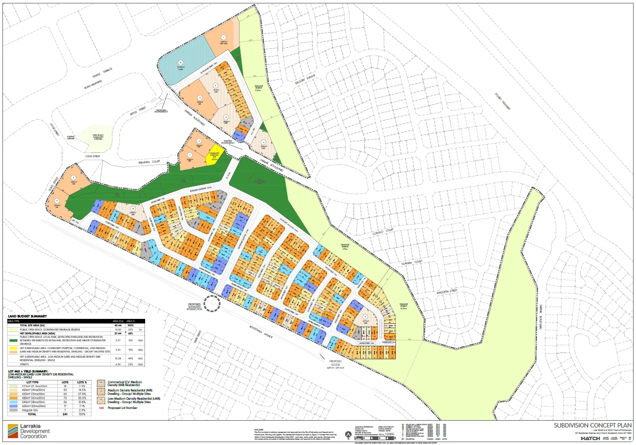
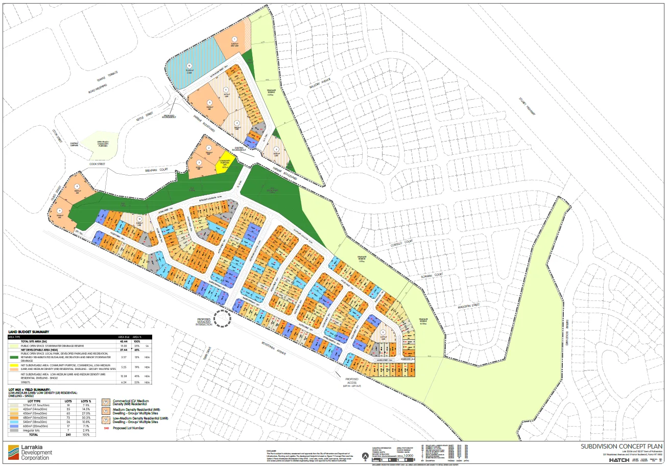
Overview & Site Parameters
- Site Location: Lots 13256, 13257, and 13260 Town of Palmerston (231 Roystonea Avenue, 5 Farrar Boulevard, and 6 Gurd Street, Farrar, NT).
- Site Dimensions: Total site area of 42.42 ha, comprising a 27.44 ha Net Developable Area and 15.06 ha in dedicated drainage reserves.
- Proponent: Larrakia Development Corporation (LDC) / Cuttone Property Group under a Project Development Agreement with the Northern Territory Government.
- Current & Intended Zoning: The land is currently zoned FD (Future Development). Stage-by-stage normalisation rezonings will establish Zone LR (Low Density Residential), Zone LMR (Low-Medium Density Residential), Zone MR (Medium Density Residential), Zone CP (Community Purpose), and Zone PS (Public Open Space). The commercial parcel will retain Zone FD to ensure future development is evaluated under the Palmerston Eastern Suburbs Area Plan (PESAP).
Subdivision Yield & Lot Composition
The proposal outlines 263 total allotments delivered across seven primary stages:
- 241 Single-Dwelling Lots: Ranging from 363 m2 to 1,027 m2 (average area 497 m2).
- 39 lots are ≥600 m2 (intended Zone LR). PDF+ 1
- 202 lots are 363 m2 to 599 m2 (intended Zone LMR).
- 5 Low-Medium Density (LMR) Lots: Totaling 1.58 ha, designated for 2-storey grouped or multiple dwellings (~43 to 84 total dwellings).
- 6 Medium Density (MR) Lots: Totaling 2.16 ha, located primarily near the Temple Terrace activity corridor for up to 4-storey development (~139 to 191 total dwellings).
- 1 Commercial / Mixed-Use Lot: 1.0 ha allotment fronting Temple Terrace, intended for convenience retail, local services, food/beverage, and commercial space.
- 1 Community Purpose Lot: 1,577 m2 site fronting Farrar Boulevard.
- 6 Public Open Space Lots: Totaling 3.57 ha (13% of the net developable area, exceeding the 10% statutory requirement). Comprises a 1.39 ha active local park, 3 pocket parks, and a 2.03 ha linkage corridor.
- 3 Drainage Reserves: Totaling 15.06 ha to accommodate realigned drainage channels and a regional flood detention basin.
Environmental & Species Assessment
- NT EP Act Screening: EcOz Environmental Consultants’ pre-referral screening concluded that the project is unlikely to have a significant environmental impact under the Environment Protection Act 2019 and does not require formal referral to the NT EPA.
- EPBC Act Listed Threatened Species:
- Typhonium praetermissum (Endangered): 222 plants were recorded on site. The layout retains ~48 plants (22%) in situ within the upper drainage reserve. The removal of 174 plants represents ~4.7% of the Holtze-Palmerston sub-population (and 1.4% of the total estimated species population), which was assessed as not compromising the long-term viability of the regional population.
- Typhonium johnsonianum (Data Deficient): 2 occurrences recorded on site (1.4% of total NT Atlas records), assessed as low impact due to wide regional availability of suitable unmapped habitat.
- Mertens’ & Mitchell’s Water Monitors: The local drainage channel offers marginal, degraded habitat; potential impact was assessed as low.
- Northern Brushtail Possum & Darwin Cycad: Present on site; significant impact likelihood was assessed as low.
Stormwater & Flood Management Strategy
- Catchment Hydrology: The site sits in the upper catchment of Mitchell Creek.
- Channel & Infrastructure Works: Realigns existing pipe network outlets near the Farrar Boulevard roundabout into a new 20 m base-width grassed channel and installs a 7×1200×600 mm RCBC crossing under Farrar Boulevard.
- Dry Detention Basin: Features a 24,500 m3 capacity dry basin (expanding to 54,500 m3 storage at 1% AEP peak water level RL 19.8 m) that merges the eastern and western flow paths.
- Flood Impact Mitigation: WRM hydrologic/TUFLOW modelling confirms that the basin reduces peak 1% AEP off-site discharges by 13% overall compared to pre-development conditions (Roystonea Ave outfall reduced by 6%, Inverway Cct outfall reduced by 16%), eliminating off-site flood impacts on neighbouring properties.
Traffic, Access & Servicing
- Traffic Generation: The development is projected to generate 4,833 daily vehicle trips and 469 peak-hour trips at full completion.
- Intersection Modeling: SIDRA intersection analysis indicates that key external intersections (Roystonea Ave / Terry Dr and Farrar Blvd / Kettle St) will continue operating well within capacity 10 years post-development (Degree of Saturation max 0.83 and 0.19 respectively).
- Road Hierarchy: Internal network incorporates Secondary Collector roads (21.6 m reserve), Access Streets (16 m reserve), and Minor Streets / Culs-de-sac (15 m reserve).
- Reticulated Utilities: All allotments will connect to reticulated power, water, sewerage, telecommunications, and underground stormwater systems. Earthworks are structured across 3 bulk stages designed to achieve a balanced cut/fill on site without importing fill material.
Submission Guide
FARRAR WEST DEVELOPMENT — SUBMISSION GUIDE
Help Protect Farrar Bushland & Mitchell Creek in 5 Minutes
Closes: Midnight Friday, 6 November 2026
Refer to this guide to write and lodge your official objection to the Development Consent Authority (DCA) before the statutory deadline.
Essential Submission Details
- Target Authority: Development Consent Authority (DCA)
- Application: Concurrent Planning Scheme Amendment & Subdivision Application — Lots 13256, 13257 & 13260 Town of Palmerston (Farrar West)
- Email Submission To: das.ntg@nt.gov.au
- Subject Line: OBJECTION — Farrar West Development Application (Lots 13256, 13257 & 13260)
Step-by-Step Writing Guide
Step 1: Provide Your Details (Top of Email)
Include your Full Name, Residential Address, Email, and Phone Number. Submissions without contact details may not be formally logged by DAS.
Step 2: State Your Decision Request
Start clearly:
“I am writing to lodge my formal OBJECTION to the Farrar West concurrent development application. I urge the DCA to REFUSE this application or DEFER a decision until a formal Environmental Impact Statement (EIS) is conducted by the NT EPA.”
Step 3: Choose 1 to 3 Key Objection Grounds (See suggestions below)
Select the points that matter most to you and rephrase them in your own words.
Step 4: Add Your Personal Impact Statement (1–2 Sentences)
Explain how this directly affects you (e.g., traffic on Farrar Boulevard, storm runoff near your fence, loss of neighbourhood walking trails, or heat/density concerns).
The 3 Core Objection Grounds
Ground 1: Bypassed Environmental Assessment & Endangered Species Loss
- The Issue: The project clears 42.42 hectares of intact Top End savanna and destroys 174 endangered Typhonium praetermissum plants (~80% of the site population).
- Key Point: The developer used a private consultant screening (EcOz) to bypass a formal referral to the NT EPA. Destruction of endangered species and major savanna clearing must undergo an independent statutory assessment under Section 48 of the Environment Protection Act 2019 before any planning permit is considered.
Ground 2: Mitchell Creek Realignment, Downstream Flood Risk & Council Costs
- The Issue: The natural upper headwaters of Mitchell Creek will be cleared and realigned into an artificial 20-metre grassed channel and a 24,500 m³ dry detention basin.
- Key Point: Replacing natural land sponges with hardstand pavement increases overland flood risks for existing homes along Farrar Boulevard and Gurd Street during peak 1% AEP monsoonal storms. Furthermore, handed-over detention basins create permanent siltation, weed control, and maintenance liabilities for City of Palmerston ratepayers.
Ground 3: Inappropriate Density, Procedural Bundling & Urban Heat
- The Issue: The application bundles broad “Future Development” (FD) rezoning together with a detailed 263-lot civil layout in a single concurrent step.
- Key Point: Introducing lot sizes down to 363 m² and medium-density unit blocks up to 4 storeys strains local roads, increases traffic congestion, overfills local schools, and strips mature tree canopy—intensifying urban heat in Farrar.
Top Tips for Maximum Impact
- Keep it Respectful & Evidence-Based: Focus on land suitability, traffic safety, environmental risk, and neighbourhood amenity (Section 51 of the Planning Act 1999).
- Individual Emails Matter: Encouraging separate members of your household to send their own personalized email creates a higher total submission tally.
- Share the Link: Forward [https://planinc.org.au/farrar-west-development/](https://planinc.org.au/farrar-west-development/) to your street group or Facebook friends.
Long Submission Guide
Farrar West Proposal Submission
Executive Summary: The Farrar West Proposal and Community Accountability
The Farrar West proposal is uniquely positioned as a beneficiary of approximately $11 million in public federal infrastructure funding under the Housing Support Program, designed to unlock housing supply. However, public investment must demand public accountability. The proponents cannot rely on taxpayer-funded headworks subsidies while simultaneously shielding themselves behind ‘market demand’ clauses that allow for protracted staging, deferred open spaces, and uncertain project timelines. The DCA must condition any development permit to ensure that public funding translates into guaranteed, front-loaded community and environmental infrastructure rather than speculative land release.
The application attempts to have it both ways: it relies on high-level strategic buzzwords like ‘compact urban growth’ and ‘environmental integration’ to justify rezoning Zone FD land, but downplays environmental values, bypasses mandatory planning restrictions (like medium-density cul-de-sac bans), and pushes engineering quick-fixes onto public infrastructure. When viewed as a whole, the proposal represents over-intensified suburban sprawl that sacrifices environmental integrity for yield.
When you read the Statement of Effect and its technical attachments as a whole, a series of glaring contradictions emerges between what the applicant claims on paper and what the actual on-the-ground reality will be.
Here are sample contradictions that make little sense when analysing the application as a unified whole:
1. The “High-Density on a Dead-End” Contradiction
- What the Application Claims: The Statement of Effect and planning reports emphasize that medium-density and multi-dwelling sites are strategically placed near the Temple Terrace corridor and major access points to encourage walkability, transit use, and efficient traffic flow.
- Why It Makes No Sense: Despite this policy, the applicant placed Medium-Density Lot 7 directly at the absolute end of Brennan Court—a cul-de-sac. Clause 6.2.1(12)(c) of the NT Planning Scheme explicitly states that medium/higher-density residential lots must not be located in a cul-de-sac because multi-unit traffic, visitor parking, and service vehicles (like garbage trucks) overload dead-end streets. The proponent tries to wave this away by arguing Brennan Court’s road reserve is slightly wider, completely ignoring the fundamental traffic and safety purpose of the Planning Scheme rule.
2. The “Degraded Habitat” vs. “Valuable Green Corridor” Contradiction
- What the Application Claims: In the environmental pre-referral screening (Attachment G), the consultants dismiss local biodiversity, arguing that the site’s native vegetation and habitat for threatened species (Typhonium praetermissum and local fauna) are already heavily “degraded” by urban edges, weeds, and past disturbance.
- Why It Makes No Sense: Yet, in the Public Open Space Landscape Masterplan (Attachment C) and the Statement of Effect, the applicant turns around and brands those exact same drainage corridors and bushland patches as a glowing environmental asset—a “2.03ha linkage park allowing people to immerse in nature”. You cannot write off native vegetation as disposable “degraded weeds” to dodge an NT EPA environmental impact assessment, and then market those exact same compromised strips as premium ecological open space to sell housing lots.
3. The “Improved Drainage” vs. “Massive Concrete / Dry Basin” Contradiction
- What the Application Claims: The Stormwater Management Plan (Attachment E) claims that replacing natural upper headwaters with an engineered 20-metre-wide trapezoidal open channel, concrete low-flow inverts, and a massive dry detention basin will improve downstream flooding and mitigate historical runoff issues toward Inverway Circuit.
- Why It Makes No Sense: Channelising a natural headwater into a sterile, engineered conveyance system alters flow velocities and concentrates peak monsoonal runoff. Relying on dry basins and 4-metre-wide council fire/maintenance strips shifts the burden of weed management, bank erosion, and mosquito control onto local ratepayers, all while destroying the natural hydrological sponge that previously absorbed rainfall on-site.
4. The “Compact Growth” vs. “Suburban Sprawl” Contradiction
- What the Application Claims: The planning reports cite the Darwin Regional Land Use Plan and the Palmerston Eastern Suburbs Area Plan (PESAP), boasting that Farrar West delivers “compact, accessible, and walkable greenfield growth”.
- Why It Makes No Sense: When you examine the lot mix, 84% of the single-dwelling lots (202 out of 241) are standard sub-600 m2 suburban blocks relying on zero-lot-line (300 mm) side boundary setbacks. This isn’t innovative “missing middle” urbanism; it is traditional low-density suburban sprawl crammed onto tighter parcels, which maximizes developer yield while stripping away private yard space and mature tree-canopy zones.
SECTION 1: LEGAL REQUIREMENTS & STATUTORY OBLIGATIONS
The Farrar West development proposal triggers a complex suite of statutory mechanisms under the Planning Act 1999 and the Northern Territory Planning Scheme. When evaluated against the statutory framework, the application reveals significant vulnerabilities and gaps across four core legal pillars:
1. Assessment Track & Master Plan Normalisation
- Impact-Assessable Pathway: Because the site is currently zoned FD (Future Development), the proposal is legally classified as Impact-Assessable, requiring rigorous public scrutiny against the Strategic Framework.
- The “Normalisation” Ambiguity: Rather than an upfront statutory rezoning, the application splits the process: it seeks an immediate Development Permit for a 263-lot subdivision while deferring the operational zoning conversions (to Zones LR, LMR, MR, CP, and PS) to subsequent, fragmented Planning Scheme Amendments. This piecemeal approach creates regulatory ambiguity and risks disconnecting long-term land use outcomes from immediate civil works.
- Myopic Master-Planning: The master plan fails to account for regional integration. By treating the 42.42-hectare cadastral boundary as an isolated island, it ignores the broader cumulative impacts on regional stormwater catchments (Mitchell Creek), sub-arterial traffic flows, and ecological wildlife corridors.
2. Strategic Alignment under the Palmerston Eastern Suburbs Area Plan (PESAP)
- Policy vs. Reality: Under the NT Planning Scheme, the proposal must demonstrate tight integration with regional land release policies and sequenced infrastructure delivery. However, the reliance on stage-by-stage normalisation rezonings threatens holistic oversight.
- Commercial Safeguards vs. Staging Delays: While the application deliberately retains Zone FD provisions on the commercial/mixed-use pad fronting Temple Terrace to ensure future built-form oversight, this regulatory mechanism risks letting commercial and community infrastructure lag indefinitely behind surging residential populations as is seen in other such developments.
3. Environmental Legislation & The Burden of Proof (Environment Protection Act 2019)
- Bypassing Independent EPA Scrutiny: Rather than triggering a transparent, independent Environmental Impact Statement (EIS) overseen by the NT EPA, the proponents relied on a pre-referral screening report by private consultants (EcOz).
- Unacceptable Environmental Offsets: The screening report dismisses the clearing of 42.42 hectares of native savanna and the destruction of 174 individual plants of the EPBC-listed Endangered Typhonium praetermissum (roughly 80% of the site’s population) as manageable via off-site regional offsets. Relying on broad regional offsets while confining local conservation to narrow, degraded drainage corridors sets a poor precedent for biodiversity protection.
4. Technical and Engineering Compliance Gaps
- Stormwater & Flood Shifting: While claiming post-development peak flows will not exceed pre-development baselines, the engineering relies on capacity-constrained Roystonea Avenue culverts that force 1% AEP monsoonal storm flows to overtop crests and surcharge toward Inverway Circuit. Furthermore, relying on massive dry detention basins dumps long-term maintenance and weed liabilities onto City of Palmerston ratepayers.
- Traffic Pressures: The development will inject approximately 4,833 vehicle trips per day into the local network. Approvals must legally mandate that intersection upgrades and headworks are fully front-loaded prior to the occupancy of early residential stages.
- Compromised Open Space: While the 3.57 hectares of Public Open Space (13% of the Net Developable Area) technically clears the mathematical 10% threshold, a significant portion is intertwined with stormwater drainage reserves—effectively double-counting active inundation zones as community recreation space.
SECTION 2: COMMUNICATIONS, CONSULTATION & PUBLIC ENGAGEMENT DEFICITS
While the Farrar West proponents and administering authorities technically satisfied statutory notification minimums—such as publishing documents on the NT Government’s Development Applications Online (DAO) portal, erecting physical “pink signs” on Roystonea Avenue and Farrar Boulevard, and establishing a project website—the practical reality of public engagement for this major impact-assessable development is deeply flawed.
This submission can highlight three major communication and procedural deficits:
1. Public Relations Spin vs. Technical Transparency
- Omission of Critical Risks: The proponent-led communication materials (such as glossy FAQs and community update sheets) function primarily as public relations brochures. They prominently market headline benefits—like housing lot numbers and open space percentages—while completely omitting or glossing over major environmental and engineering constraints.
- Buried Complexities: Critical risks, such as the destruction of local Typhonium praetermissum populations or capacity-constrained regional culverts forcing monsoonal stormwater toward Inverway Circuit, are buried deep within dense technical appendices rather than being disclosed in plain English for affected residents.
2. The Asymmetry of Information and Resources
- An Unequal Playing Field: The project represents years of work by paid consultants and corporate entities designed to tick statutory boxes. In stark contrast, volunteer-driven community networks and everyday citizens are expected to decode complex hydrological modelling, SIDRA traffic matrices, and EPBC pre-referral screenings within a rigid, inflexible 28-day public exhibition window.
- Procedural Inequity: For major greenfield master plans with permanent regional impacts, standard consultation windows fail to provide genuine, accessible channels for community comprehension, creating an inherent barrier to natural justice and public participation.
3. Strategic Recommendations for the Development Consent Authority (DCA)
To address these systemic communication barriers, this submission recommends that:
- Mandatory Plain-Language Summaries: The Department mandate plain-language executive summaries for all major impact-assessable development applications so that the community can readily understand the true trade-offs of proposed master plans.
- Genuine Engagement Frameworks: Community consultation processes must prioritise transparent, accessible disclosures over developer-led marketing spin.
SECTION 3: TRAFFIC IMPACT ASSESSMENT & TRANSPORT NETWORK DEFICITS
The Traffic Impact Assessment (TIA) submitted in support of the Farrar West development relies heavily on standard, car-centric computer modelling that fails to measure up against contemporary Australian best practice (such as the Austroads Guide to Traffic Management and “Movement and Place” frameworks).
This submission can highlight four major traffic and transport deficits:
1. Massive Traffic Surge vs. Isolated Intersection Modeling
- The Scale of Impact: At full build-out across the ~263 residential lots, medium-density sites, and commercial footprints, the development is projected to generate approximately 4,833 vehicle trips per day (with around 469 movements during the peak hour).
- The Analytical Flaw: The TIA relies narrowly on isolated SIDRA software modeling for specific intersections (such as Roystonea Avenue / Terry Drive and Farrar Boulevard / Kettle Street). It treats these nodes as self-contained units rather than modeling the compounding ripple effects of funneling nearly 5,000 daily trips through surrounding collector networks and existing suburban streets.
2. Car-Centric Focus Ignored Multi-Modal Realities
- Lack of Active Transport Scrutiny: True best-practice transport planning evaluates safety and accessibility equally across all modes, including public transport, cycling, and walking.
- The Shortfall: The Farrar West TIA functions essentially as a vehicle-capacity check. It provides little meaningful assessment of pedestrian permeability or cyclist safety—particularly for school children and residents crossing high-volume collector paths or interfacing with the new signalised entry on Roystonea Avenue.
3. Omission of Construction Traffic and Amenity Impacts
- Deferred Accountability: Major construction impacts—such as heavy vehicle haulage routes, civil earthmoving frequencies, noise, and vibration footprints across the multi-year rollout—are largely omitted from active scrutiny.
- Impact on Existing Residents: Deferring these details to post-approval management plans leaves existing residents on streets like Farrar Boulevard completely in the dark regarding how heavy transport fleets will disrupt their daily amenity.
4. Lagging Infrastructure and Staging Risks
- The Sequencing Danger: While a new signalised intersection at Roystonea Avenue / Terry Drive is proposed to absorb traffic, the development’s multi-stage rollout spans several years. There is a serious risk that early-stage residential traffic generation will outpace physical road upgrades if headworks are permitted to lag behind lot sales.
Strategic Recommendation for the Development Consent Authority (DCA):
The submission calls out that the consent authority mandate strict, front-loaded transport conditions—ensuring all major intersection upgrades (including the Roystonea Avenue signalised connection) are fully constructed and operational prior to the physical occupation of Stage 1 residential lots, rather than allowing traffic mitigation to trail behind developer staging.
SECTION 4: STORMWATER, DRAINAGE & DARWIN WET SEASON RISKS
The Stormwater Management Plan (Attachment E) relies heavily on computer-modeled peak flow reductions (claiming a 13% overall reduction across discharge points). However, when tested against the physical realities of a Top End tropical wet season, the engineering strategy presents significant operational, environmental, and maintenance risks:
1. High-Volume Monsoonal Inflows vs. “Dry” Detention Capacity
- The Wet Season Reality: Darwin experiences intense, sustained downpours—particularly in January and February—where consecutive days of heavy rain drop massive volumes of water.
- The Engineering Flaw: The plan relies on a 24,500 m³ dry detention basin (scaling up to 68,000 m³ at maximum capacity) designed to drain completely within 72 hours. In continuous wet-season weather, soils remain saturated, and basins will fill rapidly and repeatedly, severely testing the structural integrity of earth bunds and spillways between storm events.
2. Loss of Natural Sponges and Increased Hydraulic Pressure
- Hardstand Acceleration: Replacing 42 hectares of natural bushland “sponges” with roofs, roads, and concrete hardstands dramatically accelerates runoff velocity.
- Downstream Surcharge Risks: While computer models show lower peak discharge at select points, funneling extreme monsoonal volumes through engineered pipe networks and concrete low-flow channels increases local hydraulic pressure, exacerbating historical capacity constraints on downstream infrastructure (such as Roystonea Avenue culverts and Inverway Circuit).
3. Wet Season Earthworks and Erosion Hazards
- Exposed Topography: Scheduling earthworks or staging near the onset of the wet season exposes raw tropical soils to heavy downpours, creating major risks for severe soil erosion, sediment washaways, and turbid runoff entering Mitchell Creek.
- Mitigation Failures: Maintaining vegetation stabilisation and temporary silt traps during relentless monsoonal rain is exceptionally difficult, often leading to environmental compliance breaches.
4. Maintenance Liabilities & Vector Breeding
- Ratepayer Burden: Engineered drainage assets, massive dry basins, and 4-metre-wide council fire/maintenance strips create permanent weed-control and siltation liabilities that will ultimately be dumped onto City of Palmerston ratepayers.
- Mosquito Hazards: If maintenance intervals slip or sediment builds up in low-flow pipe connections during the wet season, stagnant pooling creates ideal breeding grounds for mosquitoes and midges, threatening local health and amenity.
SECTION 5: ECONOMIC ASSESSMENT, MARKET DRIVERS & CAR-CENTRIC SPRAWL
The Economic Assessment (Attachment H, prepared by Hatch) relies heavily on demographic assumptions of “high car ownership and strong commuter flows” to justify a traditional, vehicle-reliant commercial and residential layout. When evaluated against contemporary best-practice urban economics and progressive design principles (such as those outlined by Infrastructure Australia and the Planning Institute of Australia), the economic strategy exhibits several major shortcomings:
1. The Car-Centric Trap vs. 15-Minute Neighborhoods
- The Economic Driver: Hatch’s assessment explicitly targets convenience-based, car-oriented commercial uses—such as service stations, fuel stops, and passing-trade footprints—designed to capture motorists flying off Roystonea Avenue and Farrar Boulevard.
- The Planning Deficit: This approach locks in permanent car dependency. In contrast to modern “15-minute neighborhood” models that prioritise active transport, the development’s internal design and commercial layout funnel nearly 5,000 daily vehicle trips onto the surrounding road network without providing a true, connected active transport spine.
2. The Ratepayer Burden and Whole-of-Life Infrastructure Costs
- Public Subsidisation: The project is heavily supported by approximately $11 million in federal funding under the Housing Support Program to remove upfront utility bottlenecks.
- Long-Term Liabilities: While public funds de-risk the initial land release, local City of Palmerston ratepayers are left holding the long-term financial and operational burden of maintaining massive civil assets—including the 24,500 m³ dry detention basin, 4-metre-wide firebreaks, and sprawling drainage reserves—with recurring maintenance costs poorly balanced against long-term municipal revenue.
3. Housing Diversity vs. Cookie-Cutter Suburban Sprawl
- Yield Skew: Despite claims of compact greenfield growth, over 90% of the housing yield remains traditional low-to-medium density single-dwelling lots (241 out of 263 total allotments).
- Missed Opportunity: The economic and master-planning framework misses the chance to pioneer true “missing middle” density (such as evenly distributed townhouses, courtyard homes, and flexible live-work spaces) that supports multi-generational living and aging in place, defaulting instead to a 20th-century suburban subdivision model.
4. Microclimate and Urban Heat Deficits
- Landscape Stripping: The focus on engineering convenience and car-oriented commercial footprints leads to the clearing of 42 hectares of native savanna and the creation of hardstand parking zones. This exacerbates the severe urban heat island effect native to Palmerston’s tropical climate, failing to integrate living stormwater networks or shade-engineered public realms as foundational economic and design assets.
Strategic Recommendation for the Development Consent Authority (DCA):
This submission urges the DCA to condition any development approval to ensure that publicly subsidised land release translates into genuine, climate-resilient community benefits—requiring higher architectural and landscaping standards, robust active transport linkages, and enforceable protections against long-term municipal maintenance burdens.
SECTION 6: INFRASTRUCTURE SERVICES, GEOTECHNICAL REALITIES & ENGINEERING LIABILITIES
The engineering, geotechnical (CMW Geosciences), and material testing (Construction Sciences CBR) reports uncover the physical realities behind the Farrar West civil design. While the developer presents a polished engineering strategy, a rigorous review of the infrastructure documentation reveals significant risks for public safety and local assets:
1. Geotechnical Mass-Shaping and Topography Risks
- Site Classification and Excavation: The geotechnical reports classify the 42.42-hectare site as a reactive Class S environment, noting shallow underlying bedrock (Laterised Siltstone and Porcellanite) in western elevations and deeper clay soils in eastern zones.
- The Civil Impact: Executing a balanced cut-and-fill strategy across 10 construction steps requires heavy machinery (such as rippers and rock breakers). Stripping and mass-shaping this terrain right across the upper headwaters of Mitchell Creek risks destabilizing natural topography and triggering severe erosion if not tightly managed.
2. Downstream Flooding and Culvert Capacity Constraints
- The Infrastructure Bottleneck: The civil plans confirm that existing regional culverts on Roystonea Avenue are strictly capacity-constrained. To manage the 42 hectares of new hardstand runoff, the plan relies on a massive 24,500 m³ dry detention basin.
- The Public Risk: Because downstream outlets cannot be safely enlarged without worsening flooding elsewhere, extreme monsoonal storm events risk overtopping local crests and surcharging toward adjacent residential catchments like Inverway Circuit and Gurd Street.
3. Dumping Maintenance Liabilities onto Ratepayers
- Transfer of Burden: The civil infrastructure documents outline extensive open drainage channels, gross pollutant traps, and dry detention basins that will ultimately be handed over to the public sector.
- The Ratepayer Cost: Local City of Palmerston ratepayers will inherit permanent, recurring financial and operational liabilities for ongoing weed management (such as controlling Gamba grass in buffer zones), silt removal, and structural basin maintenance.
4. Staging and Construction Runoff Hazards
- Wet Season Vulnerability: Civil construction spans multi-year staging phases. If earthworks overlap with the Top End wet season, exposed soils and uncompacted fill pads face severe washaway risks, threatening to choke local waterways with turbid silt.
Strategic Recommendations for the Development Consent Authority (DCA):
The submission calls for the consent authority to impose strict, enforceable conditions on any development permit:
- Zero Flood Surcharge Guarantee: Mandate that post-development peak flows prove absolute zero flood risk or surcharge toward Inverway Circuit under all simulated climate and monsoonal scenarios.
- Infrastructure Front-Loading: Require all stormwater basins, drainage channels, and intersection headworks to be fully constructed, stabilised, and operational prior to the occupation of Stage 1 and Stage 2 residential lots.
- Maintenance Safeguards: Require the developer to establish financial security bonds or long-term maintenance contributions to ensure local ratepayers are not left footing the bill for civil asset upkeep.
SECTION 7: SUBDIVISION LAYOUT, STREET NETWORKS & PUBLIC OPEN SPACE DEFICITS
A detailed review of the subdivision plans (Attachment A), street/pathway networks (Attachment B), and landscape masterplans (Attachment C) reveals significant planning vulnerabilities in how the development handles density, active transport, and open space:
1. The Dominance of Suburban Sprawl and Compact Compromises
- Yield Skew: Despite claims of compact greenfield growth, roughly 84% of the single-dwelling lots (202 out of 241) fall below the traditional 600 m2 threshold, relying on narrow frontages and optional zero-lot-line (300 mm) setbacks.
- Urban Heat Impact: Cramming sub-600 m2 lots with tight side boundaries strips away private yard space and mature tree-canopy zones, intensifying the urban heat island effect across Palmerston.
2. Active Transport and Pedestrian Connectivity Gaps
- Car-Centric Design: While 2.5m shared paths are mapped along main collector routes, local cul-de-sacs and minor streets rely on narrower or shared infrastructure.
- Safety at Major Interfaces: The plans lack guaranteed, signalised pedestrian crossing points where internal shared paths intersect high-volume collector roads like Farrar Boulevard, exposing school children and residents to safety risks.
3. Double-Counting Open Space and Drainage
- The 13% Illusion: While the applicant highlights a 3.57-hectare Public Open Space (POS) allocation (13% of the Net Developable Area, exceeding the 10% statutory minimum), a significant portion (7% out of the 13%) is intertwined with retained bushland and minor stormwater drainage.
- Inundation Zones as Recreation: Stormwater detention and active inundation corridors are effectively double-counted as reliable recreation space for local families. Furthermore, the required 4-metre maintenance and firebreak strips along drainage corridors shift ongoing weed management and maintenance burdens directly onto local ratepayers.
SECTION 8: SCRUTINY OF THE NT EP ACT PRE-REFERRAL SCREENING & BIODIVERSITY OBLIGATIONS
The environmental self-assessment conducted by EcOz Environmental Consultants (Attachment G) concludes that the 42.42-hectare Farrar West subdivision is unlikely to generate a “significant environmental impact” under Section 11 of the NT Environment Protection Act 2019, thereby attempting to bypass a formal, transparent Environmental Impact Statement (EIS).
When evaluated from a public-interest and scientific standpoint, this screening report relies on flawed assumptions and developer-centric loopholes that must be challenged by the Development Consent Authority (DCA):
1. Exploiting the “Degraded Habitat” Loophole
- The Proponent’s Claim: EcOz dismisses the site’s native ecosystem value—including habitats for the Northern Brushtail Possum and Mertens’ Water Monitor—by claiming the bushland is already compromised by urban edges, invasive weeds, and cane toads.
- The Community Critique: Designating urban-edge bushland as “degraded” provides a convenient excuse for incremental land clearing. In a rapidly expanding urban center like Palmerston, these small bushland remnants act as critical biological stepping stones and wildlife refuges. Writing them off simply because they border existing housing sets a dangerous precedent for every remaining patch of green space in the region.
2. Writing Off the Endangered Typhonium praetermissum via Regional Offsets
- The Local Scale of Loss: Site surveys identified 174 to 222 individual plants of the EPBC-listed Endangered plant Typhonium praetermissum, representing approximately 4.7% of the regional Holtze-Palmerston sub-population.
- The Mitigation Failure: Rather than complying with the core environmental mitigation hierarchy (Avoid → Minimise → Rehabilitate → Offset), the proponents propose to destroy 78% of the local population, conserving only 48 plants in situ within narrow drainage corridors. They attempt to justify this local decimation by pointing to broader regional strategies (such as the Greater Holtze environmental strategy).
- The Absence of Local Protection: Relocating or sacrificing nearly 80% of a resident endangered population does nothing to preserve the genetic diversity or local presence of the species in Farrar. Furthermore, while EcOz identifies invasive Gamba and Mission grass as the primary threat to the species, the screening provides no legally binding, fully funded long-term eradication bonds or weed-management guarantees.
3. Hydrological Disruption and Wet Season Risks
- Engineered Alterations: The screening assumes that realigning natural headwaters into a 20-metre trapezoidal open channel and constructing dry detention basins will improve downstream conditions.
- Tropical Realities: Replacing a natural hydrological sponge with high-velocity engineered channels increases local flood pressure. Moreover, claiming that dry basins mitigate mosquito and biting insect risks contradicts Top End monsoonal realities, where poorly draining sumps frequently become vector-breeding hotspots during the wet season transition.
Conclusion & Formal Submission Recommendation
The network submits that the cumulative impacts of clearing 42 hectares of native savanna, directly destroying a major local population of an Endangered plant, and altering upper headwaters flowing into Mitchell Creek cross the statutory threshold for significant environmental impact.
The DCA must reject the developer’s self-assessment and require a formal, transparent Environmental Impact Statement (EIS) under the NT EP Act, ensuring independent public oversight and legally binding conservation covenants for all retained environmental values.
SECTION 9: STATUTORY PLANNING & STATEMENT OF EFFECT EVALUATION
The Statement of Effect prepared by Cunnington Rosse Town Planning & Consulting on behalf of the Larrakia Development Corporation serves as the primary statutory planning justification for the Farrar West development application. When evaluated against the Northern Territory Planning Scheme 2020 and the Planning Act 1999, the report reveals significant vulnerabilities across its proposed lot yields, zone normalisation strategy, and design waivers:
1. Project Scope & The “Normalisation” Ambiguity
- Yield Breakdown: The application seeks approval to divide the 42.42-hectare site into 263 total lots, comprising 241 single-dwelling residential lots (averaging 497 m2), 11 grouped/multiple-dwelling medium-density sites, a commercial/mixed-use pad, a community purpose lot, 6 public open space parcels, and roughly 15 hectares of drainage reserves.
- The Rezoning Loophole: Because the land is currently zoned Zone FD (Future Development), the application relies on a staged, fragmented “normalisation” process—seeking an immediate subdivision permit while deferring actual operational zoning conversions (to Zones LR, LMR, MR, CP, and PS) to subsequent Planning Scheme Amendments. This creates regulatory uncertainty and decouples long-term land-use outcomes from immediate civil works.
2. Compromised Subdivision Design and Waiver Requests
- Substandard Building Envelopes: Clause 6.2.1 of the Planning Scheme requires lots over 600 m2 to accommodate a clear 17 m × 17 m building envelope exclusive of setbacks and easements. However, the report admits that 29 oversized lots fail this requirement, requiring planning waivers and alternative configurations based purely on lot depth. If a lot requires a waiver to fit a compliant building footprint, the subdivision layout is demonstrably over-crammed.
- The Cul-de-Sac Medium-Density Breach: Clause 6.2.1(12)(c) explicitly prohibits placing medium- or higher-density residential lots in a cul-de-sac. Despite this, the applicant has positioned Medium-Density Lot 7 directly at the absolute end of Brennan Court, attempting to justify the breach by claiming the road reserve is slightly wider. This ignores the fundamental traffic safety and maneuvering purpose of the rule.
- Sprawl Disguised as Compact Growth: Over 84% of the single-dwelling yield (202 out of 241 lots) falls below the traditional 600 m2 threshold, relying on narrow frontages and zero-lot-line (300 mm) side setbacks. Cramming these blocks together strips away private yard space and mature tree canopy, intensifying the urban heat island effect across Palmerston.
3. Unsubstantiated Justifications for Environmental and Infrastructure Pressures
- Dismissal of Environmental Risk: The report relies heavily on private consultant pre-referral screenings to argue that clearing native savanna and impacting the endangered Typhonium praetermissum does not warrant formal NT EPA referral.
- Deferred Infrastructure and Staging: The application permits residential lots to be titled and sold before public open spaces and civil works are fully completed, relying merely on occupancy restrictions to halt move-ins.
Strategic Recommendation for the Development Consent Authority (DCA):
The Development Consent Authority must reject the applicant’s requests for planning waivers—specifically the inappropriate placement of medium-density housing in a cul-de-sac and the over-crammed building envelopes—and ensure that all public open space, stormwater, and infrastructure headworks are strictly front-loaded before any titles or occupancies are released.