Overview
Documents
Note the are two versions of this first document:
Overview & Site Parameters
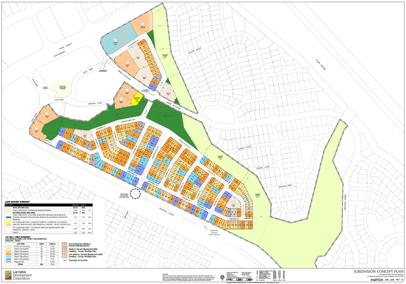
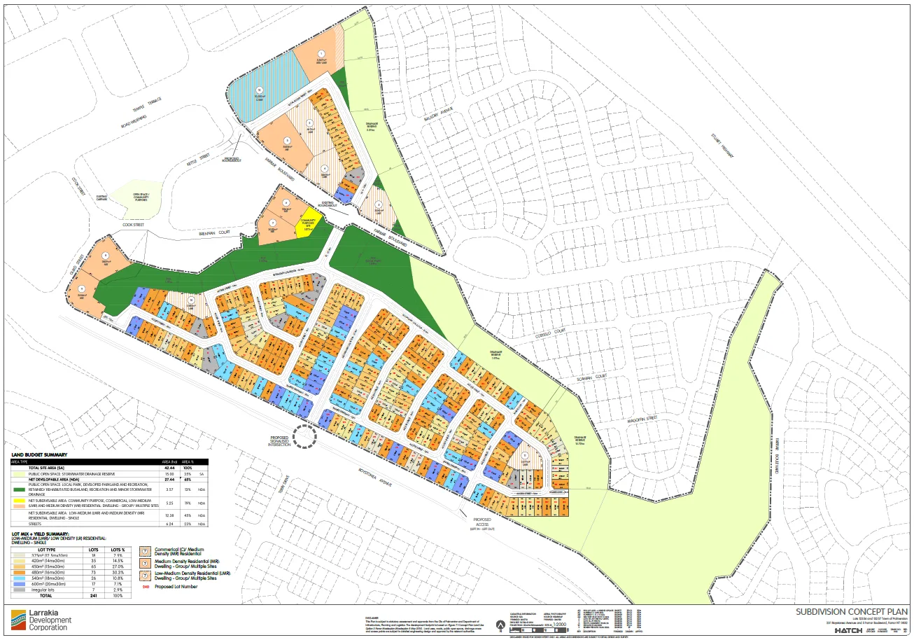
- Site Location: Lots 13256, 13257, and 13260 Town of Palmerston (231 Roystonea Avenue, 5 Farrar Boulevard, and 6 Gurd Street, Farrar, NT). PDF+ 1
- Site Dimensions: Total site area of 42.42 ha, comprising a 27.44 ha Net Developable Area and 15.06 ha in dedicated drainage reserves. PDF+ 1
- Proponent: Larrakia Development Corporation (LDC) / Cuttone Property Group under a Project Development Agreement with the Northern Territory Government. PDF+ 3
- Current & Intended Zoning: The land is currently zoned FD (Future Development). Stage-by-stage normalisation rezonings will establish Zone LR (Low Density Residential), Zone LMR (Low-Medium Density Residential), Zone MR (Medium Density Residential), Zone CP (Community Purpose), and Zone PS (Public Open Space). The commercial parcel will retain Zone FD to ensure future development is evaluated under the Palmerston Eastern Suburbs Area Plan (PESAP). PDF+ 4
Subdivision Yield & Lot Composition
The proposal outlines 263 total allotments delivered across seven primary stages:
PDF+ 2
- 241 Single-Dwelling Lots: Ranging from 363 m2 to 1,027 m2 (average area 497 m2). PDF+ 1
- 39 lots are ≥600 m2 (intended Zone LR). PDF+ 1
- 202 lots are 363 m2 to 599 m2 (intended Zone LMR). PDF+ 1
- 5 Low-Medium Density (LMR) Lots: Totaling 1.58 ha, designated for 2-storey grouped or multiple dwellings (~43 to 84 total dwellings). PDF
- 6 Medium Density (MR) Lots: Totaling 2.16 ha, located primarily near the Temple Terrace activity corridor for up to 4-storey development (~139 to 191 total dwellings). PDF+ 1
- 1 Commercial / Mixed-Use Lot: 1.0 ha allotment fronting Temple Terrace, intended for convenience retail, local services, food/beverage, and commercial space. PDF+ 3
- 1 Community Purpose Lot: 1,577 m2 site fronting Farrar Boulevard. PDF+ 2
- 6 Public Open Space Lots: Totaling 3.57 ha (13% of the net developable area, exceeding the 10% statutory requirement). Comprises a 1.39 ha active local park, 3 pocket parks, and a 2.03 ha linkage corridor. PDF+ 4
- 3 Drainage Reserves: Totaling 15.06 ha to accommodate realigned drainage channels and a regional flood detention basin. PDF+ 3
Environmental & Species Assessment
- NT EP Act Screening: EcOz Environmental Consultants’ pre-referral screening concluded that the project is unlikely to have a significant environmental impact under the Environment Protection Act 2019 and does not require formal referral to the NT EPA. PDF+ 1
- EPBC Act Listed Threatened Species:
- Typhonium praetermissum (Endangered): 222 plants were recorded on site. The layout retains ~48 plants (22%) in situ within the upper drainage reserve. The removal of 174 plants represents ~4.7% of the Holtze-Palmerston sub-population (and 1.4% of the total estimated species population), which was assessed as not compromising the long-term viability of the regional population. PDF+ 2
- Typhonium johnsonianum (Data Deficient): 2 occurrences recorded on site (1.4% of total NT Atlas records), assessed as low impact due to wide regional availability of suitable unmapped habitat. PDF
- Mertens’ & Mitchell’s Water Monitors: The local drainage channel offers marginal, degraded habitat; potential impact was assessed as low. PDF
- Northern Brushtail Possum & Darwin Cycad: Present on site; significant impact likelihood was assessed as low. PDF+ 1
Stormwater & Flood Management Strategy
- Catchment Hydrology: The site sits in the upper catchment of Mitchell Creek. PDF+ 2
- Channel & Infrastructure Works: Realigns existing pipe network outlets near the Farrar Boulevard roundabout into a new 20 m base-width grassed channel and installs a 7×1200×600 mm RCBC crossing under Farrar Boulevard. PDF+ 1
- Dry Detention Basin: Features a 24,500 m3 capacity dry basin (expanding to 54,500 m3 storage at 1% AEP peak water level RL 19.8 m) that merges the eastern and western flow paths. PDF+ 1
- Flood Impact Mitigation: WRM hydrologic/TUFLOW modelling confirms that the basin reduces peak 1% AEP off-site discharges by 13% overall compared to pre-development conditions (Roystonea Ave outfall reduced by 6%, Inverway Cct outfall reduced by 16%), eliminating off-site flood impacts on neighbouring properties. PDF+ 1
Traffic, Access & Servicing
- Traffic Generation: The development is projected to generate 4,833 daily vehicle trips and 469 peak-hour trips at full completion. PDF+ 1
- Intersection Modeling: SIDRA intersection analysis indicates that key external intersections (Roystonea Ave / Terry Dr and Farrar Blvd / Kettle St) will continue operating well within capacity 10 years post-development (Degree of Saturation max 0.83 and 0.19 respectively). PDF+ 2
- Road Hierarchy: Internal network incorporates Secondary Collector roads (21.6 m reserve), Access Streets (16 m reserve), and Minor Streets / Culs-de-sac (15 m reserve). PDF+ 1
- Reticulated Utilities: All allotments will connect to reticulated power, water, sewerage, telecommunications, and underground stormwater systems. Earthworks are structured across 3 bulk stages designed to achieve a balanced cut/fill on site without importing fill material. PDF+ 4