Contact your Local Member, the three City of Darwin Alderman and the Planning Minister. Should community be involved in planning decisions?
Councillor Amye Un This email address is being protected from spambots. You need JavaScript enabled to view it. 0499 382 948 Councillor Mick Palmer This email address is being protected from spambots. You need JavaScript enabled to view it. 0418 892 943 Councillor Sam Weston 0416 784 968 Hon Paul Kirby This email address is being protected from spambots. You need JavaScript enabled to view it. (08) 8999 6755
Below we have comments on the proposal, scroll down or click here.
Make a submission
You can make a submission by emailing This email address is being protected from spambots. You need JavaScript enabled to view it.
You must sign your uploaded submission to ensure that it is valid under the Planning Act. A valid signed submission includes a hand-signed document that is scanned and/or photographed; a name typed at the bottom of an email or uploaded document; or a JPG (or similar) of a signature placed at the bottom of the email or uploaded document.
Exhibition Period: Friday, 8 September 2023 - Midnight Friday, 13 October 2023
Address: Lot 01287 Town of Darwin 1 MONTORO CT LARRAKEYAH Lot 01288 Town of Darwin 2 MONTORO CT LARRAKEYAH Lot 01295 Town of Darwin 8 PACKARD PL LARRAKEYAH Lot 01296 Town of Darwin 7 PACKARD PL LARRAKEYAH
Current Zones: TC (Tourist Commercial)
Proposed Development: Readvertised with changes: 56 dwellings-multiple and 63 serviced apartments in 1x10 and 1x11 storey buildings plus three levels of basement car parking.
NOTE: there have been changes to the documents exhibited during the exhibition period. At this time PLan believe this is the correct list. More information as it comes to hand. 3/10/23 - DAS advise the website is now in good order the zip download matches the web site list.
Below here the documents are all 8 years old and should have no bearing on the current proposal. These documents are included in the proposal by the proponent.
There has been no attempt by the proponent to engage with community members to understand their concerns and gauge input to what is a contentious proposal.
The traffic review was carried out in 2019 and advises there has been no change in traffic conditions since that time. The time frame was during Covid, also there was no City Deal CDU campus or any Neuron scooters.
Development permits and drawings from 2013, 2014 and 2015 are attached creating confusion.
All traffic will be directed through Montoro Court and Packard Place with no consultation with the residents of those streets.
There is no setback from the Smith Street facing building, the land is public land, and the development should adhere to good planning. The interconnected network calls for an enhanced streetscape and landscape yet the building will be out of character with the other buildings facing Smith Street by adjoining the street reserve.
The proponent shows buildings on the other side of Smith Street as having no setback. This side of Smith Street has managed to preserve the road reserve and building setback from the road reserve throughout the development of the street. This would be a poor precedent and affect the site lines. To claim the reduced setback would be in character with Smith Street as it stands today is disingenuous. The claim that by allowing a reduced setback has generated an increased setback on other boundaries (above legal requirements) is irrelevant. It is assumed that planning regulations provide for appropriate building envelopes.
The tallest building nearby is 9 storeys, most of the buildings surrounding are 4 storey or less. Buildings of a height of 11 storeys are a significant outlier. Serviced apartments have a lesser floor space requirement allowing for higher density, these apartments have been sold into the investment and residential stock across Darwin over the years.
The act calls for Limited residential, commercial and community uses, such as dwellings-multiple, childcare centre and community centre, where the nature of the activity does not compromise the primary use of the locality for tourist commercial activities. This development is 47% declared residential and it can be expected the 53% Serviced Apartments will certainly mimic the residential uses of the site. The claim that the serviced apartments will be tourist use does not take into account the known student accommodation short fall in Darwin.
Planning Scheme - Tourist Commercial (in part, see nt-planning-scheme-part-4-zones-and-assessment-tables.pdf). https://nt.gov.au/property/land-planning-and-development/our-planning-system/nt-planning-scheme Zone Purpose Facilitate commercial and residential development that caters for the needs of visitors, supports tourism activities, and is of a scale and character compatible with surrounding development. The design, operation and layout of development: (a) makes a positive contribution to the locality by incorporating a high quality of built form and landscape design; (b) minimises unreasonable impacts to the amenity of surrounding premises; (c) mitigates the potential for land use conflict with existing and intended surrounding development; (d) avoids adverse impacts on the local road network;
This development is only residential, there is no retail/commercial/community facilities/urban open space.
The proponent claims to contribute to the amenity of the public realm with buildings that are clearly out of touch with the existing built form of the area.
The proponent claims to accommodate a range of demographic groups but offers no explanation of how this will be achieved.
The proponent claims a quality of landscaping without out any documentation as to the method of defining the quality. The drawings show street trees which do not exist and there has been no effort by any entity to promote the greening of the area. The proponent has shown no interest in the look and care of the site in the decades we have waited for an appropriate outcome.
Further the fact that the apartments will have sea views is purported to contribute to: Amenity, in relation to a locality or building, means any quality, condition or factor that makes or contributes to making the locality or building harmonious, pleasant or enjoyable. In fact, the buildings will decrease the amenity of those existing buildings with views as well as drastically change the nature of the two cul-de-sac streets.
The proponent claims that that the development is reasonably predictable. The term reasonably predicable is non sensical. It is reasonably predicable that it will rain before Christmas, what relevance is that to the planning legislation? This ignores that the community had a two-story motel with restaurant on the site for many years. The expectation of a like for like development would be reasonable.
There is no mention of tree planting to the Montoro Court to ensure an attractive site presentation.
The proponent calls for reduced balcony size on the one-bedroom apartments. This should not be permitted as it will create precedent. It is reasonable to expect that two people will live in the one-bedroom apartments and thus the legal requirement for private space should not be reduced.
Building articulation is not used on the internal facing walls. These walls will be visible from adjoining properties and street traffic. Please copy your comments to PLan on This email address is being protected from spambots. You need JavaScript enabled to view it.
This is the set loaded originally on 8 September 2023
Development is inappropriate in primary surge zone;
Where will services be provided from during storm surge?
Application doesn't demonstrate there is no link between anti-social behaviour in Stuart Park and the existing Ozanam House;
Impact on safety of other bus users;
No formal traffic assessment undertaken or provided, and should be required;
Ability for aging road and pedestrian infrastructure to cope with increased demand;
Concerns regarding potential for emergency vehicle access
Permanent facility should be developed elsewhere, with no need for interim option;
Proposed land use is incompatible with surrounding residential and commercial land uses;
Proposed land use is not appropriate in residential / commercial area;
Subject land is in close proximity to a number of premises with Liquor Licenses, including within walking distance of the Nightcliff BWS;
Subject land is 200 metres from supermarket and bottle shop;
Lack of Community Consultation;
Exhibition Signs were not noticed;
14 days is insufficient time to respond.
What measures are in place to provide transport, services, shelter and ensure security for / from users outside of operating times?;
Intended transport to where people are staying is contradictory to intention to provide service to homeless;
Clearing of native vegetation is not appropriate;
Will adversely impact local fauna species and reduce potential for vegetation to mitigate impacts from flooding and storm surge, including soil erosion;
Nothing in application to limit time period to 3 years.
Scepticism that proposed facility will be temporary.
City of Darwin, in collaboration with local architect firm Hames Sharley, have opened a stakeholder and community engagement process for the development of a masterplan for Bundilla Beach which will deliver a comprehensive plan for the area including short, medium and long terms goals.
Consultation closes at 11:59pm on Sunday 12 November 2023, with construction of the first stage of the masterplan scheduled for delivery in 2024.
It is of concern that the concept documents for stage one of the Master Plan are not to be found.
It is also of concern that the significant community consultation held in 2016 and the results have been ignored.
Note the use of Community Workshops and one-on-one discussions with stakeholders.
The consultation ran for eight weeks from 17 June to 12 August 2016 A community consultation process was carried out by Michels Warren Munday to hear from the community and stakeholders on their experiences, views and aspirations for the future use of Vesteys Reserve.
There were 405 online surveys completed, 45 written and verbal submissions, a community workshop with approximately 50 participants and one-on-one discussions with 19 stakeholders and local residents
The consultation findings have been categorised into three key areas: Knowledge and values, Issues and Future vision.
The strongest message from residents and stakeholders was that any future development on Vesteys Reserve must be in line with the current public open space zoning (so no residential or large scale commercial development), and that the public should maintain access to this valued open space.
To return to the current process
NOTE: At time of writing the advertised link to the Master Plan is broken, please email This email address is being protected from spambots. You need JavaScript enabled to view it. and This email address is being protected from spambots. You need JavaScript enabled to view it. requesting that the link be made good and an extension of time be granted due to members of the public being unable to access the document(s) under review. There is no available detailed description of stage one as far as PLan can tell.
Members of the public are concerned that this new masterplan is a takeover and is a most unfortunate development for the community. In order to prevent the commercialising of the foreshore, the community and particularly the local residents and independent other people, who use the foreshore, including members of the public, must continue to be strongly involved and speaking up. Apart from other issues, this area of foreshore should be full of natural variety so that it is a environmental asset for teaching by the two schools which adjoin it.
In the survey
Question 6 - where is the rational for the group of suggestions?
Do you think the following proposed deliverables designed for the immediate upgrade of Bundilla Beach meet your aspirations and needs? additional public lighting 3 x 3 basketball court greenspace irrigation additional BBQ tables and shelters street food enabling infrastructure additional toilets improvements to pathways improvements to parking a RV dump point.
1. Yes 2. No 3. Other (please specify)
Question 8 Now no mention of the RV dump Point, should members of the public be able to place it last if we chose?
Ok, they have paid $14k a year to hold 85 hectares of Lee Point for 16 years, it seems no one from crown land ever insisted the course should actually be built.
in 2020 members of the public picked up on the lease is up for renewal, so began enquiries. The answer from NTG was nope the lease holders will get the land, don't bother apply for the lease renewal.
The leaseholders have been meeting with members of the public explaining their plans for the site. We get 14 says to study over 400 pages.
Lee Point is now a national issue. DHA have not shown how they are meeting the original environmental requirements for that adjoining development.
To the golf course, at $1m per hole the course is a very expensive undergoing for a city with multiple golf courses. With global warming will people be playing golf in Darwin in 10 years’ time?
There is mention of a mini golf course as part one. Is it reasonable that NTG should only release that much land? The lease calls for the first 9 holes to be constructed in a year. When that is built then the next stage can be looked at. Meanwhile let’s rehabilitate the land. This area is known for attracting flocks of Gouldian Finches. We need extensive planting of Darwin bloodwoods for tree hollows.
115 ha
The subject land has the following areas and road frontages: • Lot 9461 - an area of 85.79 ha and a frontage of approximately 667 meters to Buffalo Creek Road. Access to the golf facilities on Lot 9461 will be provided from a section of the side boundary of Lot 9289 which faces onto Buffalo Creek Road (in the north-east corner of Lot 9289). • Lot 9289 - an area of 29.59 ha and a frontage of approximately 775 meters to Lee Point Road which provides access to the caravan and camping park and hotel development.
Current lease terms
DATE REGISTERED Commencement Date: 28 March, 2019 Expiry Date: 27th March, 2023 LEASE GRANT/PURPOSE Crown Lands Act (and the Regulations) The development of a Golf Course and any ancillary uses; Lots 9461 + 9289 Town of Nightcliff to create one lot (subject to 'the Act' the Lessee will not use the Land for a purpose other than the Lease Purpose). The Lessee must, within 2 years from the Commencement Date obtain necessary approvals, licences, consents pertaining to the NT Planning Scheme and Planning Act. Must within 4 years develop a Golf course (Certificate of Compliance?)
Lease terms over the years
CROWN LEASE TERM 973 Lot 9461 Town of Nightcliff from plan(s) S 93/239 Area under title is 85 hectares 7900 square metres.
23/07/2018 906760 Correction to Register - Tenure Status changed from () to (K) 13/04/2017 885984 Variation - term extended to 16/04/2018 21/03/2016 866549 Variation - term extended to 16/04/2017 17/03/2015 845394 Variation - term extended to 16/04/2016 19/03/2014 818300 Variation - term extended to 16/04/2015 26/03/2012 768257 Variation - conditions varied and term extended to 16/04/2014 12/12/2008 688161 Variation - conditions varied End of Dealings Commencement Date: 17th April 2007 Expiry Date: 16th April 2018
1. The purpose of the lease (the lease purpose) is 18-hole golf course, associated recreational uses and sewerage treatment ponds. 2.The annual rent for the lease (called the rent) will be $14,181.82 (fourteen thousand one hundred and eighty one dollars and eighty two cents) (GST Inclusive) subject to lease conditions 6,7 and 8.
2. The Lessee will within six months from the date of commencement of the lease or within such further time as may be approved in writing by the Minister for that purpose commence development of the first nine holes of the golf course in accordance with the lease purpose on the leased land to a value of not less than the sum of $1M (one million dollars) and the Lessee will complete the physical construction of the first nine holes of the golf course to a value of not less than the said sum within eighteen months of commencement of the lease or within such further time as may be approved in writing by the Minister.
3. The Lessee will within 18 months from the date of commencement of the lease or within such further time as may be approved in writing by the Minister for that purpose, commence development of the second nine holes of the golf course in accordance with the lease purpose on the leased land to a value of not less than the sum of $1M (one million dollars) and the Lessee will complete physical construction of the second nine holes to a value of not less than the said sum within thirty months of commencement of the lease or within such further time as may be approved in writing by the Minister. 4. The Lessee will within nine months from the date of commencement of the lease or within such further time as may be approved in writing by the Minister for that purpose, commence construction of the sewerage ponds to service the golf course and the caravan park and motel development on adjoining Lot 9289, Town of Nightcliff, in accordance with the lease purpose on the leased land and the Lessee will complete the construction of the sewerage ponds within eighteen months of the date of commencement of the lease or within such further time as may be approved in writing by the Minister. 5. The Lessee will within one year from the date of commencement of the lease or within such further time as may be approved in writing by the Minister for that purpose, commence landscaping associated with the development and the Lessee will complete the said landscaping within three years and six months of the date of commencement of the lease or within such further time as may be approved in writing by the Minister.
11. The Lessee shall in respect of the land included in the lease, ensure that at all times and to the satisfaction of the Minister, the land is kept clean, tidy and free of weeds, debris, dry herbage, rubbish, carcasses of animals and other unsightly or offensive matter and harbour for insects, pests and the breeding of mosquitoes.
Conditions Varied: LTO Instrument 688161 registered on 12th December, 2008 to existing conditions. Delete Condition 2 and replace with: "2. The Lessee will within one year from the date of commencement of the lease or within such further time as may be approved in writing by the Minister for that purpose, commence to erect improvements in accordance with Condition 1 on the leased land, to a value of not less than the sum of one million dollars ($1M) and the Lessee shall complete the erection of the said improvements to a value not less than the said sum by 16 April 2011 or within such further time as may be approved in writing by the Minister. Delete Conditions 3, 4 and 5. LTO Instrument 768257 registered on 26th March 2012.Variation to condition 2 by deleting "by 16 April 2011" and replace with "by 31 December 2013." Variation to condition 7 by deleting "within four years of that date" and replace with "by 31 December 2012." Variation to condition 8 by deleting "within four years of that date" and replace with "by 31 December 2012."
An 18-hole golf course in two stages and including a driving range, putting & chipping greens. b) Support facilities including pro shop, player amenities such as toilets, locker rooms, kiosk and future Golf Club House building (likely in stages). c) Maintenance and golf cart storage facilities. d) A Mini-Golf course including support facilities such as toilets, storage areas, outdoor seating dining areas, locations for food vans etc. e) Associated access and carparking areas.
Initial estimates of the project value including the development of Mini-Golf, Golf Courses, Pro-shop and Golf Clubhouse suggest a project value of approximately $20million. This will need to be confirmed once more detail is obtained.
The areas of the Site as proposed for this development application are zoned -Organized Recreation (OR). Refer Clause 4.18 NT Planning Scheme 2020 – extract below with associated definitions.
Features of the landscaping master planning for the site include: • The retention of the sensitive rainforest area in the southeastern corner of the site. • Revision to the original golf course layout to allow additional natural revegetation to the area adjacent to Dam 1 and along the southern boundary of the site to provide a wildlife corridor – an area where sightings of the Gouldian Finch have been made in recent years. • Significant areas of the site including areas between the proposed golf fairways with retained or generally naturally revegetated landscaping. • The retention of existing natural vegetation and revegetation with mainly natural species on the site to minimize the water requirement across the majority of the site. • Use of recycled effluent and harvested natural stormwater runoff of the site collected into the 3 dams and providing the source of water for the site irrigation – thus providing a sustainable water usage for the site.
The environmental provisions made within the golf course development for increased natural landscaping (trees and appropriate areas of grassland) – particularly on the southern side of the site and adjacent to the dam in the SW corner of lot 9461. Refer to the updated EMP in Appendix D and the Concept Landscaping Plan in Appendix G.
Bundilla Beach, previously known as Vesteys Beach, is an open, green space area of natural biodiversity with a large lagoon attracting a range of birds and wildlife on the edge of Darwin’s CBD. It is a peaceful place that attracts nature lovers, birdwatchers, local fishermen, cyclists, walkers and sunset viewers.
Hugging the foreshore it is linked via a public access concrete walking path to East Point Reserve on the one side and Mindal Beach on the other or via the beach at low tide.
Bundilla is a Larrakia language word meaning 'girl' or 'young woman'. On 20 March 2010 Vesteys Beach and a nearby creek, was renamed Bundilla Beach and Bundilla Creek respectively. The renaming to Bundilla recognises the continuing cultural significance of this site to the Larrakia Aboriginal people.
Vestey's Meatworks, officially the North Australia Meat Company, was a slaughterhouse in Darwin, Northern Territory, Australia, built by Vestey Brothers between 1914 and 1917. Never profitable, it operated for three years before the company abandoned the venture in the aftermath of the Darwin rebellion. Most of the facility was demolished in 1957, but two large water tanks remain standing today, on what is now the site of the Darwin High School on Bullocky Point in the suburb of The Gardens. The beach to the north of Bullocky Point is called Vestey's beach as a result of the meatworks. (Source Wikipedia)
This Petition is in response to the public announcement in April 2023 by the Lord Mayor of Darwin Hon. Kon Vatskalis, that he is planning to trial a commercially run RV Park on the foreshore of Bundilla Beach which is public land.
See below for images and more information.
Below is from the previous public meeting.
Darwin council is seeking public feedback on trialling a recreational vehicle park near Bundilla Beach (Vesteys Reserve) in Fannie Bay.
The consultation is online and closes 3 pm Friday 12 May 2023.
This is an abrupt about face on the use of this public space. In a recent survey community strongly indicated they were for preservation of the status quo in this area.
HOW CAN YOU HELP?
Visit the council site and read the Frequently Asked Questions, tell your neighbours and friends.
Local MLA Electorate Office – Hon Brent Potter and City of Darwin Counselors, Amye Un, Mick Palmer and Paul Arnold.
RALLY - Public Meeting Sunday 7th May 5:30pm at Vesteys Beach Car Park, all welcome.
Here are some of the items of concern:
Council says: We’re committed to working with local businesses and industry to advance the Darwin economy. Implementing this trial would provide more accommodation options near the CBD in Darwin’s busy 2023 peak visitor period and is expected to support local businesses, creative industries and the visitor economy.
How does this trial support creative industries?This type of accommodation was removed from the inner city area and NTG have allowed, with no apparent objection by Council, the closure of the Malak caravan parks which have been rezoned into residential. If we are committed to van life then why allow closure of existing parks.
Council says: There will be a dump point installed during the trial period with costs borne by the successful applicant. Recreational vehicles using the space would be self-sufficient regarding water, washing, showering, and cooking needs.
What is a dump point? Toilets/showers/Rubbish
Council says: A caretaker being onsite would be dependent on the operator’s processes. In other words there may not be a caretaker.
Who is ensuring good behaviour and that wildlife is not encroached on by dogs/cats etc. Will the booking system require restricted access to the space? How will residents be able to park and use the area for dog walking and fishing? Will access through to the High School be maintained?
Council says: The site for the proposed trial is currently being used as a car park and has a bitumen surface. Guests at the proposed RV park would need to have fully self-contained RVs, including showers, toilets and kitchenette. City of Darwin’s by-laws relating to illegal camping, litter, lighting fires, broken glass and animal management will apply. Should the RV park trial proceed and an operator appointed to manage the park, they will be required to obtain a Permit to Occupy under the City of Darwin By-laws.
What will be process for selection? What are the redress opportunities. The Neuron scooter trials have been going for years, is this how we deal with our community assets?
Council says: Should the trial proceed and be found unsuccessful, the site will be returned to its current state. Should the trial proceed and be found successful, further assessments will be undertaken to determine whether a long term RV Park is suitable.
All this is based on the outcome of a two-week online survey? Recently Council surveyed the people who rent car parks at Darwin Esplanade and based on those car park consumers response Council then abandoned the City Deal to green the car park. What number of survey respondents would be deemed a community approval?
NOTES PREPARED BY MARGARET CLINCH ON: A proposed (possibly initially temporary) 20 van caravan park backing Bundilla(Vesteys Beach now being promoted by the Lord Mayor.
A. The proposed area specifies the zones PS(Public Space) and OR (Organised Recreation) - NOT CARAVANS
B. Immediately below is an extract from the NT Planning Scheme Part 4, is the permitted ZONE and conditions for CARAVANS, ie. CV’s
4.8 Zone CV – Caravan Parks Zone Purpose Provide for the development of caravan parks that cater for short term tourist accommodation and long-term residents and their needs. Zone Outcomes 1. A mix of accommodation options such as caravan, tent and cabin accommodation and, where ancillary, hotel/motel and rooming accommodation. 2. Small scale convenience retail and tourism services for guests, residents and visitors, including bar-small, food premises (restaurant and café/take-away), shop, and recreation facilities, which support the main accommodation purpose. 3. Other development such as community centre, leisure and recreation and place of worship, that: 1. (a) primarily support the needs of the residents of a caravan park; 2. (b) are of a scale and intensity compatible with the character and amenity of the locality; and 3. (c) wherever possible, are co-located with other non-residential activities in the locality. 4. Buildings are low rise and generally do not exceed two storeys or a height of 8.5 metres. 5. The design, operation and layout of development: 1. (a) makes a positive contribution to the locality by incorporating a high quality of built form and landscape design; 2. (b) is sympathetic to the existing streetscape, scale and character of surrounding development; 3. (c) provides a high level of amenity; 4. (d) ensures that there is no unreasonable loss of amenity for surrounding premises; 5. (e) provides safe and convenient pedestrian and bicycle access within the development and strong connections to external transport networks; and 6. (f) mitigates the potential for land use conflict with existing and intended surrounding development. 6. Development avoids or minimises adverse impacts on ecologically important areas through location, design, operation and management of the use and associated nfrastructure.
An extract from the Northern Territory Planning Scheme 2020 Part 4-23 7. Development does not impose unsustainable demands on surface water and groundwater. 8. Subdivision primarily provides for lot sizes capable of accommodating the uses expected in the zone. 9. Subdivision and development is connected to reticulated electricity, water and sewerage (where available), stormwater drainage, and telecommunication infrastructure. 10.Development that is not defined in Schedule 2 (Definitions) may occur only when assessment has determined that the development is appropriate in the zone, having regard to the purpose and outcomes of this zone and such matters as the location, nature, scale and intensity of the development.'
General list continues here at C:-
C. The proposed caravans would absolutely clash with the established built environment of Parap and Fannie Bay, and its resident - clash of amenity. D. This area is no where near the CBD. E. An earlier attempt to place the ''Throb nightclub’ even for a short time at East Point, was rejected by the NT Governrnent. F. Atkins Drive is not built for heavier traffic. G. Management and supervision would be required onsite. H. Rubbish and sewerage would not be controllable I Other people wanting prior normal access and use of this beach would object. J. Day and night security would be insecure, including for alcohol, and food. K. Water, power and sewerage are not available on site. L. A further problem for the poiice force to attend. M. Control of wandering children, pets, and the impact on wild environment section near the bowls club. N . Soiling the beach. O. Lack of shade. Conclusion - Council has no true assessment of how much senior organisation and management would be required, even for a short time.
The following letter is being broadcast by the Mayor of Darwin.
Very concerning is the is the of "Commercial in confidence" (and not for the first time) by the Mayor in a matter that concerns all members of the community, why should information about our assets be withheld from us?
Another red flag is the claim that the City of Darwin owns the Esplanade. This is just not true, George Orwell’s 1984 never arrived here. The Community owns the City of Darwin and the City of Darwin acts in our benefit.
Thank you for sharing your concerns regarding the provisional heritage declaration of the Esplanade.
I would take this opportunity to share some additional information which may be useful, as follows:
Background
The land area encompassing the Esplanade is owned, managed and maintained by City of Darwin.
On 14 April 2023, City of Darwin was advised - at the same time as the broader public - that the Heritage Council had commenced the process to permanently list the Esplanade as a heritage place, and there was a 28-day period to make a submission.
It is prudent to authentic consultation and reasonable that City of Darwin's Council - as the governing board of the landowning entity - be provided sufficient time to discuss and debate the matter prior to coming to a resolution regarding the content of an official submission on the proposed declaration, which was not possible within the 28-day submissions timeframe imposed by the Heritage Council.
Further, in line with the Heritage Act, the Heritage Council is required to undertake an assessment of the heritage significance of a place within six months of the original application being received.
We understand the declaration, made in April 2023, followed an initial application that was made in November 2021, meaning it was more than 18 months since the application was lodged and therefore, according to the Heritage Act, the application was not valid .
In the initial stages, City of Darwin attempted to engage with the Heritage Council and NTG on this matter through non-legal avenues, but were advised we had no recourse and were required to make a submission within the 28-day notification period.
The invalidity of the process the Heritage Council took was confirmed by legal advice received by City of Darwin.
As a result, it was recommended that City of Darwin seek a declaration in the Supreme Court to recognise that the nomination had lapsed and should be discontinued, as well as to seek an order to prevent or postpone a future listing of this site.
Due to the legal nature of the case, it was also recommended that the accompanying documents and decision remained confidential.
Ramifications
A heritage listing over the entire Esplanade area means any uses of the site would require approval from the NT Government-appointed Heritage Council.
This means ongoing and accepted uses of the land, including those that the community would expect of parkland and open space, could be subject to an additional layer of review and approval from the NT Government (NTG).
Ensuring that due process is followed is crucial to City of Darwin because responding to a listing of this size, with a broad range of existing uses, would take time to research and compile, as would informing Council and seeking a Council resolution on the contents and direction of an official submission.
The proposed heritage declaration applies to the entire length of the Esplanade from Doctor's Gully to before the Deckchair Cinema, including some parcels of crown land and private property.
We are concerned that the proposed heritage declaration could potentially impact future activation of the Esplanade.
Activation of the site would improve the amenity of this much-valued community space.
We have reviewed the area under the proposed declaration, and it is largely City of Darwin land.
The application also ignores numerous other sites of cultural and heritage significance along the harbour. This includes a significant Larrakia women's site near the Deckchair Cinema, on NTG land, is not captured in the land subject to the proposed declaration. Further, sites of military history significance, including the wharf area where 45 people died during the first Japanese air raid of World War II, also on NTG land, are not included under the declaration.
We remain committed to implementing our 2030 Greening Darwin strategy, which aims to create a cool, clean and green city. The Greening Darwin strategy provides a framework for enhancing, preserving and protecting the natural environment of Darwin city centre through sensible, steady and continuous improvements. In line with this strategy, we will continue to work with all levels of government, the non-government sector and the community, to maintain and improve our public spaces, including the Esplanade.
The Esplanade is a valued public space in the heart of the Darwin city centre. City of Darwin acknowledges the significant cultural, historical, military, social and environmental value of the
Esplanade, and we want to make sure this valued space remains accessible to the community and supports community use.
I hope this helps alleviate some of your concerns. Yours sincerely.
Esplanade Heritage Listing - Public Meeting - Thursday 11th May 5:30pm at the Daly Street End of the Esplanade
The Heritage Council is seeking submissions as to whether The Esplanade should be declared as a heritage place under the Heritage Act 2011.
Submissions close Monday 15 May 2023.. This a critical step in protecting our heritage and open space from inappropriate development. There is publicly announced opposition to this listing from the Lord Mayor of Darwin. The listing omits a vital green zone which is part of the Esplanade. The road named The Esplanade is the original Esplanade defined.
STATEMENT OF HERITAGE VALUE The Esplanade is a large area of public open space bordering the Darwin Central Business District and overlooking Darwin Harbour. Aboriginal sacred sites and a number of historical features and significant memorials are located across landscaped, open parkland fringed by remnant rainforest.
The Esplanade is a legacy of the original 1869 Palmerston (Darwin) town plan and echoes town planning principles imported from South Australia. It represents a colonial cultural treatment of the landscape through the provision of planned, public space. Maintaining public rights to this green space has been the focus of continual public advocacy.
Lands encompassed by The Esplanade are of cultural significance to Larrakia Aboriginal people because of the presence of the Damoe-ra sacred site which is represented by a freshwater spring created by the actions of a Dreaming ancestor, the doemgilla trevally fish. The Larrakia lived on Lameroo Beach and The Esplanade until the powers of the Aboriginals Act 1910 saw them relocated to the Kahlin Aboriginal Compound in 1912. This site is therefore associated with the increased marginalisation of Aboriginal people from the town at that time.
The Esplanade continues to have high aesthetic significance and is a landmark feature of the city. The monsoon rainforest along the escarpment made for a memorable entry for boats entering the harbour and reinforced the identity of the tropical, harbour town. The remnant rainforest is one of a small number of important rainforest patches on the Darwin Peninsular which act interdependently to maintain biodiversity.
While the extent of The Esplanade has changed over time, it has remained true to purpose for more than one hundred and fifty years. Its multi-layered history gives it a unique place in the social and cultural history of Darwin. The fresh water springs that sustained the Larrakia people were appropriated as the earliest water sources for the town. Fruit and vegetable gardens planted around the springs at Doctor’s Gully were taken over by Chinese people, who worked them for many decades. ‘Greek Town’ was established above the Gully. Popular swimming baths were developed at Lameroo Beach in 1921.
Between 1882 and the 1950s, the Darwin Oval was the centre for sporting activity in the town with the earliest cricket and Australian Rules football games played there. The Oval has been the destination point for military, May Day and Bougainvillea parades and has been the location for significant events like Royal visits. Across time The Esplanade has been a meeting and gathering place for cross-cultural encounters, picnics, celebrations, music and cultural festivals, protests and political agitation.
The Esplanade was occupied by the military during World War II and the anti-aircraft guns positioned there are claimed to be the first to fire at attacking Japanese aircraft on 19 February 1942. Further military infrastructure developed on The Esplanade include five Naval Oil Tanks and the RAAF Catalina base at Doctor’s Gully, remnants of which still exist. The relocation of the Cenotaph to The Esplanade in 1990, together with the USS Peary Memorial, the ANZAC Centenary Memorial Garden and Walk, and the Civilians Memorial Entrance has seen The Esplanade become the major site for official military commemorations and tourist visitation. They serve as poignant reminders of the sacrifices made during wartime and of Darwin’s important role in World War II.
I have previously asked the Executive and Councillors of the City of Darwin at the open session: Who does the Lord Mayor speak for when he is in the public arena? Do his words actually match the opinion of Corporate City of Darwin or the wishes of the elected Councillors or the constituents who vote the Councillors in?
In the Katie Woolfe article the Lord Mayor advises he has his lawyers working against this perfectly reasonable proposal to consider the Heritage value of our precious Esplanade.
We feel the whole of The Esplanade should be included in the declaration. If you agree that the integrity of the green escarpment and defined by the Esplanade should be preserved, please ensure that you note this in your submission.
We are opposed to the adding of unnecessary conditions and inaccurate information to the proposal to heritage list the Kahlin Compound delaying the process.
PLan recommends that the whole of existing Lot 6364, Town of Darwin, covering the correct location of the Old Hospital Site Lot, remains un-subdivided, rejecting suggested new residential developments facing Kahlin Avenue, and the NT Heritage Triangle; and that the proposed red outlined 'Administrative Lot 11251, Town of Darwin Kahlin Compound/Old Hospital Site', be withdrawn, as the areas of the Kahlin Compound, and the site of the Old Hospital are not correctly geographically shown there.
Volunteer Required - Project Officer – Part time - reside in Australia
Overview
PLan: the Planning Action Network Incorporated Inc collaborates with resident and community groups on matters including the built environment, heritage, cultural and environmental values of concern in the Northern Territory and Australia. PLan’s aim is to achieve, for the community, sustainability in terms of social, cultural, environmental and balanced long term economic impacts.
Applicants would benefit from, but not necessarily require experience in:
Project management, document preparation and campaign management, town planiing studies
Attributes that would assist in you carrying out your duties:
A desire to influence change in the positive, a strong sense of place, capacity to enable community and an understanding of the history of the Territory’s built environment.
This position is unpaid and arrangements are by negotiation. A commitment to a minimum number of hours per week would be required.
Our office is located at Raffles, 8/1 Buffalo Court Darwin NT 0800.
For more information, please email at This email address is being protected from spambots. You need JavaScript enabled to view it. or call 0447 499 794
Under the guidance of the Convener the volunteer will:
Perform scans for information relevant to the organisations goals
Collate materials and prepare reports on gathered information
Prepare and enter materials into the online archive
Update internet facing assets
The volunteer will have the opportunity to participate in community and other meetings.
For more information, please email at This email address is being protected from spambots. You need JavaScript enabled to view it. or call 0447 499 794
Public meeting Thursday 27 May, 5.15pm at Lee Point
Darwin residents left the public meeting at Lee Point on Thursday outraged that the proposed housing development would harm nature and they were going to lose their enjoyment of Lee Point. Defence Housing Australia (DHA) has proposed to house thousands of people at Lee Point. Close to 100 Darwin residents attended the meeting.
.
Nick Kirlew and Margaret Clinch from Planning Action Network Inc (a volunteer community group) said that community consultation had not been properly done and as such the proposal to house thousands of people at Lee Point had very little community support. Mr Nick Kirlew said over 1000 people had signed the on-line petition which calls on the NT Parliament to place a moratorium on the current development proposal for Lee Point until the NT Planning Commission has developed a comprehensive Area Plan for the whole of Lee Point.
Ian Redmond from Friends of Lee Point (a volunteer community group) said that Lee Point is a part of Darwin that makes Darwin special, and that very few cities have a reserve like Lee Point on their doorstep. He believed that housing thousands of people at Lee Point was unnecessary, costly for the taxpayer and amounted to an urban sprawl. He also said that the DHA housing should be located near jobs and transport in line with the Australian Government’s Smart Cities Plan.
David Percival (Friends of Lee Point) said that Lee Point was Darwin’s most important environmental asset and needed to be protected. He believed the impact of housing thousands of people at Lee Point would destroy the surrounding environment forever.
Gavin O’Brien from BirdLife Top End said that the migratory shorebirds had already been partly affected by nearby housing development.
He explained how the way that human and canine disturbance can impact the roost and said that these impacts could increase with further development.
Martin Boland from Darwin Off Road Cyclists said that Lee Point was enjoyed by many cyclists because of its natural setting and had become particularly important during the time of COVID. He believed that cycling at Lee Point was good for mental health and that Lee Point should be conserved for public use.
Robert Marchant a long-term Darwin tour operator said he did not support housing thousands of people at Lee Point and it would not promote tourism in Darwin. He believed there were much better places to locate housing in Darwin and did not want to see a pristine forest destroyed.
Many people present at the meeting felt that most of Lee Point should become a conservation reserve and be used to help promote Darwin.
The (100) people present at the meeting called on the NT Government to stop the bulldozers until there is a comprehensive Area Plan in place for the whole of Lee Point.
CONTACT: Nick Kirlew - Planning Action Network 0447 499 794, Ian Redmond - Friends of Lee Point 0427 796 470
NORTHERN TERRITORY OF AUSTRALIA Planning Act - sections 54 and 55 DEVELOPMENT PERMIT DP19/0050 DESCRIPTION OF LAND THE SUBJECT OF THE PERMIT Lot 09370 Town of Nightcliff 544 LEE POINT RD, LEE POINT
APPROVED PURPOSE To use and develop the land for the purpose of a subdivision to create 282 in 5 stages, in accordance with the attached schedule of conditions and the endorsed plans.
VARIATIONS GRANTED Clause 11.2.3 (Lot Size and Configuration in Residential Subdivisions) of the Northern Territory Planning Scheme. BASE PERIOD OF THE PERMIT Subject to the provisions of sections 58, 59 and 59A of the Planning Act, this permit will lapse two years from the date of issue. DAWN PARKES Delegate Development Consent Authority Page 1 of 7 DEVELOPMENT PERMIT DP19/0050 SCHEDULE OF CONDITIONS CONDITIONS PRECEDENT 1. Prior to the endorsement of plans and prior to the commencement of works (including site preparation), amended plans are to be submitted showing: (a) A full set of amended detailed subdivision plans and other supporting reports and plans, reflecting the design changes made during assessment of the application, including the demonstration of compliant building envelopes where a variation to Clause 11.2.3 (Lot Size and Configuration in Residential Subdivisions) has not been granted. The above is to be completed to the satisfaction of the consent authority. 2. Prior to the endorsement of plans and prior to the commencement of works (including site preparation), the proponent is to prepare a Construction and Environmental Management Plan. The Plan is to address waste management, traffic control, haulage routes, stormwater drainage, and how Council land will be managed during construction, to the requirements of the City of Darwin. The Plan is also to address dust, noise and vibration impacts, and waste management, and include processes for: • communicating anticipated impacts of construction to stakeholders; • the reporting of, and responding to complaints; and • identifying when there are unexpected and unacceptable impacts to stakeholders and amending construction practices as appropriate, on the advice of the Environment division, Department of Environment and Natural Resources. The Plan must demonstrate compliance with NT EPA Noise Guidelines for Development Sites, and the NT EPA Noise Management Framework Guideline, and is also to include scope for regular review and updates and include the schedule for construction stages. The above is to be completed to the satisfaction of the consent authority. 3. Prior to the endorsement of plans and prior to the commencement of works (including site preparation), the design and specifications of the on-site collection of stormwater and its discharge into the City of Darwin stormwater drainage system or another acceptable location shall be submitted to and approved by the City of Darwin, Medical Entomology, Department of Health and Crown Land, to the satisfaction of the consent authority. The stormwater design should be completely free draining to avoid the potential for mosquito breeding during low flow periods. All discharge drains must be fitted with concrete low flow inverts that terminate at a free draining tidal area. Access to, and maintenance of the end of point discharge drains must be clarified and accepted by all relevant parties. The design of the stormwater infrastructure must consider the sub-staging of the development to manage the quality of stormwater. 4. Prior to the endorsement of plans and prior to the commencement of works (including site preparation), the developer is to prepare a water quality monitoring plan for Buffalo Creek, including baseline monitoring and monitoring of any additional pollutant loads from the subdivision, with any mitigation measures identified, on the advice of Water Resources, Department of Environment and Natural Resources, to the satisfaction of the consent authority. Page 2 of 7 5. Prior to the endorsement of plans and prior to the commencement of works (including site preparation), the developer is to prepare a weed management plan to address ongoing weed management, on the advice of Weed Management Branch, Department of Environment and Natural Resources, to the satisfaction of the consent authority. 6. Prior to the endorsement of plans and prior to the commencement of works (including site preparation), a landscape plan is to be prepared and must be generally in accordance with the landscape concept submitted, and is to address landscaping details for all proposed road reserves and public areas, to the approval of the City of Darwin, to the satisfaction of the consent authority. The plans are to demonstrate as little clearing as possible. 7. Prior to the commencement of works, an Erosion and Sediment Control Plan (ESCP) is to be submitted to and approved by the consent authority on the advice of Rangelands, Department of Environment and Natural Resources. The ESCP must be developed by a Certified Professional in Erosion and Sediment Control (CPESC) and should detail methods and treatments for minimising erosion and sediment loss from the site during both the clearing and establishment phases of the development.The ESCP should also: • be cross-referenced with other relevant environmental management plans to ensure consistency; • include details of both temporary and permanent erosion and sediment control measures including for all stages of the development (pre, during and post works); • comprise an over-arching strategic document outlining the principals, practices and methods to be implemented, as well as site-specific dimensional plans identifying the location of works and prescribed controls, and be accompanied by standard drawings and construction notes; • include information regarding the proposed timing and stage of works, site manager contact details, maintenance and monitoring requirements, and reporting procedures; and • have the implementation regularly monitored by a suitably qualified third party auditor. Information regarding erosion and sediment control and ESCP content is available at www.austieca.com.au and the NTG website: https://nt.gov.au/environment/soil-land-vegetation. The ESCP should be emailed for assessment to: This email address is being protected from spambots. You need JavaScript enabled to view it.. 8. Prior to the endorsement of plans and prior to the commencement of works (including site preparation), a site earthworks plan indicating finished levels of all proposed lots is to be submitted to and approved by the City of Darwin to the satisfaction of the consent authority. All cut and fill works are to be designed to eliminate the need for excessive cut/fill/retaining wall works for the proposed lots. 9. Prior to the endorsement of plans and prior to the commencement of works (including site preparation), the traffic impact assessment report submitted with the application is to be revised to address intersection priority and minimum collector street carriageway widths, to the requirements of the City of Darwin, to the satisfaction of the consent authority. 10.Prior to the endorsement of plans and prior to the commencement of works (including site preparation), public transport details including bus stop locations and designs, and a route that considers the staging of the development are to be provided to the requirements of Transport and Civil Services, Department of Infrastructure, Planning and Logistics, to the satisfaction of the consent authority. Page 3 of 7 11.Prior to the commencement of works, the developer is to submit an updated water and sewer infrastructure master plan to Water Services, Power and Water Corporation, to the satisfaction of the consent authority.The master plan is to address the development together with the related subdivision of Lot 4873, Town of Nightcliff to the west of Lee Point Road. 12.Prior to the commencement of works, a proposed zoning plan must be submitted to and approved by the consent authority. The zoning plan must be consistent with the description given in the application and is to address the whole of the subdivision including the proposed zoning for the end of point discharge drains. GENERAL CONDITIONS 13.The works carried out under this permit shall be in accordance with the drawings endorsed as forming part of this permit. 14.The development must proceed in the order of stages as shown on the endorsed plan unless otherwise agreed in writing by the consent authority. 15.The owner of the land must enter into agreements with the relevant authorities for the provision of water supply, sewerage facilities, electricity services and telecommunication services to each lot shown on the endorsed plan in accordance with the authorities' requirements and relevant legislation at the time. 16.All existing and proposed easements and sites for existing and required utility services must be vested in the relevant authority for which the easement or site is to be created on the plan of subdivision submitted for approval by the Surveyor General. 17.Any developments on or adjacent to any easements on site shall be carried out to the requirements of the relevant service authority to the satisfaction of the consent authority. 18.All proposed roads to be created on the plan of subdivision submitted for approval by the Surveyor General must be dedicated to the relevant Northern Territory or local government authority. 19.The Construction and Environmental Management Plan is to be implemented on the advice of the City of Darwin, and Environment, Department of Environment and Natural Resources, to the satisfaction of the consent authority.The Plan is also to remain publically available for the duration of construction. 20.Engineering design and specifications for the proposed and affected roads, street lighting, stormwater drainage, site earthworks, vehicular access, pedestrian/ cycle corridors and streetscaping are to be to the technical requirements of City of Darwin, to the satisfaction of the consent authority and all approved works constructed at the owner’s expense. 21.Before the use commences the owner must, in accordance with Part 6 of the Planning Act, pay a monetary contribution to the City of Darwin for the upgrade of local infrastructure, in accordance with its Lee Point Road Roadwork Contribution Plan, to the satisfaction of the consent authority. 22.Stormwater is to be collected and discharged into the drainage network to the technical standards of the City of Darwin, Medical Entomology, Department of Health, and Crown Land, to the satisfaction of the consent authority. Page 4 of 7 23.The applicant is to demonstrate all discharge drains, including the end of point of the drains, include suitable access to allow for maintenance on the advice of Medical Entomology, Department of Health, to the satisfaction of the consent authority. 24.The landscaping works shown on the endorsed plans must be carried out and completed to the requirements of the City of Darwin, and Medical Entomology, Department of Health, to the satisfaction of the consent authority. 25.All works relating to this permit are to be undertaken in accordance with the approved Erosion and Sediment Control Plan to the requirements of the consent authority on the advice of Rangelands, Department of Environment and Natural Resources. 26.The water quality monitoring plan for Buffalo Creek is to be implemented on the advice of Water Resources, Department of Environment and Natural Resources, to the satisfaction of the consent authority. 27.The weed management plan is to be implemented on the advice of Weed Management Branch, Department of Environment and Natural Resources, to the satisfaction of the consent authority. 28.Any offset or offset management plan required by the Australian Government with respect to the significant residual impact to the black-footed tree-rat (Mesembriomys gouldii gouldii) is to be completed, on the advice of Flora and Fauna, Department of Environment and Natural Resources, to the satisfaction of the consent authority. 29.A qualified person, under section 68 of the Waste Management and Pollution Control Act, must provide certification that the site is suitable for the intended use on the advice of Environment, Department of Environment and Natural Resources, to the satisfaction of the consent authority. 30.The proponent must ensure that only clean fill (virgin excavated natural material) is accepted and that the fill has been adequately assessed as being suitable for its intended use, on the advice of Environment, Department of Environment and Natural Resource, to the satisfaction of the consent authority. 31.Before the issue of titles, the developer is to provide written confirmation from a suitably qualified person that the rural residential lots are entirely unconstrained and free draining, and suitable for their intended purpose, to the satisfaction of the consent authority. 32.Before the issue of titles, the developer is to provide written confirmation (in the form of plans or drawings) demonstrating that all lots less than 600m² for single dwellings allow for future vehicle access via a single driveway unrestricted by street infrastructure (including any power, water, sewer, or stormwater infrastructure) which demonstrates that a 3.5m driveway can be located on each lot whilst ensuring that each lot’s street frontage has a minimum continuous length of 6.5m, to the satisfaction of the consent authority. 33.Pursuant to section 34 of the Land Title Act, a Caution Notice shall be lodged with the Registrar General on the parent parcel to include the following advice on all proposed lots indicated on the endorsed drawings to be located within the 1.7km odour buffer from the Leanyer Sanderson Wastewater Treatment Plant. The Caution Notice is to state that: “This lot: Page 5 of 7 • occurs within the identified odour buffer for the Leanyer Sanderson Wastewater Treatment Plant; and • may be subject to occasional odours associated with the operation of the Leanyer Sanderson Wastewater Treatment Plant.” Evidence of lodgement on the parent parcel shall be provided to the satisfaction of the consent authority. 34.Pursuant to section 34 of the Land Title Act, a Caution Notice shall be lodged with the Registrar General on the parent parcel to include the following advice on all proposed lots indicated on the endorsed drawings to be located within the biting insect buffer. The Caution Notice is to state that: “This lot: • occurs within the biting insect buffer; and • that the lot is subject to seasonal mosquito and biting midge pest problems arising from the adjacent mangroves of Buffalo Creek and tidal marshes and mangroves in Leanyer Swamp.” Evidence of lodgement on the parent parcel shall be provided to the satisfaction of the consent authority. NOTES 1. The Power and Water Corporation advises that the Water and Sewer Services Development Section (This email address is being protected from spambots. You need JavaScript enabled to view it.) and Power Network Engineering Section (This email address is being protected from spambots. You need JavaScript enabled to view it.) should be contacted via email a minimum of one month prior to construction works commencing to determine the Corporation’s servicing requirements, and the need for upgrading of on-site and/or surrounding infrastructure. 2. If you choose nbn to service your development, you will need to enter into a development agreement with nbn. The first step is to register the development via http://www.nbnco.com.au/develop-or-plan-with-the-nbn/new-developments.html once registered nbn will be in contact to discuss the specific requirements for the development. Nbn requires you to apply at least 3 months before any civil works commence. All telecommunications infrastructure should be built to nbn guidelines found at http://www.nbnco.com.au/develop-or-plan-with-the-nbn/new-developments/builders-designers.html. 3. The Northern Territory Environment Protection Authority advises that construction work should be conducted in accordance with the Authority’s Noise Guidelines for Development Sites. The guidelines specify that on-site construction activities are restricted to between 7am and 7pm Monday to Saturday and 9am to 6pm Sunday and Public Holidays. For construction activities outside these hours refer to the guidelines for further information. 4. Any proposed works which fall within the scope of the Construction Industry Long Service Leave and Benefits Act must be notified to NT Build by lodgement of the required Project Notification Form. Payment of any levy must be made prior to the commencement of any construction activity. NT Build should be contacted via email (This email address is being protected from spambots. You need JavaScript enabled to view it.) or by phone on 08 89364070 to determine if the proposed works are subject to the Act. Page 6 of 7 5. As part of any subdivision, the parcel numbers for addressing should comply with the Australian Standard (AS/NZS 4819:2011). For more information contact Survey and Land Records This email address is being protected from spambots. You need JavaScript enabled to view it. 08 8995 5354. The numbers shown on the plans endorsed as forming part of this permit are indicative only and are not for addressing purposes. 6. All new roads, including alterations and extensions to existing roads, are required to be named under the Place Names Act. You should immediately make application to the Place Names Committee to commence the road naming process. Contact the Place Names Unit on 08 8995 5333 or This email address is being protected from spambots. You need JavaScript enabled to view it.. 7. The Northern Territory Environment and Protection Authority has advised that the proponent must comply with their General Environment Duty provided by section 12 of the Waste Management and Pollution Control Act. 8. There are statutory obligations under the Weeds Management Act to take all practical measures to manage weeds on the property. For advice on weed management please contact the Rangelands division, Department of Environment and Natural Resources. 9. The City of Darwin provides advice regarding the provision of street trees to be planted within Council’s proposed road reserve, including the provision of a planting schedule, specification for quality tree stock, species selection, and the maintenance and establishment periods. Please contact the City of Darwin for advice on street trees. 10.Passenger Transport Planning, Department of Infrastructure, Planning and Logistics request that the developer remain in regular contact with the division and to confirm details of the location and design of bus stops as the development progresses. Page 7 of 7
Mitchell Park Botanical Gardens/Nature Park initiative
An effort to make the suburb of Mitchell and the neighbouring part of Litchfield Shire into a nature park/botanical gardens is getting started.
Meetings
Just a quick reminder that the first of the regular get together meetings will be at the Palmerston Library Community Room tonight from 6pm to 7pm.
Meetings are the 2nd and 4th Wednesdays of each month at this venue. Pass the word around.
Hope to see you there.
Kindest regards,
Jim Young
0439 776 025
A summary of the initiative and an explanation of how things might be structured is as follows.
At the end of the day the park would still come under the purview of the Councils, but management of the park would be substantially delegated to the park's organising committee in accordance with its constitution.
There will be some initial infrastructure that the local Councils would be required to provide.
The access roads and getting water reticulation to the areas needing irrigation, etc. would go in first. With good planning we can keep water usage to a minimum.
After this initial expense, from then on it would only require occasional maintenance. There would also be a need for some earthworks around areas requiring substantial landscaping, such as the swamps, ponds, etc.
Once this is done the volunteers can move in and help with the paths and gardening.
For certain tasks, volunteers might be required to complete an induction/safety course, which could be subsidised by the Councils.
Please appreciate that it is intended to have the vast bulk of the park remain effectively pristine bush.
The basic formula for how much of the park this is can be obtained by looking at the Zoning Map.
The green conservation areas will stay virtually untouched, except for access. The orange Future Development zoning area will remain at least 50% pristine bush.
Most of the park would be paths through the bush. Consequently these areas won't require much maintenance at all.
Another rule could be that not only does the orange Future Development zoning area remain at least 50% bush, but that there be no 'islands' of bush; no bit of bush is cut off from the other areas of bush.
The rest of the orange area can slowly, within means, be filled in with specific groves, features, and botanical gardens. The labour for this can be provided by volunteers, and any local company prepared to lend a hand, in exchange for being able to say they helped.
When things are ready, some raised walkways will need to be provided. Again, once done, these will only require occasional maintenance.
The footbridges over the creeks, especially the longer ones, would be expensive, and are a convenient luxury that wouldn't need to be part of the initial infrastructure. They can come in bit by bit many years later.
The mock up plan is only meant to give a basic suggestion of what it all could look like in 20 to 30 years time.
Once the initial infrastructure is in, it's time for the volunteers to move in. Volunteers will be given the opportunity to make and grow something that they can take a lot of pride in, to show and share.
The various groves and specific displays within the botanical gardens would have enthusiasts keen to help make it happen, now that they have the opportunity to showcase their passion on a large, impressive scale. There are many local enthusiasts of orchids, bromeliads, cycads, ferns, natives, crotons, palms, etc. around the Darwin area.
Birds and other native fauna should also be a major consideration during the planning process.
Many of the groves and displays could be a world class (or even world's best) example of that type of thing, and they would all be within walking distance of each other.
With planning and imagination we have the opportunity to make an urban nature park/botanical gardens for everyone to be proud of and enjoy for generations to come. Currently, under the heading 'Landmarks' on Palmerston's Wikipedia page, top billing is given to the water tank; albeit a lovely water tank.
Many benefits include
Conservation and availability of native habitat
Education – Primary to Tertiary, School excursions
Participation and pride
Tourism
Health – Bush walking/Jogging
Ideas for local gardeners
Adventure for kids a short bike ride away
But the window of opportunity to grab it is closing. If we don't act now it is destined to become a little bit more unspectacular suburbia down among the mozzies.
The Land Use Plans can be changed, especially if a popular effort demands it.
The indirect benefits to the two Councils once things are up and away need to be appreciated, too.
In the long run it will well and truly be a worthwhile investment.
Of course, there are many issues that need to be considered
Quarantine/noxious weeds
Littering/Anti-social behaviour
Emergency Vehicle access/First Aid
Bushfires/controlled burning
Fertilizers
Amenities/ablutions
Maintenance equipment storage
Sacred sites and WW2 heritage sites
So there is a lot to get organised. This is a grassroots effort, and it is just starting now. It needs people to get on board and help make it happen. We need to get the word out and about and start getting things organised. Once it's gone it's gone. Now is the time to get started!
If you would like to know more or get involved please contact This email address is being protected from spambots. You need JavaScript enabled to view it.
"On the 21 July 2020, the Lord Mayor received correspondence from the Chief Minister of the Northern Territory, stating that “as it is now clear that both the cycling community and local residents are very strongly opposed to the velodrome redevelopment project in its current form” and is requesting COD return an amount of $8M from the funding agreement for the Velodrome project"
Community interferes with COD project!
"Interference in the project from persons outside of COD and the NTG has resulted in a lack of clarity in the project deliverables under the funding agreement by both the Friend of Bagot Park and the Cycling community resulting in diametrically opposed views as to what the Confidential Ordinary Council Meeting Agenda 28 July 2020 Item 26.4 Page 7 project outcomes were to be. There is a risk that COD’s reputation as an organisation that is able to deliverprojects that meet with community objectives may be tarnished as a result of this interference."
Friends of Bagot Park are opposed to the NT Government and Darwin City Council’s plan to construct a Cycling Precinct on all of the existing vacant parkland in our suburban-based recreational park. The NT Government has funded the project at a cost $10.5m.
We believe that the park should be a great place to picnic, celebrate family milestones, get active and attend an event, a place that everyone can share and enjoy. Many residents purchased their homes in this area because they were drawn to the appeal of the open parkland space. We all need a space to take a breath.
Residents are confused, angry, frustrated and disappointed with not being involved in any part of the decision-making and planning process and want the park to remain as open parkland.
TAKE ACTION
We urge you to take action. Save your Bagot Park now and for future generations. Saving Bagot Park includes:
Locating the Velodrome and Cycle Precinct elsewhere
Rezoning all vacant land as Public Open Space
Developing a “Whole of Bagot Park Master Plan”
Resolving traffic and parking problems
Beautifying the park with mass planting of trees native to the area
Repairing and revamping verges with attractive landscaping
Engaging with Millner residents on future developments
Residents are opposed to the original concept plan that includes:
Rebuilt velodrome
Bike Skills flat track with jumps, ranging from 4m wide to 8m wide
Criterium (race) asphalt track, 3-metres wide with connection points to pedestrian paths, and
2-metre wide Pump Track with continuous loops and mounds.
Despite consistent efforts to gain information from the City of Darwin, we have not received formal acknowledgement or details of the plans other than the original drawing of the concept plan.
The main reasons for opposition to this project includes:
Neither a Feasibility Study nor a Master Plan for the park in its entirety has been developed
Traffic, parking and safety issues remain unresolved
Duplication of infrastructure for two major sporting organizations
Significant reduction of the entire open parkland
Little or no engagement with Millner residents, and
Bagot Park is an inappropriate park to be developed as a Cycling Precinct
The City of Darwin Council’s Functions and Objectives include providing for the interests and well-being of individuals and groups within the council area and to act in the best interests of the community as a whole. The NT Government also has a responsibility to respect the needs and aspirations of the constituents of the Millner community.
We need the NT Government and the City of Darwin to be accountable to their citizens.
BACKGROUND
Bagot Park is a large recreational park in Millner and provides an escape for the small pocket of homes bordered by Bagot Road and McMillans Road (major highways), Sabine Road and the service road of Old McMillans Road. Bagot Park is home to a local soccer club which uses the park on a daily basis and an existing velodrome in a poor state of repair.
Millner is an established, small suburb with many old Darwin residents, located 10 km from the city.
Adjacent to the football ovals and velodrome is open parkland which provides a buffer zone from noise and pollution from motor vehicles on McMillans Road, an arterial road leading to and from Darwin city. Part of this parkland is zoned as OR (Organized Recreation) and part PS (Public Open Space). Bagot Park is recognized and admired for its open space and shady trees which is reflective of its entry sign tagged, “Where nature and recreation meet”. People use the park as a place to wander and reflect, exercise, walk with their families, exercise their dog/s and enjoy the birdlife.
ZONING
The NT Planning Act states that development in Zone PS should be limited to that which has minimal adverse impact (if any) on adjoining or nearby property. Development of land in Zone OR is to be limited to that which is consistent with the recreational opportunities of the land. We believe that the proposed Cycling Precinct development of Bagot Park will have a major adverse impact on the adjacent residential area.
Old McMillans Road is a narrow service road and traffic congestion, parking and safety are major problems. Noise, pollution, night car lights, loss of park space, loss of huge old trees are other important but unresolved concerns. The unplanned sites for additional and duplicated buildings add to a visual mishmash of buildings within the same park. (Ref: Objection to the Proposal of the Development of a Bicycle Precinct at Bagot Park)
The zoning of the parkland needs to be changed to PS – Public Open Space where the land use is to provide areas for recreational activity for public use and enjoyment and which has minimal adverse impact on adjoining or nearby property.
The quality of our neighbourhoods, towns and cities has a significant impact on our daily lives. The open spaces of Bagot Park provide quality to the Millner neighbourhood.
FUNDING
NT Government has funded the project and is working in partnership with the City of Darwin who will deliver the project. In February 2020, the City of Darwin appointed a consultancy engineering firm, Cardno as Project Manager.
CONSULTATION
Pending a community consultation, the City of Darwin Council agreed in principle to the Cycling Precinct and, in April 2019, conducted a community survey based on the original concept plan. The survey comprised of yes/no questions with some room for comment. Friends of Bagot Park submitted a written and detailed submission outlining their reasons for their objections to the proposed cycling precinct.
Friends of Bagot Park analysed the survey results which indicated a heavy skew from cyclists’ supporting the cycling precinct. The result was reflective of a direct correlation with the larger number of cyclists’ respondents who used the velodrome, compared to the small population of people who live in the area. The City of Darwin reported an overwhelming response in favour of the Cycling Precinct. Further correspondence was submitted to the City of Darwin detailing the flaws and inaccuracies in the Consultation Outcomes Report. The majority of residents’ responses indicated that they did not want the Cycling Precinct to go ahead.
26th February 2020 Scott Waters, CEO, City of Darwin, email to Friends of Bagot Park: “Council officers are currently working with the procured consultant engineering firm to deliver detailed design as per the consultation that occurred last year. Once this has been completed stakeholder engagement will occur.”
Although both representatives of the NT Government and Council advised they would engage with the Friends of Bagot Park, apart from the original community consultation, neither the Friends of Bagot Park nor residents have been offered the opportunity to engage and discuss any plans involving the park development. We were only briefed on the Consultation Outcomes,
PLANNING PROGRESS TO DATE (as we know it) Since the early planning stages and the original concept plan on which the community survey was based, there appears to have been many changes to the proposed project. Despite Friends of Bagot Park ongoing questions and requests for more information, the residents of Millner still do not know what is to be included in Velodrome Project.
Infrastructure for the velodrome including an additional car park, an amenities block, grandstand, storage area and clubrooms are rumoured as future developments and, although not confirmed, the plans for the pump track and criterium track are part of the cycling precinct design and may also be included in the cycling precinct.
TRAFFIC AND PARKING PROBLEMS
Bagot Park is one of the home grounds for football in Darwin and is used on a daily basis. During the season, on competition days, the overflow from up to 400+ vehicles park wherever they can find space as the existing car park is too small.
Traffic congestion occurs on all neighbouring roads. Additional vehicles using the cycling precinct will exacerbate the traffic and parking problems. Residents do not believe that the Traffic Study Report accurately reflects several of the traffic and parking issues at Bagot Park. A discussion with residents about these issues would have gone a long way to a better understanding and reporting of them.
The identified need for additional parking would result in more parkland allocated to construct another car park. Construction of oval lighting for night-time training and football matches is in progress, intensifying the constant use of local roads. A concept plan has been presented to the City of Darwin showing an upgrade of the current car park with all the shade trees removed to create maximum parking places. Removal of trees to develop a hot bitumen car park adjacent to residences is unacceptable planning.
10th December 2019 Traffic Study and Road Safety Audit in Response to Velodrome Precinct Proposals: Author: Executive Manager Technical Service: Ordinary Council Meeting “According to the Capital Grant Funding Agreement (Agreement) for the design and construction of the Velodrome upgrades and lighting, the scope includes the construction of a new velodrome, bike skills area, club and facilities, storage, car parking and landscaping. “This assessment also confirmed that the car parking expected as a result of the proposed new developments in the area would exceed the capacity of the proposed new Old McMillans Road car park” “All of these roads are capable of accommodating to 3,000 vehicles per day so the current levels of traffic are comfortably accommodated” “There is therefore a potential parking shortfall on-site to the order of 26 bays. However, there is potential space on site to provide an additional estimated 30 to 40 angle parking bays along the future velodrome track which would result in the overall parking scheme being able to accommodate the total predicted parking generation.”
MASTER PLAN
For a park development of this magnitude and diversity, at a cost of almost $12m, there must be a Master Plan for Bagot Park in its entirety. The development of a Master Plan should involve all stakeholders including interested groups, representatives from the wider community, Friends of Bagot Park, sporting groups and other relevant stakeholders. There has been no Master Plan developed for Bagot Park despite the City of Darwin recognising the need for Master Plans in its Sports Field Plan 2016-2026, which cites under the heading of “Functionality Enhancements” p9:
“Develop Master Plans for individual sporting ovals”, and
“Ensure Master Plans consider opportunities to improve the functionality of each site.”
ADDITIONAL INFRASTRUCTURE
There are plans for significant additional infrastructure for Bagot Park. Current buildings include a public toilet and a kiosk for the Football Club. Plans are underway for the sport of football to construct, at Bagot Park, a “club house” with male and female change rooms, operations room, referees change room/storage area with confirmed Commonwealth funding.
Football NT’s planned infrastructure combined with the Velodrome plans for an amenities block, storeroom, an additional car park and a possibly a future clubroom and grandstand means unnecessary duplication of buildings within the park and does not reflect good planning. A Master Plan would have been in alignment with best practice and considered these infrastructure requirements along with any plans for future development of the park thus avoiding unnecessary duplication and ongoing frustration and dissatisfaction with ad hoc and poor planning.
CONCLUSION
BAGOT PARK IS AT RISK!
Open parkland will be filled with a maze of ugly 2 to 8-metre wide gravel and black asphalt cycle tracks. An additional car park and duplicated infrastructure will absorb our treasured park and become a blight on our open space.
Residents and members of the local community will no longer be able to enjoy the park as previously enjoyed.
The new velodrome with all the additional facilities and cycling elements belongs elsewhere.
Please help us to save Bagot Park now and for the generations to come by signing our petition "Save Your Bagot Park"
FOOTNOTES
NOTE Footnote links to be appended over next few days, please return to read
The following documents have been used to support our claims: 1. Velodrome Precinct Proposal – Community Consultation Fact Sheet City of Darwin 2. Objection to the Proposal of the Development of a Bicycle Precinct at Bagot Park 3. Response to Consultation Outcomes – Friends of Bagot Park: Letter to City of Darwin 4. Questions from Friends of Bagot Park: City of Darwin’s Responses 5. Traffic Study Report 6. Friends of Bagot Park Media Release 7. Friends of Bagot Park - Wants and Needs: Provided to Minister Lawler on Request 8. Letter to the Editor - NT News: Millner Resident 9. City of Darwin Sports field plan 2016-2026 10. Friends of Bagot park – Our position – given to Joel Bowden, MLA for Johnston Electorate 11. Photos of Parking 12. Photos of Bagot Park 13. NT Planning Scheme – Index of Zones 14. Bagot Park Action Taken Timeline
This campaign is about having land at Lee Point rezoned to encourage the efficient use of land, infrastructure and services for Darwin residents.
The land at Lee Point zoned as Future Development is next to biologically rich Casuarina Coastal Reserve (CCR) encompassing vulnerable/endangered wildlife, plants, and has internationally significant shorebird sites. CCR has over 1M visits each year and is increasing. This valuable asset produces revenue from ecotourism and could be expanded.
Rezoning the Lee Point land to Conservation means future defence housing would need to be located elsewhere. If for instance, Australian Defence Force personnel were located at Northcrest they would be much closer to work, have more frequent public transport, and not be exposed to biting insects or sewage pond odours. Taxpayers would find this more affordable because a lot of the infrastructure and services are already set up.
It’s your Lee Point – it’s your choice.
TO BE UPDATED - DRAFT FOR DISCUSSION PURPOSES - 6 July 2020
Improving the cost benefit of future defence housing in Darwin
Preliminary Assessment
Note: this is a draft paper and subject to change. It has been released early to assist with the “It’s your Lee Point” awareness campaign.
6 July 2020
Prepared by Ian Redmond and Gayle Laidlaw
(Darwin residents since the 1980’s)
EXECUTIVE SUMMARY
This preliminary assessment is in response to the proposed development of 800 houses (for 3000 people) by Defence Housing Australia (DHA) at Lee Point on lot 4873 and 9370. The assessment looks at the merits of locating future Australian Defence Force (ADF) personnel at Northcrest (near Berrimah Farm) and future rezoning of lots 4873 and 9370.
The scope of this assessment is limited in that it only considers Northcrest as an alternative site for housing future ADF personnel, and does not evaluate headworks cost, list relevant services for either Northcrest or Lee Point, eg education, health, recreation, retail, entertainment, which affect lifestyle, or consider different growth scenarios. Further work would be needed to better understand the costs and social benefits prior to engaging with stakeholders for both sites.
However, preliminary findings from the assessment indicate that future ADF personnel would be better and more affordably housed at Northcrest due to its central location, closeness to the major defence sites.
Similarly, there would also appear to be significant benefits in revisiting the best use of the Lee Point land having regard to the changes that have occurred since the use of this land was last reviewed in 2005.
Rezoning of the Lee Point lots 4873 and 9370 to Conservation (or similar use) provides a potential opportunity to reduce development costs (for the taxpayer), grow ecotourism in Darwin, and significantly reduce the environmental impact that would have come from the DHA’s proposed Lee Point housing development.
Background
Lee Point has played a role in a number of important historic events, such as the bombing of Darwin, the defence of Australia during World War Two and the Indonesian confrontation of the early 1960s. A radar station was located on lot 4873 (see map at Attachment B) until the early 2000s. The land is no longer used for military purposes.
Defence Housing Australia (DHA) is proposing to build 800 houses (for 3000 people) at Lee Point, refer to Appendix (Ref 1). The houses are to be built on lot 4873, next to Casuarina Coastal Reserve (CCR), and lot 9370. Based on the Notice of Intent prepared for DHA in 2015, (Ref 2);
Lot 4873, also called 2CRU (Lyons North) is owned by the Commonwealth, and
Lot 9370, also called Muirhead North is owned by the NT Government.
Lee Point lots 4873 and 9370 were included in the NT Planning Scheme in 2015 (Ref 3). A development application for lot 4873 was lodged by DHA to the NT Government in November 2017. It is not known how many houses are to be reserved for ADF members.
DHA is wholly owned by the Australian Government. Its main function is providing housing and housing-related services to members of the Australian Defence Force (ADF) and their families. (Ref 4).
Northcrest (168 ha), refer map below, is owned by Halikos Group, a Territory owned and operated business. Halikos Group has planned for 2000 houses plus a commercial development at Northcrest. The first land release (114 lots) commenced in March 2017 (Ref 5) and about 100 lots have been sold (5% of planned housing lots).
Darwin’s major defence sites (Ref 6), shown here in grey, provides the work place for most ADF personnel.
Sustainability
Sustainability is considered from three perspectives:
Social;
Environmental; and
Economic
for the Lee Point Development (LP) and Northcrest Development with defence housing (NC).
SOCIAL
NC and LP are less than 10km away from a major shopping centre, school, medical centre, major sporting complexes, boat ramp, and nature reserve. However, NC offers a greater choice of services eg restaurants, shopping and entertainment due to its central location.
NC’s central location would make it easier for ADF personnel to:
cycle to work (cycling to the major defence sites from NC was assessed as easy to moderate, and from LP as moderate to hard, refer Attachment A;
use public transport (frequent – and more cost effective - bus services are already available); and
visit the Darwin CBD and Palmerston CBD.
LP provides walking access to a beach in Casuarina Coastal Reserve (CCR). However, for LP; “The NT EPA identified a potential conflict of siting an urban development near an existing wastewater treatment facility, with potential for offensive odours to impact on future residents’ lifestyle and amenity. Similarly, potential health impacts to residents from proximity to breeding habitat for biting insects is also of concern.” (Ref 7, Sect Summary and Recommendations).
ENVIRONMENTAL
NC has minimal impact because the land was previously used for farming.
LP has a significant environmental impact. The inevitable introduction of more cats and dogs (predators) in the Lee Point region will threaten vulnerable or endangered wildlife species in the Lee Point area, such as migratory shorebirds, marine turtles, and Black Footed Tree Rat. Clearing of land will also threaten certain native endangered flora, and reduce wildlife numbers generally, refer Attachment B.
ECONOMIC
Economic sustainability relies somewhat on eliminating spending where it is not needed.
ABC News reported in February 2019 that Darwin ADF numbers had fallen by more than 25% since 2010 (Ref 8) and in March 2019 that Darwin’s 2018 population had declined by 0.2% (Ref 9). The issue of housing oversupply needs to be fully considered, particularly in light of the associated high cost of public infrastructure that is required for housing developments.
NC is partly developed with some headworks in place. It is expected to have lower costs (per lot) than LP due to its central location. However, these costs are largely unknown.
Attachment C lists potential costs and a possible use for the LP land (if it is rezoned).
Rezoning issues
Land Use Plans for any region are dynamic (not static), and should respond to changing circumstances: Darwin Regional Land Use Plan – Plan Purpose, 2015. (Ref 10)
Much has changed since the Lee Point Area Plan was incorporated into the NT Planning Scheme in 2015 (Ref 3). Darwin’s ADF personnel numbers have fallen significantly in the last ten years (Ref 6), and people are increasingly concerned about the environment, including the rate of greenhouse gas emissions and loss of biodiversity.
Risks of not rezoning the Lee Point land
CCR has internationally significant shorebird sites. The risk of not rezoning Lee Point is that CCR’s growing reputation could be diminished and residents find the Casuarina/Lee Point area less attractive to live in. Rezoning the Lee Point land supports the Australian Government’s Smart City Plan (ref 11, smart policy), and may lead to future funding opportunities with the Australian Government, refer to Attachment D.
Risks in rezoning the Lee Point land
The risk to the Australian Government of it not being able to use the Lee Point land (if it was rezoned and retitled), is non-existent because it has the power to override any Act of the Territory at any time. The loss of 800 house lots at Lee Point is not considered significant given the recent downturn in Darwin’s economy, and the potential to provide 2000 house lots at NC.
DHA has invested time and resources in planning a housing/commercial development at Lee Point which be lost if the land is rezoned.
Summary and Recommendations
Darwin needs long term jobs to sustain its population and improve its economy. The housing development at Northcrest (NC) appears to be more sustainable than at Lee Point lots 4873 and 9370 (LP) in all aspects; social, environmental and economic, due to its central location and closeness to the major defence sites. LP would be better rezoned to Conservation (or similar use) to promote ecotourism. However, these findings should be confirmed prior to engaging with stakeholders on the sites. The following work is recommended to confirm the findings:
Evaluate the cost of headworks (capital and recurrent) per lot at LP, NC and another site (if suitable). Indicative costs to meet the NT EPA Assessment Report 88 requirements at LP are to be included.
Assess the social benefits of living at LP, NC and another site (if suitable), from known services in the area, and list these services. Provide comment on what locations might best attract and retain ADF personnel.
Discuss various future growth scenarios for Darwin in relation to housing supply.
Comment on the environmental impact at LP versus NC, including greenhouse emissions.
ATTACHMENT A
Indicative travel times to Darwin’s major defence sites
The travel tables below were generated from Google Maps (Directions), and are provided here for strategic planning purposes only.
TRAVEL BY CAR
Car Travel
Darwin CBD Post Office
Larrakeyah
Barracks
RAAF Base
Defence Establishment Berrimah
Robertson Barracks
Palmerston CBD Post Office
Lee Point
20 min
(17.1km)
22 min
(17.7km)
15 min
(13.1km)
16 min
(12.2km)
19 min
(16.9km)
22 min
(21 km)
Northcrest
13 min
(12.6km)
16 min
(14.2km)
9 min
(8.5km)
6 min
(3.4km)
12 min
(9.6km)
11 min
(10km)
Difference
7 min
(4.5km)
6 min
(3.5km)
6 min
(4.6km)
10 min
(8.8km)
7 min
(7.3km)
11 min
(11km)
Notes:
Car travel times will vary according to traffic, ie. time of day and year.
Car travel from Lee Point to Darwin’s major defence sites ranges from;
In time: 15-22 min and is 6-10 min longer than from Northcrest.
In distance: 12.2 - 14.2km which is 3-9 km further in distance than from Northcrest.
TRAVEL BY BIKE
Bike Travel
Darwin CBD Post Office
Larrakeyah
Barracks
RAAF Base
Defence Establishment Berrimah
Robertson Barracks
Palmerston CBD Post Office
Lee Point
54 min
(17.9km)
56 min
(18.6km)
41 min
(13.9km)
42 min
(12.8km)
50 min
(17.1km)
67 min
(22.3 km)
Northcrest
41 min
(12.6km)
45 min
(13.5km)
26 min
(8.5km)
9 min
(3.1km)
29 min
(9.6km)
30 min
(9.5km)
Difference
13 min
(5.3km)
11 min
(5.1km)
15 min
(5.4km)
33 min
(9.7km)
21 min
(7.5km)
37 min
(12.8km)
Notes:
Google Maps tends to select bike tracks which can increase distance compared to car travel.
Bike travel from Lee Point to Darwin’s major defence sites ranges from;
In time: 41-56 min and is 11-33 min longer than Northcrest
In distance: 12.8 - 18.6km and is 5-10 km further in distance than from Northcrest.
Cycle to Work website considers cycling difficulty; 0-8kms as easy, 10-16kms as moderate, 18-24kms as hard.
Findings
Car travel from Lee Point to the major defence sites is significantly longer in time (6-10mins) and longer in distance (3-9km) than from Northcrest. Cycling to the major defence sites from Northcrest is considered to be easy to moderate, and from Lee Point moderate to hard. It is likely that more ADF personnel would cycle to work if they lived at Northcrest.
ATTACHMENT B
Lee Point Development
Dashed line shows the area to be cleared for housing and commercial purposes within Lots 4873 & 9370, it does not show actual lot boundaries. CCR is to west and north of this area.
Casuarina Coastal Reserve and protection of wildlife
The NT Government and City of Darwin has been running programs to protect wildlife from cats and dogs. With the proposed 800 houses (and more cats and dogs), protection of wildlife in CCR will become more difficult.
The Black Footed Tree Rat is classed as vulnerable in the NT and endangered nationally. Its numbers have fallen sharply in the NT since 2002 (Ref 12). Possible reasons for the decline include loss of suitable habitat and predation by feral cats. In 2017, it was photographed in Lot 9370 as part of the EIS process. The habitat shown on the left in the photo is considered to be good habitat for this species (Ref 13, Appendix M).
Photo of Lee Point Road (looking north), Lot 4873 on the left.
Black Footed Tree Rat (Wikipedia)
ATTACHMENT C
Headworks cost and future land development costs
The headworks cost at LP (for a population of 3000 people) could exceed $20M and needs to be better understood. Some headwork upgrades could have been carried out with the previous development of Lyons and Muirhead.
It’s likely that LP will require a new water storage facility, sewage pump stations, HV feeder, road and drainage works. In 2012, the City of Darwin estimated developer contribution cost for the roadworks from Muirhead to Lee Point would cost $4.1M. (Ref 14). There are possible upgrades to sewage treatment ponds and the electrical substation. The NT EPA (Ref 7, Recommendations) places stringent conditions on LP to reduce the significant environmental impact. It includes implementing a shorebird monitoring program, protecting marine turtles, stormwater discharge to tidal areas, cautionary notes to property buyers about biting insects, plus other requirements. This will increase costs at LP. There is increased car and public bus travel costs at LP compared to NC. None of these costs have been evaluated, nor has the greenhouse gas emissions (from increased car travel).
The headworks cost at NC (for a population of 7000) needs to be better understood. Some headworks have been carried out for NC as part of the first stage. It is likely that NC will have lower headworks cost per lot than LP due to its central location.
Ecotourism at Lee Point (to be updated)
One of the fastest‐growing tourism sectors is ecotourism (Ref 15). Casuarina Coastal Reserve (CCR) has over 1M visits a year and this number is increasing. A possible use for the Lee Point land (next to CCR) is ecotourism. It could involve walks showing wild food plants, aspects of aboriginal culture, bike trails, and defence history. While the area has some attractive woodland and a small rainforest, parts of it will need to be cleaned up (rubbish removed) and revegetated.
Larrakia Nation are the traditional owners of Lee Point. Section still to be drafted?????
Mountain bikers regularly use the LP area, and Darwin Off Road Cyclists (DORC) are already promoting mountain bike riding at Lee Point. There is currently a concept for a coastal trail (walking/cycling) from the CBD to Lee Point. The coastal trail, some of it already constructed, would pass by areas of interest such as the East Point Military museum. Lot 4873 could provide another “area of interest” on the coastal trail. Accommodation is available at the nearby Lee Point Village Resort.
For defence history, it would mean obtaining and displaying additional defence relics as many of the relics have been removed. Based on the NT EPA (Ref 7, Sect 5.1.2), lot 4873 contains the remains of a missile launching facility and explosives store, and remnants of anti-aircraft battery sites. Lot 9370 has the remains of a defensive gun pit.
ATTACHMENT D
Zoning of Lee Point land to attract investment (to be updated)
NT GOVERNMENT
In 2015, the NT Government released its Darwin Regional Land Use Plan (Ref 10) which included:
Key residential objectives:
Integrate new and existing residential development to maintain character and create a cohesive society that meets the diverse needs and aspirations of all sectors of the community.
Ensure sustainable development by encouraging:
○ the efficient use of land, water, energy and other resources
○ accessible and efficient public transport to reduce transport demands
○ cost effective provision and efficient utilisation of infrastructure and services
○ development that is consistent with the community’s economic, social, cultural and environmental values
○ the creation of character and identity
○ opportunities for community initiatives that support happier, healthier and inclusive communities
AUSTRALIAN GOVERNMENT
In 2016, the Australian Government committed to the Smart Cities Plan (Ref 11). The Smart Cities Plan provides a platform for long term investment and coordinated planning to help Australian cities reach their full potential.
In essence, the NT key residential objectives (see above) are not inconsistent with the Australian Government’s Smart City Plan. Issues such as the efficient use of land, accessible and efficient public transport, cost effective provision and efficient utilisation of infrastructure and services are common to both.
ZONING OF LEE POINT LAND
Rezoning the Lee Point land to Conservation (or similar use) encourages housing development at NC, an action which promotes the efficient use of land, infrastructure and services, and in turn supports the Smart Cities Plan. Developing in accordance with the Smart City Plan may help obtain future Australian Government funding under the Smart City Plan: City Deals initiative.
The NT Government and Australian government signed a Memorandum of Understanding in 2017 to work cooperatively together on City Deals. The first Darwin City deal was signed in 2018 and an implementation plan was produced on November 2019.
It seems to us that the City of Darwin (Darwin City Council) has veered off the rails in a big way. Many decisions that affect the assets of the City of Darwin are being taken in secret. The principal stakeholders, the rate payers of Darwin, are the last to hear of the latest asset disposal. In our opinion this is in direct contravention of the City of Darwin's mandate.
We wish to remind Council of their functions and objectives (including to provide services and facilities for the benefit of its area, residents and visitors, to provide for the interests and well-being of individuals and groups within the council area, and to act in the best interests of the community as a whole) when they are deciding how to proceed.
Quotes:
28 October 2019 COD in response to a PLan enquiry - Council is not considering any matters in relation to the RSL at this upcoming ordinary meeting. Council is considering a recommendation for Stage 1 of the Cenotaph Renewal, as part of funding received from the Australian Government. Can you please provide more detail in relation to your questions below, particularly when information was received and from whom?
18 February 2020 - The Darwin Film Society (DFS) is writing to you to outline serious concerns regarding proposed development in the vicinity of the cinema. A development of this size and nature, in the proposed location will cause severe disruption to the cinema. The City of Darwin will lose a major attraction for tourists and locals if the Deckchair Cinema is forced to close. Jeff Coulter, Chair of the Darwin Film Society
13 May 2020 - NT Independent quotes RSL President Steve Gloster said Darwin RSL was finalising a proposal to build a three-level venue on the site of the Cenotaph carpark at the edge of the Esplanade, featuring an underground carpark, ground-level café and a club area located on the top floor.
13 May 2020 - Darwin Mayor Kon Vatskalis has suggested relocating might be the best option for the iconic outdoor movie venue.
On the ABC at 7.30am+ on 25th May 2020, Chief Minister Michael Gunner said on air that the Esplanade was really not the right place for the RSL. His expectation was that a cool green open space would be established to allow for the large numbers who have been attending the Anzac Day events. This was as agreed previously.
The Public Esplanade was established by George Goyder in 1869, at the time of the first actual Survey of land laying out the Darwin plan (then named Palmerston).
It provides a large area of open space between the sea and the first line of lots for built development on the actual Darwin plateau above the escarpment from the sea.
In English Speaking communities throughout the world, it has been the custom and rule in planning to set aside such a green area for the free use and enjoyment of the ordinary people. Our Esplanade is consistent with this civic custom and should remain that way.
The Public Esplanade provides not just open space for general recreation, but also panoramic views of all angles of Darwin Harbour. The adjourning street, as in many Australian cities, is named The Esplanade.
In 1920/1, the importance and significance of this principle was reinforced when the Governor General issued a national proclamation, an original of which is in the National Archives, Canberra. It provides that there be no building on the Darwin Esplanade.
Our understanding of the roll of local government in holding open spaces not privately owned, is a custodial one – (held in trust). It is strictly that councils manage these lands on behalf of the public. They are not financial assets of each relevant council, to be leased to private entities, and certainly not sold, or ever alienated from the public.
People should be outraged that anyone should even suggest that such lands should be ‘commercially’ developed as ‘assets’ by council, as the current Lord Mayor Kon Vatskalis has done through the NT News recently. These are public assets for recreation in an entirely different sense and should stay public assets. Availability of areas of such public assets should be increasing as the Darwin population grows, and not be reduced.
There should be no building on the Public Esplanade.
The Darwin Cenotaph is not a building, but a Memorial to those men and women to whom we owe our own personal freedom. It is a very public place in a suitable green setting on the Esplanade.
The RSL (Returned Services League) has plans of building a large multi-million two storey building of modern design on the Public Esplanade, near the Cenotaph. It is said by them that it would have cafe, and possibly a museum on the ground floor, and RSL offices on the second floor, with a verandah at the side for views to the sea.
It is being emphasised by the RSL committee that it would need to be successful commercially, so poker machines (a feature of the previous RSL) would be expected. Those using the new facility would include veterans, but a majority of social paid up members and visitors would be expected as patrons.
The building is intended to replace the smallish two storey one with land, burnt down in Cavenagh Street. Considerable funds could be expected from is from insurance, and the sale of that land. There is also an unoccupied site with RSL Club Branch buildings in Batten Road, Marrara. This site is closer to the Northern Suburbs and Litchfield Rural Area where many RSL people live.
It is understood that the architect (Hully Liveris) asserts that his ‘business’ building, would especially suit the CBD (Central Business) zoning of the city area. However, this ‘CB' zoning of the city is not actually centred on business use, but on a mixture of uses. Such a commercial building, with bustling crowd comings and goings, is incompatible with the honest quiet solemnity of the nearby Cenotaph.
The definition of the NT Planning Scheme ‘CB' Zoning is given below, as a footnote.
It is being stated that the RSL building proposed is not to be on the Public Esplanade, but on the old Darwin Oval Carpark, now immediately adjoining one end of the Public Esplanade. It is known that the City of Darwin Council, following the construction of Parliament's underground carpark promised to ‘green’ this area, no longer using it as a carpark, and not wanting it for building. The original plan was that once the new Underground car park was built, all car parks around the Supreme Court, Parliament house and the Darwin Oval would be returned to green open space. Darwin CBD has an inadequate amount of open space and any further erosion of this must be opposed.
It is obvious from its position that this ex-carpark land was originally part of the Public Esplanade. It should be restored to it now, to properly take in a balanced Cenotaph, as a completed piece to the end of the Darwin plateau. Clearly Goyder did not establish this carpark, since there were no cars in 1869.
Such a big building built on the top of the cliff, would block the panoramic views of those enjoying the fresh air on the Public Esplanade, sitting or strolling, as individuals, and in groups of ordinary people.
Particularly, the building would block continuous views of vessels, large and small, entering and leaving the Darwin port. Children would be affected by the presence of a licensed club building on this site. The panoramic view would be destroyed.
The size of such a large new two storey building in this important corner of the Public Esplanade, would inevitably dominate and take away from the simple modest Cenotaph. This plain shrine has stood the test of time as a Memorial to the Territory Fallen. Its dedication reads: “This memorial is erected by the residents…”
The proposed siting of the building sits on land above the long-established Darwin Deckchair Cinema. Interests of this organisation have serious reason to believe that noise and lights from the proposed RSL Club would compromise their popular film showings. These have come to be major entertainments events in the Darwin Season. This open air not-for-profit cinema is now the only working cinema in the Darwin city.
All things considered; we are surprised that the RSL considers it appropriate to suggest that their new building be built on the Public Esplanade. It is best if the former Darwin Oval carpark, including the historic Darwin Pillar was immediately resumed into the Public Esplanade. No part of the Public Esplanade should ever be sold or leased for commercial purposes.
Footnotes:
DEFINITION OF ZONE CB-CENTRAL BUSINESS (as in the NT Planning Scheme (5.7) 1. ‘The primary purpose of Zone CB is to provide for a diversity of activities including administrative, judicial, professional, office, entertainment, cultural, residential and retail and other business activities with a commitment to the separation of incompatible activities.
2. Building form and design is expected to be sensitive to the needs of pedestrian movement, and facilitate the creation of safe and active street frontages and public places, and a vibrant commercial precinct.’
LOCAL GOVERNMENT ACT 2008 The Local Government Act 2008 also says that the sale of council land should be consistent with Council’s objective and should advance Council’s Strategic Plan (see part 6 of the Minister’s guidelines which are mentioned in section 182 of the Local Government Act 2008 https://dhcd.nt.gov.au/__data/assets/pdf_file/0013/37012/lga_guidelines.pdf )
For Immediate Release Media Contact: Cynthia Last 15th April 2020 Coordinator Friends of Bagot Park Mobile: 0439 626 730 Email: This email address is being protected from spambots. You need JavaScript enabled to view it.:
• $10.5million allocated to replace the Velodrome at Bagot Park
• Planned mass infrastructure will significantly reduce accessibility to open public green space hence, at risk of no longer being a recreational park
• Relocate the Velodrome and Cycling Precinct to a more appropriate sporting environment
The Friends of Bagot Park call upon the City of Darwin and the Northern Territory Government (NTG) to reconsider their plans to develop Bagot Park into a Cycling Precinct and to withhold any further decisions until a feasibility and environmental impact study is undertaken.
The City of Darwin received $10.5m NTG funding to build a new Australian National standard velodrome at Bagot Park. The new velodrome is designed to be the centrepiece of a Cycling Precinct, which will comprise a 780m x 3m concrete or asphalt criterium racetrack, a bike skills dirt track 4m to 8m wide and a 370m x 2m pump track.
Additionally, the City of Darwin Council has prioritised infrastructure projects for Football Federation NT and Mindil Aces Football Club to build facilities that include a clubroom with male and female change rooms, an operations room, referees’ change room and a storage area. To accommodate extra vehicles using the cycling precinct, an additional 30-40 vehicle car park is planned. Plans also depict the removal of all trees in the existing car park to provide a maximum number of car parking spaces.
A combined spend of more than $12m on facilities and buildings will result in the loss of open public green space and the loss of trees. Tonnes of concrete, asphalt and bitumen poured onto our green space will affect the health and wellbeing of everyone who enjoys the park for recreation and relaxation as the parkland is a buffer from traffic noise and pollution from two arterial roads. Furthermore, this development will have dire consequences for our resident wildlife and migrating birds as Bagot Park is a green wildlife corridor for seasonal visitors like Magpie Geese, Cockatoos, Goshawks and Curlews.
$10m is one-third of the NTG’s Coronavirus stimulus package for NT home owners and equivalent to costs incurred in building the Nightcliff Renal Unit, which is a lifesaving facility. In perspective, the tender awarded for the government-funded grandstand at the Darwin Turf Club was $12m, and, in consideration of our current economic climate, $10m would create 210 full-time jobs for COVID-19 unemployed persons.
The plan to change Bagot Park into a Cycling Precinct was not based on a feasibility or environmental impact study. The decision was based on the needs of NT cycling organisations. Friends of Bagot Park believe that these cycling facilities should be located in a more suitable, established sporting environment where NT Cycling organisations conduct National and International events, not in a green space valued by the Darwin community.
The Friends of Bagot Park Coordinator, Cynthia Last says, “A suburban park such as Bagot Park must provide open green space for the local and wider community to use for recreation and leisure activities. A place to exercise their dogs, enjoy family recreational activities and to have a pleasant safe place to walk and wind down after work. We want our park to be beautified with a shared path, verge planting, landscaping with trees native to the area and bollards to ensure pedestrian safety and to protect the verge.”
Please become a friend on our Facebook page, Friends of Bagot Park, and sign our petition: https://www.facebook.com/groups/2144134709163017/
END
Background Information
Friends of Bagot Park formed three years ago to promote, protect and enhance the environmental, cultural and aesthetic values of the area bounded by McMillans Road, Bagot Road, Old McMillans Road and Sabine Road at Bagot Park and surrounding parklands. We aim to promote the enjoyment and appreciation of Bagot Park by residents and the Darwin community.
We have been lobbying the City of Darwin and NTG for the past two years to consider a ‘Whole of Park Plan for Bagot Park’ so that activation and development of Bagot Park is aligned with the needs of the Darwin community.
A timeline of our lobbying efforts can be provided.
Also attached is a Concept Map for the Velodrome and elements for the Cycling Precinct.
Promoting, Protecting and Enhancing the environmental, cultural and aesthetic values of Bagot Park
In an underhand and secret tree cull workers were spotted felling 120 year old Milkwood trees in Darwin Post Office Car Park at 7am this morning.
One tree was down by dawn.
A small group of concerned residents attended site and managed to gain a halt the felling of tree two. According to ABC Radio police ordered the stay of execution due to pending heritage listing of the second Milkwood tree. The accompanying photo shows the World War two helmet embedded in the tree.
PLan: the Planning Action Network Inc are dismayed at the continued ignorance of our elected politicians to sanction such an attack on NT Heritage. The current Lord Mayor and Chief Minister were voted in on the promise of open government and protection of our heritage and green assets and this is the result.
The claim of an extra 500 hoped for international students for Charles Darwin University as the basis of a $150m loan to a university that is planning to demolish buildings on the current campus does not pass the pub test. This after Barneson Boulevard forever divided the Frog Hollow park heritage precinct.
Below we look at the statements we can find. Italics represent the articles as found.
Lord Mayor of Darwin Kon Vaskalis appears to contradict himself (see paragraphs nine and ten). Also he withdraws from Social Media.
The NT News article of 20 September 2019 is in direct contravention of the outcome. It would be good to know who the Darwin Council spokesman was.
National Trust statement after the trees were felled.
Statement from CDU, I am still trying to track down the original so treat with caution.
PLan offer the following thoughts:
It is clear that the process of spending big money to revitalise the city is failing community. Whether it will actually bring prosperity to us all is perhaps questionable also.
A halt on proceedings is required and true consultation should begin.
Respect for our heritage, our green space, our unique community and environs are mandatory for those who seek to manage our assets.
Consultation by press release and Facebook post does not cut it with Territorians.
Events
12:15 Wednesday 18/12/19
The first one will be at 12.15pm, Wednesday 18th December hosted by Gerry. This will allow people to come down at lunch time to show they cared about the tree as opposed to our civic leaders. There will be a plaque put in place near were the old tree once stood and a new tree planted to replace the old one. The ceremony will be short because of the heat. Please wear something bright as this is a celebration of a grand old tree and the beginning of a new one. Also wear a hat. Ring Gerry Wood for more details 0428698037.
The second gathering will be hosted by Taste of The Top End and Darwin Community Arts. They will have small Milkwood trees for people to take and plant in areas that will not be developed. The ceremony will also be on Wednesday, 18 December 2019 from 17:00-18:30pm.
Lord Mayor of Darwin
This quote from the Lord Mayor of Darwin, see paragraphs 9 and 10 (our emphasis) which appear to be opposing statements (Facebook 15/12/19.) A bit of a bet each way.
I have followed with great disappointment and dismay recent Facebook posts regarding the removal of the Milkwood trees at the proposed new Charles Darwin University (CDU) campus on Cavenagh Street.
It is obvious that some people will resort to misinformation, personal attacks and name calling to suit their narrative ignoring facts and truth.
So let's get the facts right; the real facts and not the fake news:
CDU, the Northern Territory Government and the City of Darwin Council jointly applied and achieved a Darwin City Deal; one of the best in the country.
Under this City Deal, the Federal and NT governments will provide funding to CDU for a new campus in the middle of the city - a project that will revitalise the Darwin CBD. As part of the City Deal, the Council will provide the Cavenagh street car park for the new campus site.
CDU received a Northern Australia Infrastructure Facility (NAIF) loan of $150 million for this new campus. Similarly, as part of this City Deal, the Council has given the right to CDU to do works in the site for the construction of the new campus.
CDU has already completed geo-technical to establish the suitability of the ground and has proceeded with detailed planning of the new campus.
The advice to CDU from engineers and architects was to remove the tree.
“Following consultation with Larrakia Nation, it has been agreed unanimously with CDU, City of Darwin and the Northern Territory Government to remove two milkwood trees to enable the transformation of the car park into a world class education and civic precinct,” a CDU spokesperson said.
SO THE FACT IS THAT the milkwood trees were removed by CDU on the advise of their experts and NOT by the City of Darwin Council.
Following advice by CDU, the City of Darwin Council enquired with the Aboriginal Sacred sites and indigenous groups but no indication of importance was identified.
The City of Darwin Council does not and will not remove trees unless there are good reasons (ie safety of people and structures, power lines, playgrounds etc). On the contrary, the City of Darwin Council has embarked on a rapid reforestation of our city with 7000 trees planted by the end of December this year and many more to come in the next two years. This was somehow missed by the people who put upload postings in Facebook - and this is a fact!
I have spoken to the CDU Vice-Chancellor, and I believe that CDU will provide information regarding the removal of the trees.
As I have stated before, it is sad that people will rely on social media for inaccurate information and not search for the real facts.
I responded personally to people who have contacted me seeking the truth but after this debate has fallen to such a low level, I will not respond any more. It very sad that people will resort to personal attacks and foul language in their posting.
I invite you all to check the facts and not social media postings!
NT NEWS September 20, 2019 7:11am
WILL ZWAR, This email address is being protected from spambots. You need JavaScript enabled to view it., NT News
Subscriber only
A HERITAGE listed milkwood tree will be protected by its strict conditions while the future education and civic precinct is developed
A Darwin council spokesman said Charles Darwin University had found possible culturally significant elements of the milkwood tree, during geotechnical investigations of the Cavenagh St carpark site, where the trees are located.
“During CDU’s site investigations, which are required to inform the development of the site, it was found that there is the existence of some groundwater, soft soil confined to one corner and milkwood trees that may have cultural significance,” she said.
“To confirm the status of the milkwood trees, City of Darwin has undertaken to work with the Larrakia to determine cultural significance and an appropriate approach.”
It comes after independent Member for Nelson Gerry Wood said the milkwood tree, estimated to be more than 100 years old, hadn’t been addressed by CDU in the campus’ design, unlike the nearby boab tree.
But it has not been neglected forgotten about in planning for the site and will be preserved during construction of the new precinct.
“The historical and heritage-listed Boab Tree on the site has been known to the City Deal parties since the announcement of the project and will be protected in accordance with its strict conditions as part of the development,” the spokeswoman said.
“City of Darwin is looking forward to finalising the implementation plan with all parties and delivering on the Darwin City Deal.”
Darwin council, CDU and the NT Government will determine the best approach for the development of the site over the coming weeks.
National Trust Tim Dixon Statement on the Milkwood Trees
The National Trust has received many enquiries about the milkweed trees chopped down by Charles Darwin University on the weekend.
I can confirm the trees were on the National Trust Register of Significant Trees. They were listed in 1986 and recorded as being planted in the 1880s.
The Register has no legal power of protection of the trees - it is simply a recognition of trees which are important and significant to the Northern Territory.
More concerning is that Charles Darwin University removed the trees after they were nominated for heritage protection, as a way of perverting the Northern Territory's heritage protection system.
If other developers see what Charles Darwin University has done and if it is without consequence, then they might be encouraged to also bulldoze or destroy buildings of potential significance before they have the opportunity to be assessed. We regard this as an unacceptable gap in the system of heritage protection.
Therefore, the National Trust will be lobbying the Heritage Council, and through them Minister Lauren Moss, to amend the Heritage Act so that this wilful destruction is not encouraged in the future.
Many people have compared this to the destruction of the Hotel Darwin - in many ways, that’s a fair comparison.
Owners and developers from all around the Northern Territory accept and acknowledge the system of heritage protection and work within it. It is only a very small proportion who actively try to abuse the process, or who rush destroying the Territory’s heritage to evade the system that every other developer goes through. It is very disappointing that Charles Darwin University, funded from our taxes, is in this small proportion of bad faith operators.
In the meantime, we will regretfully go through the process of removing the trees that Charles Darwin University cut down from the Register of Significant Trees.
Tim Dixon, Director
This is the post by Charles Darwin University not seen in the original
We would like to acknowledge community concerns around the removal of two milkwood trees on the site of the Education and Civic precinct in Darwin CBD. While it was not an easy decision for any of the partners involved, it was essential for the project to proceed.
The heritage-listed Boab tree on the site had top priority for preservation and following extensive independent planning and third-party assessments, it became clear two milkwood trees would need to be removed to accommodate the new precinct at the site. Consultations were held with Larrakia Nation, and a formal assessment sought from AAPA and no significance was registered for this site nor for these trees.
Cuttings of the large milkwood tree have been taken and will be grown out so a direct connection to this tree can be maintained. All stakeholders have agreed to a significant replacement planting program in conjunction with Larrakia and other interested parties.
This $300 million (+) project has four key parties involved: the Australian Government, the NT Government, the City of Darwin, and CDU. The project partners agreed that preparation work at the site would begin as soon as Northern Australia Infrastructure Facility (NAIF) funding was secured.
The requirement for tree removal was included in information distributed to media and other interested parties at the NAIF announcement on Wednesday last week.
WARNING! SAY NO TO TAKING THE COMMUNITY OUT OF THE PLANNING ACT - new closing date
It is intended that the Planning Act will be significantly amended early next year and we only have until 6th December 2019 (was 29th November) this year to make our submissions.
This can be done at https://haveyoursay.nt.gov.au/planningreform or better by email: This email address is being protected from spambots. You need JavaScript enabled to view it.
Before you do though please read on:
You can find out more of this ‘consultation', with documents setting out, in detail, what is proposed, for downloading, and/or reading at the above site.
The stated aim is 'better planning', but much of what is proposed is about reducing the community’s role, even more, in planning decision making for our future.
You may ask: Would the changes mean better planning for the community? What will be lost? Should you know more about the Planning Act, its regulations, and the NT Planning Scheme, before you make your submission? Keeping in mind, importantly even the concept of “amenity” which is in the current Act, does not appear in the Purpose and Objectives of the new Bill.
Amenity is a crucial part of Planning that affects us all. Parking and Road Use, Noise, light pollution, privacy. late night activities, dust, smells, etc.
Where are the Section 2A Clauses referring to Amenity which the Development Consent Authority(DCA) must consider currently? Those things which can affect our lifestyle and the value of your property. How our streetscapes look, and how they support everyday community life and wellbeing.
Notifications are to be withdrawn from the newspaper for certain developments, this may well mean more community members will miss the chance to find out what is happening in their environment.
There is still no equality in planning appeals. Is the DCA independent? Ministers can still override decisions like zoning and some other matters without appeal, with Exceptional Development Permits still be permitted.
The act endorses strategic plans, area plans and policies that don't exist.
NJK
To find out more, and to help make your submission, read below
INTRODUCTION
The Northern Territory Government is asking for our community comments on its proposals for amending the Planning Act, 1999.
We need a balanced Planning Act which satisfies the wellbeing of all Territorians. This is what people asked for at the last election.
Instead it appears that there are to be a series of long term strategic plans which the Minister can control, and must be complied with without end date.
The media tells us there will be 50% population growth in the CBD, and a further 50% in the green areas around.
At present the Planning Act favours developers by promoting tall buildings, and crowded residential estates, with small lots. What is proposed would make it worse.
As if to signal the all importance of strategic planning, ‘AMENITY’ has been OMITTED as CLAUSE (e) at Section 2A (Objects) from the new Planning Act, with STRATEGIC PLANNING inserted three times for the development of the land. THIS WOULD THEN BE ABLE TO OPERATE AS A DEVELOPMENT ACT, NOT A PLANNING ACT.
WHAT DO WE NEED NOW THAT WE HAVE NOT HAD BEFORE:
Instead of this, residents need a new balanced Planning Act catering for good amenity in well planned;
1. Urban, Suburban, Rural and Remote Living for all domestic categories with suitable climate and culture architecture. (Towers are not suitable for families in the tropics)
2. Green trees and grassed parks in proportion to the growing populations.
3. Publicly owned Community social and cultural facilities, close to residential areas, eg youth centres, community centres, churches, schools, etc.
4. The Conservation of natural environments, particularly foreshores, catchments and other common law features.
5. Priority protection of places of heritage significance, whether or not listed.
6. The public should have a One STOP SHOP equivalent to the DEVELOPERS, and there must be pathways for public assignment of land.
MOST IMPORTANT IS ADDING IN YOUR SUBMISSION THAT THE WORD “AMENITY” BE PROMINENTLY IN THE NEW ACT IN THE EQUIVALENT PLACE AS SECTION 2A(OBJECTS) IN THE OLD ONE.
WHAT ELSE CAN BE DONE ?
There may be a few items you can add a comment about, from the list below:
Please use your own words
AMENITY SHOULD FEATURE PROMINENTLY IN THE NEW PLANNING ACT IN SECTION 2A (OBJECTS)
Section 51 which the DCA MUST consider, should be spelled out in full in the draft document, so people can see its purpose.
The massive emphases on strategic planning are counter- productive. The projections are too far into the future to be accurate, and do not have community acceptance.
Strategic plans are based too much on commercial activity centres, which may never happen.
Inadequate provision for local parks, community centres for old and young with a growing population.
Inadequate protection for urban and suburban natural environments, animals and birds.
Respect common law rights on foreshores and in catchments.
Need integration of social infrastructure for health and to avoid crime. Pathways for social infrastructure are needed.
No two level changes for advertising. This could cause more rather than less problems.
The public is tired of being hectored again and again over the years, and its needs ignored.
DAS and DCA procedures must be fair, and consistent.
No variations in development assessment..
The community must have equal status with developers.
Zoning is the basis of better planning.
Tropical areas need tropical architecture
Larger homes are needed for families.
Too much reliance on technology which is not always available.
Official announcements and advertisements MUST be by NT Press, and not just on websites, or other computer devices alone. Mail must be used when essential.
No let off for abandoned stockpiles, holes in the ground, or failures to comply.
Darwin has enough tall buildings - safety and fires ?
No more community purpose land sold to developers.
NO MORE illegal Exceptional Development Permits.
Greater equality in third party appeals.
NTCAT to function as a Tribunal not a court.
Better documented applications for Planning Scheme Amendments.
Proper definition of ‘MAJOR PROJECT' status when Minister’s special power is used
Phasing out of NT Planning Commission when all Local Area Plans established.
Local Area Plans to be INDICATIVE - Ministers could veto all proposed zone amendments as non complying- inflexible over years.
DCA Conflict of Interest needs clarifying.
Just process at DCA Hearings. No DCA recommendations before submitters speak.
SUBMISSIONS NOW CLOSE FRIDAY, 6 DECEMBER, 2019
MAKE SURE IT HAS YOUR NAME AND ADDRESS
Best to ask for acknowledgement.
SEND YOUR SUBMISSION BY EMAIL. USE THE ADDRESS - This email address is being protected from spambots. You need JavaScript enabled to view it.
MAC
For more information.
Regards,
Nick Kirlew
Convener PLan: the Planning Action Network Inc
0447 499 749
This email address is being protected from spambots. You need JavaScript enabled to view it.
Our valued volunteers man the office Thursday afternoon between 1pm and 5.30pm. We are located at 8/1 Buffalo Court, Darwin.
Contact
Post: GPO Box 2513, Darwin, NT, 0801
Phone: 08 8927 1999
Email: This email address is being protected from spambots. You need JavaScript enabled to view it.
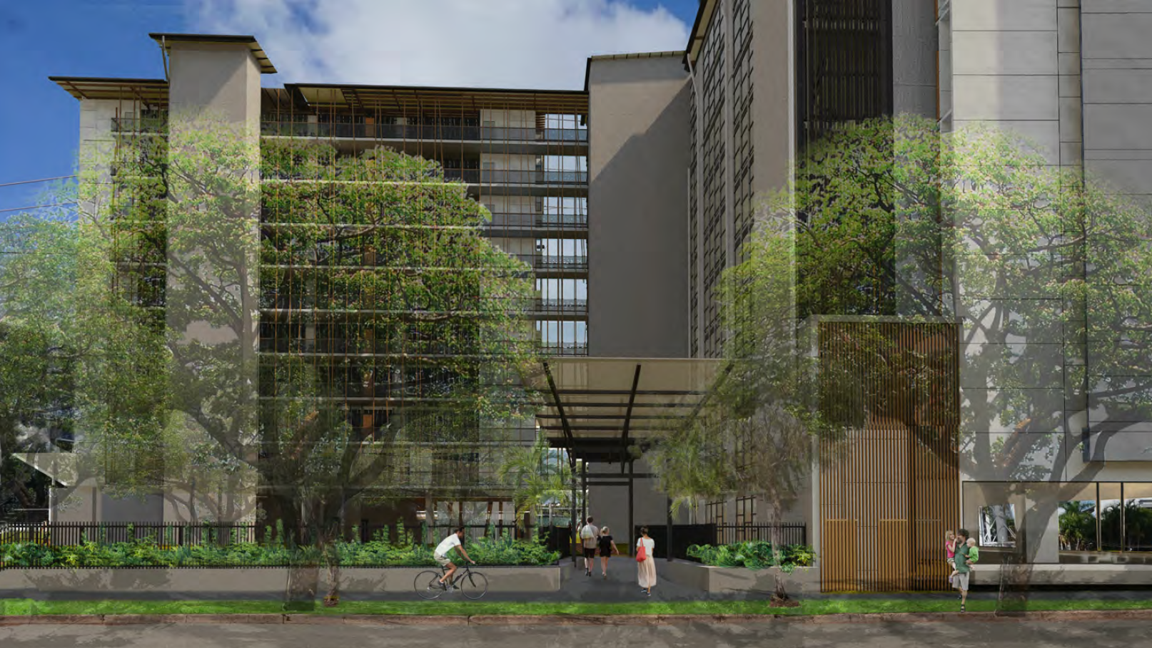
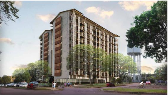
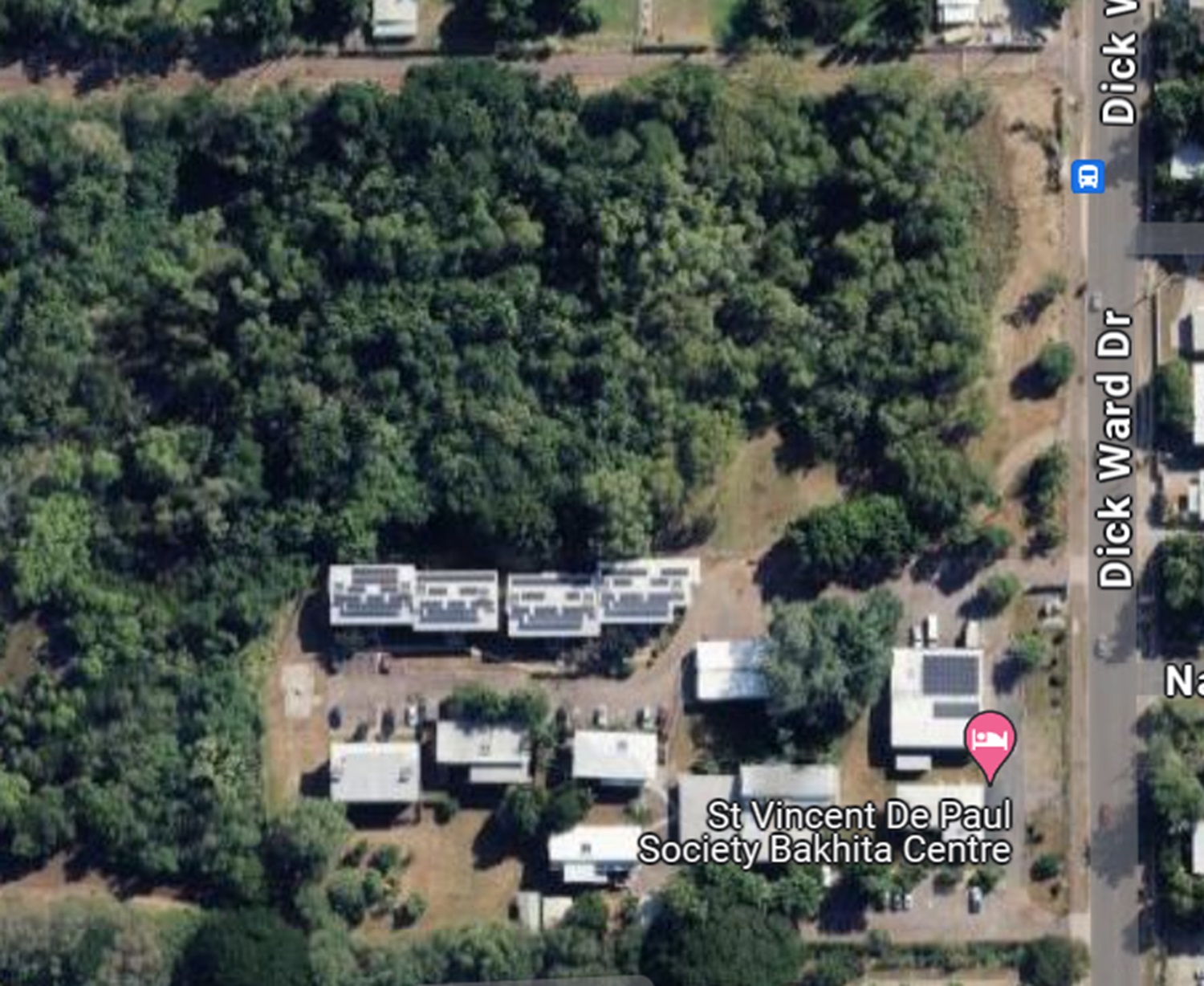
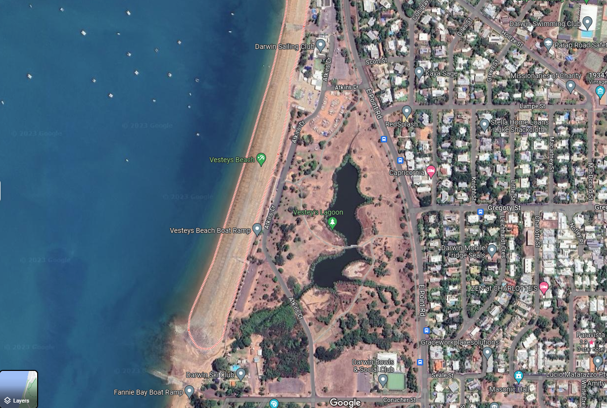
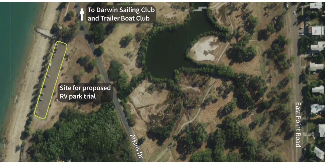
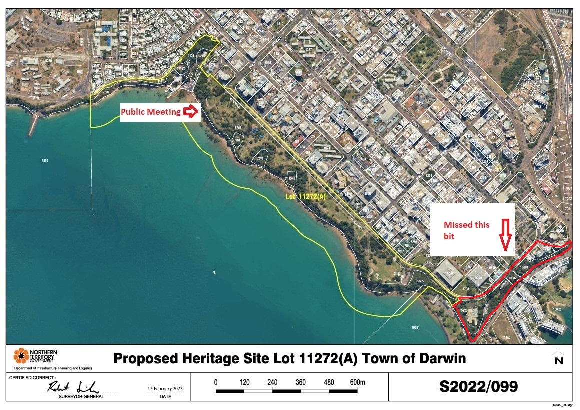
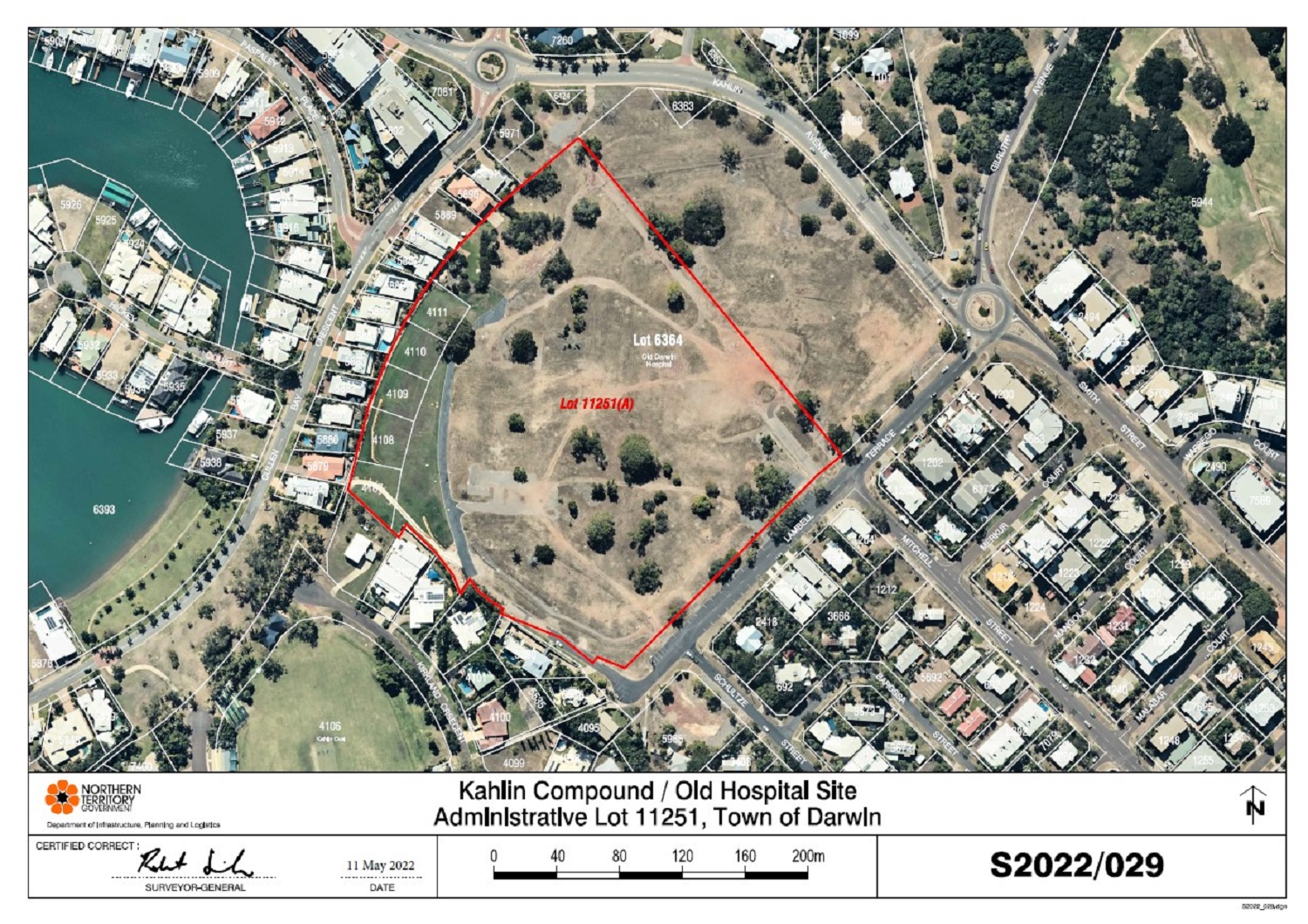
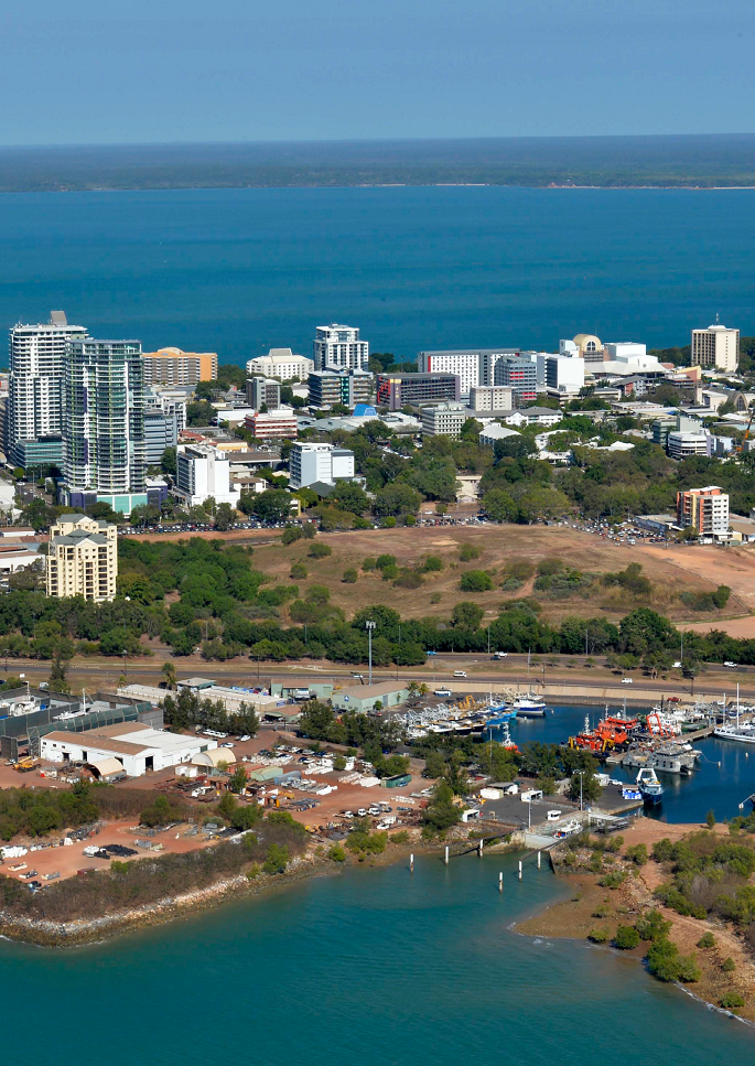
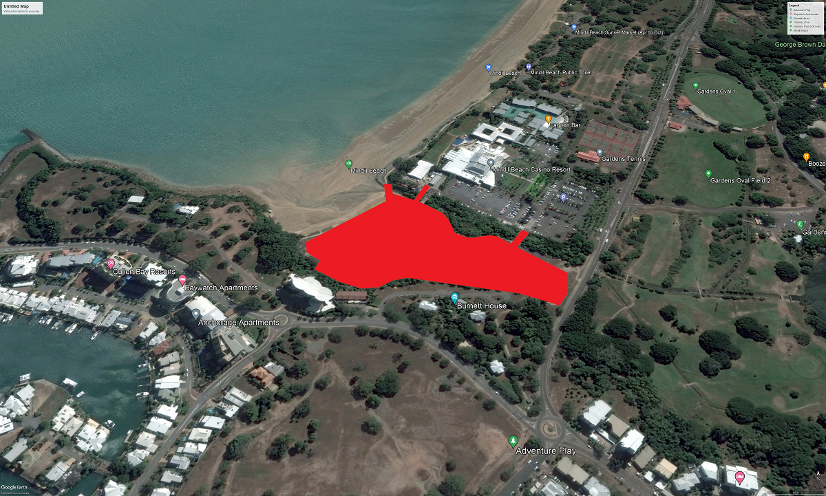
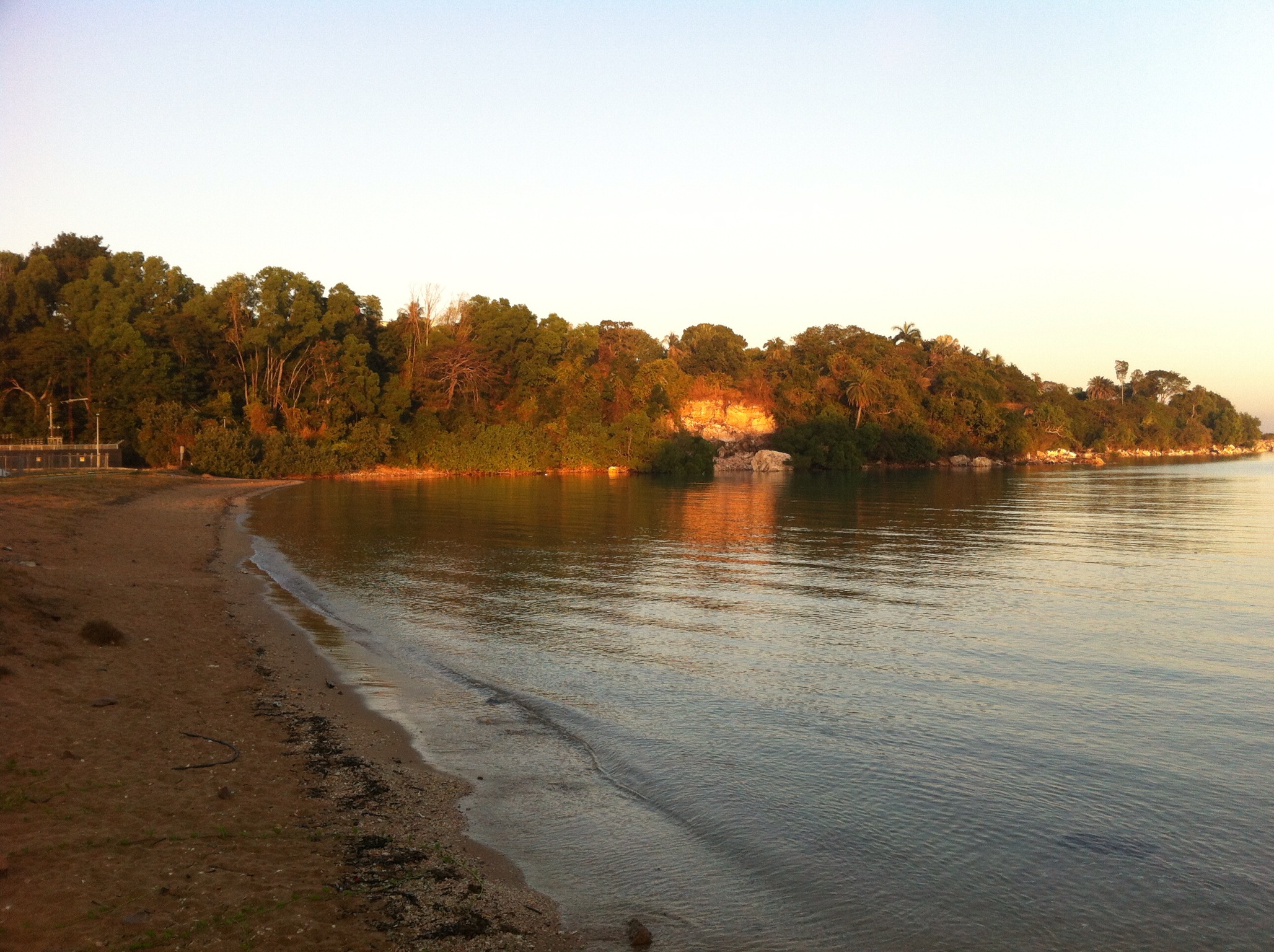
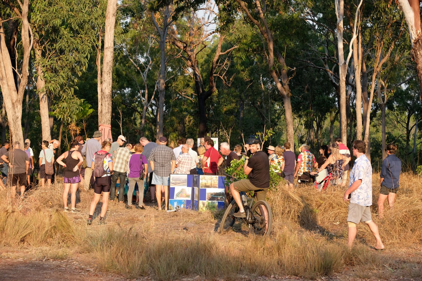
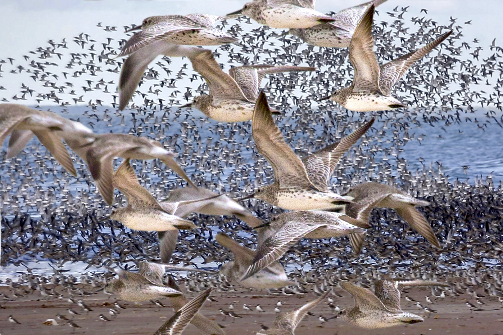
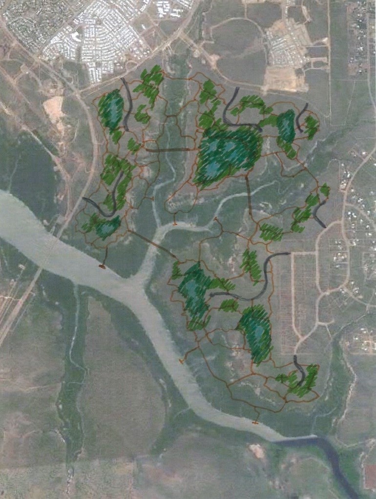


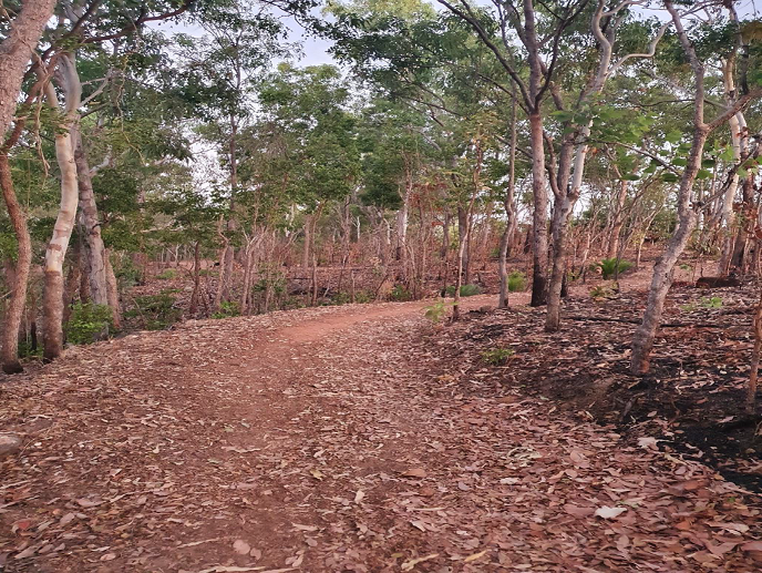


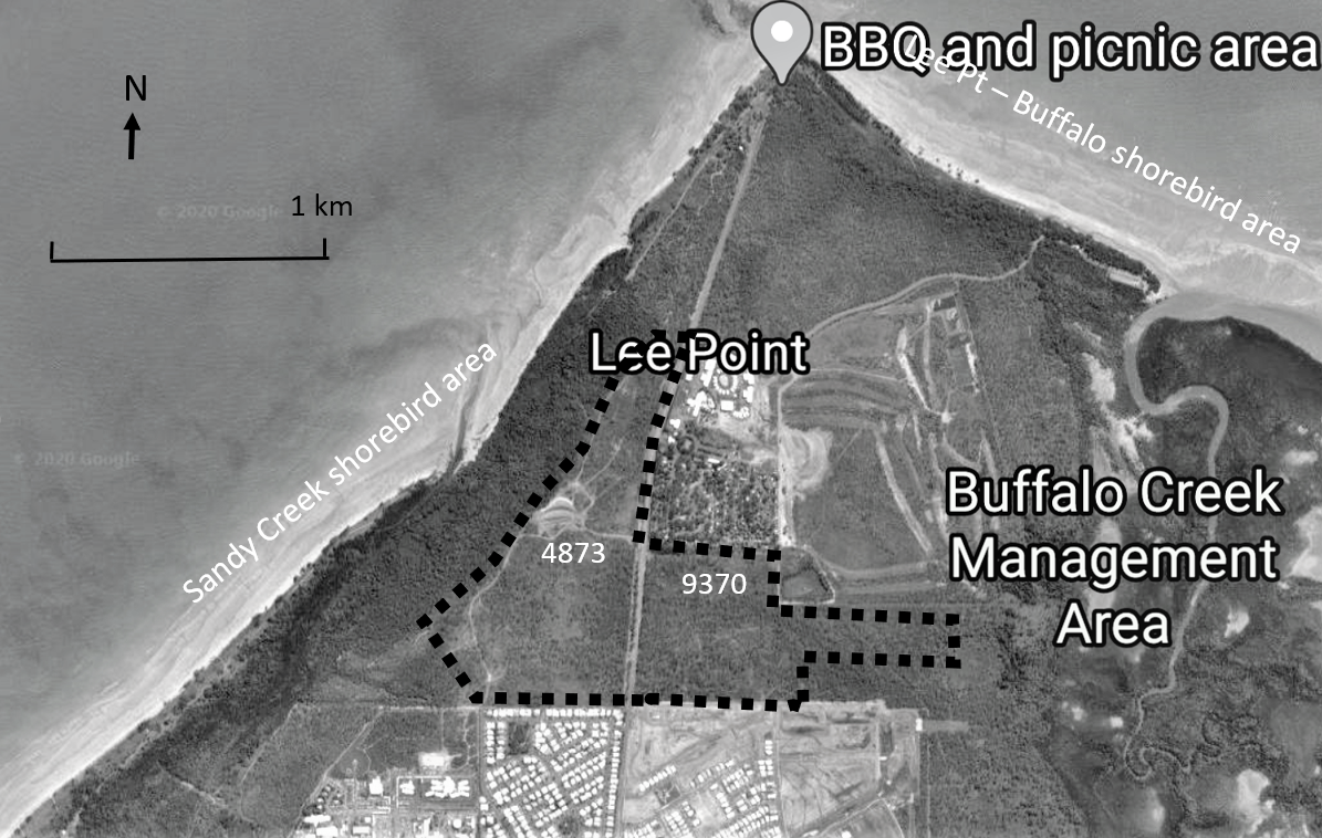
 Photo of Lee Point Road (looking north), Lot 4873 on the left.
 Black Footed Tree Rat (Wikipedia)
 Saturday 14th December 2019