At time of writing we are getting close to the hearing for PA2025/0441
Bagot Road Masterplan variation and DA Stage 1
Below are documents that have been made available.
Some random comments:
I would point out that the quality of the application and subsequent comments are of a less than convincing manner.
The use of a master plan that was developed under previous acts and schemes continues what Plan considers to “fail the pub test”, much has changed since the original master plan and a clean start would be an obvious choice.
It could also be considered an unfair playing field given the communities lack of resources.
If a definition of this sentence be provided perhaps? There are many other examples.
” A Master Plan has been previously approved the varied Master Plan as detailed above delivers the required landscape buffer and increases the size of this landscaped buffer open space. It can be deduced that amenity would be further preserved through this variation.”
I would ask who actually believes we need another commercial zone with petrol station? At what point does the justification show that particular attribute of the proposal is a good thing?
From the applicant: “Whilst land surface temperatures may be a relevant contextual feature of the locality there is no specific control relative to the matter nor measurable outcome or object within the scheme required to be met.” This would infer that we will get what ever they want to do. At this stage of the City of Darwin’s maturity do we have no protections from the construction of these heat sinks?
This sentence “Through this landscaping on site may be more robust.” Is that a statement we can take to the bank, or rather to the city of the future? The lease holder cannot point to any commercial facility that they have endowed on the city and show successful heat mitigation.
The lack of clarity over what is happening in the flood zone is frightening, a commitment to doing something in the future is not convincing in any manner. I am not sure that I would be able to prepare a document in my workplace that throughout refers to Attachment xxx. Why are they allowed to be this lax in this most critical of stages?
The City of Darwin points out they don’t have enough information to assess. The applicant says that have done multiple briefings, who are we to believe?
The proponent states “Our client also provided media briefings to media outlets for wider community awareness on the proposed development and application. This was utilised in local newspapers and other media.”
That is a stretch of imagination, when approached the local member Lauri Zeo advises she had no information about the proposal. Plan are fully justified in calling out any claim to community consultation. There is no outreach documented or noticed.
The argument the landowner thinks the project is a good idea does not address what the impact of the project on the subject land and surrounds.
Again “Our client has also sought to broadly engage with the community through media releases over the intent to develop and drawn attention to the proposal through the local paper and other media.”
We can provide any number of residents who will attest to the fallacy of this statement.
Where is this based? “Creation of new employment generating land uses both during construction and more importantly, on an ongoing basis once the development is complete and operational. This includes youth employment opportunities with retail developments employing a large number of younger staff.” Is there a basis for this?
ADG kick a goal here: “ADG also notes from the 9 December 2025 briefing session that the proponent is likely to further subdivide these lots in the future. This reinforces the importance of appropriately documenting the above development considerations within the lot and staging plans, so they are addressed comprehensively and not in a fragmented, piecemeal fashion.”
Plan concurs. “These objections to development of the site, given the absence of NT Planning controls over the airport land, may be considered by some to be commercially motivated”, is that the pot calling the kettle black?
This is the applicant describing their own documents: “In respect to the solar farm aspect this is not a use sought for approval its notation on the master plan may be considered presumptuous and misleading.”
There is then a section on noise, Plan would ask who came first? People move and then complain, perhaps maintaining buffer zones was a good idea? Earlier we had improved pedestrian traffic and landscape use and now we have “Outdoor exposure is limited, to pathways and carparking resulting in infrequent use and over limited periods.” Did anyone tell the shoppers and business owners that?
Back onto water: “Importantly development of the site will not result in real property damage up or downstream and will be demonstrated with each stage of development at the relevant time.” Is that “trust me?”
At this point there is duplication of objections and answers, again pointing to a lack of concern for the audience of the document. If the applicant cannot create a concise document what hope do we have on the development itself? Heavy reliance on cut and paste is not a good plan for mutual understanding.
To other responses, this stands out:
“No supermarket based centre exists between the City and Nightcliff. This development will service this void in the catchment and is also convenient for tourists/travellers.” There are plenty of locations in the NT without supermarkets. Where is the justifiable statistics?. J
This statement indicates a whole new way of constructing buildings has been discovered by the applicant: “The proposal does not seek to excavate the site and mobilise contaminant material and or groundwater contaminants.”
I would like to hear from any home owner in Ludmilla agree to this: “We also note the downstream owners consent to the application and the property interface with the ocean/Darwin Harbour. The tidal influence on the allotment is substantive.”
Plan notes that has yet to carried out effectively in any development for many years: “The site does salvage protected plants cycad and other non protected native species for reuse”
Proponent Responses to Public Submissions PA2025/0441
Bagot Road Masterplan Variation and DA Stage 1
PLan raises the following concerns about the proponent’s responses to community submissions.
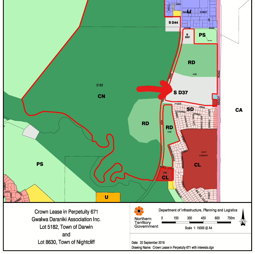
Land Use Intensity and What Was Contemplated Under the Approved Master Plan and SD37
The proponent repeatedly asserts that the proposal is consistent with what was contemplated under the 2014 approved Master Plan and SD37 provisions, that the site is appropriately zoned, and that development remains consistent with SD37 controls, including retention of substantial open space.
The weakness in the response is that it relies on assertion rather than demonstration.
There is no clear side by side comparison showing what the 2014 Master Plan actually approved, and what has changed in the amended Masterplan, including the intended land use mix, the scale and intensity of retail activity, the amount of built floor area, and the site’s intended role in the local retail network.
If the current proposal introduces an intensive retail configuration anchored around supermarket style use, a 24 hour service station, and a very large surface car park of about 510 spaces, rather than the industrial and large format retail context previously understood, the response should identify precisely where that intensity was contemplated in the approved 2014 Master Plan.
The claim that the varied Master Plan decreases scale and intensity because it increases landscaped open space is not accompanied by a measurable comparison of built floor area, site coverage, traffic generation or operational intensity between the 2014 approval and the current proposal. An increase in landscaped area does not automatically equate to a reduction in scale and intensity if commercial activity, trading hours, car parking supply and traffic generation increase.
Repeated reliance on the statement that the use is permitted or not prohibited under SD37 does not answer the separate question of whether the amended configuration represents a material change in character or intensity relative to what was previously endorsed.
Retail Network Claims and Economic Impact
The proponent states that the site forms part of the strategic retail network, that an economic impact assessment is not required, and asserts that there is a supermarket void between the City and Nightcliff.
The response does not identify the strategic planning document relied upon or reference specific planning passages. Without evidence, the claim reads as benefit framing rather than planning assessment.
The response that need has been determined through the approval for the site substitutes historical approval status for contemporary economic analysis. Planning approval does not remove the requirement to assess whether the specific retail form now proposed is justified within the current retail hierarchy.
Claimed Public Benefits
The proponent lists a series of asserted public benefits including activation of SD37, improved aesthetics, expanded retail choice, price competition, employment generation, road upgrades, pedestrian safety, landscape buffers, economic independence for traditional owners, and remediation of contamination.
The response does not show how these claimed benefits are evidenced, measured or conditioned, nor does it identify trade offs or impacts created by the same development footprint, trading intensity, servicing demand, car parking dominance, or staging structure.
The statement that the proposal delivers public interest outcomes seems to conflate private commercial benefit with demonstrated community planning benefit. The response does not show how each claimed benefit has been tested against measurable planning criteria.
Infrastructure Funding, Black Spot Intersections and Delivery Responsibility
The proponent acknowledges that the Fitzer Drive intersections are recognised black spots and states that the development will undertake road upgrades, with other works to be delivered by government agencies and the developer contributing.
The response does not state what the developer contribution is, how it is calculated, or what works it applies to. Without that detail, it remains unclear how delivery responsibility is allocated between the proponent and government.
The statement that the varied Master Plan does not increase traffic volumes because the zoning already contemplated development does not engage with whether the amended retail configuration changes peak demand patterns, turning movements or service vehicle intensity relative to prior assumptions.
Residential Amenity and the Framing of Ludmilla
The proponent argues that increased activity, lighting and noise are contemplated under the approved Master Plan and that existing conditions in Ludmilla include aircraft noise, traffic and degraded land.
The response suggests that existing unpleasant conditions in Ludmilla diminish the weight to be given to additional impacts.
This framing does not engage with the statutory obligation to assess the amenity impacts of the specific proposal. The presence of aircraft noise or existing traffic does not reduce the requirement to assess incremental impact from a supermarket anchored retail centre and 24 hour service station.
Amenity assessment requires consideration of cumulative effect. The response does not provide quantified comparison of noise levels, lighting spill, hours of operation, servicing frequency or traffic increase attributable to the amended layout.
The proponent claims that because the varied Master Plan increases the landscaped buffer, it can be deduced that amenity will be preserved. That is not demonstrated, because buffer size alone does not quantify actual amenity impacts from trading hours, lighting, noise and traffic activity.
Flight Path and Aviation Noise
The proponent relies on ANEF contours and states that no buildings are within the ANEF35 contour.
This does not address cumulative acoustic impact arising from extended retail trading, vehicle movements, plant operation and service station activity in combination with aviation noise.
Flooding and Storm Surge
The proponent relies on filling above outdated NT storm surge levels which are based on 2007 climate science, prior reporting, draft earthworks and drainage plans, and conditions precedent.
When modelling excludes sea level rise or increased rainfall intensity, the response does not engage with that limitation.
Reliance on filling to historical storm surge benchmarks based on earlier climate assumptions does not demonstrate that contemporary climate projections have been incorporated.
Conditions precedent are not a substitute for demonstrating on exhibited material that flood risk is not redistributed across the site or transferred to adjoining land or public roads.
The proponent says detailed earthworks and civil plans will be done after approval to achieve a known outcome. The risk is that, unless the approval locks in that outcome, post approval design can still change flood behaviour, finished levels, drainage paths, fill volumes and downstream impacts, without further public scrutiny.
The consent authority must be satisfied that flood and surge risk are not worsened. The response does not clearly demonstrate how that satisfaction is achieved using finalised modelling tied to the amended configuration.
Stormwater Discharge and Downstream Consent
The proponent notes downstream consent from GDA and states that discharge ultimately flows to the ocean.
Downstream landowner consent does not replace the technical requirement to demonstrate that peak flow, velocity and depth are not increased in ways that affect public infrastructure or neighbouring land. Consent is not equivalent to hydraulic verification.
Contamination and PFAS
The proponent confirms that the Remedial Action Plan is draft and being finalised and asserts that the RAP process sits outside the Planning Act and DA process.
Even if remediation is regulated under separate legislation, the planning decision must determine whether the land is suitable for the proposed use.
The response does not demonstrate how contamination risk is fully resolved within the planning assessment rather than deferred to post approval technical processes.
Approving a Masterplan variation and Stage 1 retail development prior to exhibition of final remediation methodology raises sequencing concerns.
Darwin has recognised PFAS contamination as a significant land use issue. The response does not engage with the implications of introducing high turnover retail and fuel related activity onto land acknowledged as contaminated without finalised remediation detail.
Staging, Exhibition and Cumulative Impacts
The proponent relies on the existence of SD37 and the approved Master Plan footprint and states that Stage 1 lies within Area A of the 2014 Masterplan.
The response does not demonstrate that cumulative impact assessment has been updated to reflect the amended staging structure.
Rolling approvals risk arises where master plan variations and staged development applications incrementally alter the development form without holistic reassessment against contemporary standards. The response does not substantively engage with this concern.
The proponent also states that the Masterplan variation and Stage 1 DA were made and exhibited in accordance with the Planning Act. Procedural compliance with exhibition requirements does not resolve whether the material exhibited was complete, finalised and sufficient to allow full assessment of cumulative flood, contamination, traffic and infrastructure impacts arising from the amended configuration.
Degradation of the Land
The proponent characterises the Ludmilla bush block as degraded, contaminated, illegally dumped upon and burnt.
The degraded condition reflects long term management and maintenance decisions.
Degradation is not evidence that the land lacks ecological, cultural or planning value. It is evidence of neglect.
Planning decisions should not treat neglect as justification for conversion to intensive commercial use.
Open Space and the Purpose of the Lease
The proponent states several times that the site is not public open space and is approved for commercial development.
The historical intention of the lease was to preserve Larrakia access to coastal land and maintain connection to place through a conservation zone.
Zoning status does not extinguish the cultural and conservation objectives associated with the lease history.
Heritage and Cultural Considerations
The proponent relies on GDA consent, historic studies and AAPA clearance.
The response treats consent of the leaseholder as determinative.
Where heritage significance is contested and where historical material identifies ceremonial and cultural associations in the broader landscape, reliance solely on consent letters does not substitute for transparent cultural assessment tied to the amended layout.
The response does not clearly demonstrate how the varied Master Plan has been assessed against cultural heritage provisions requiring that development not impact the significance of heritage places or objects.
Planning Scheme and Transitional Assessment
The proponent asserts that assessment occurs under the 2007 scheme and that no assessment under the 2020 scheme is required.
Even where the earlier scheme formally applies to SD37, contemporary flood, climate, contamination and amenity standards remain relevant considerations.
Reliance on historical approval status does not demonstrate that the amended proposal satisfies current environmental risk expectations.
Conclusion
Across the responses, a consistent pattern emerges.
Assertions of consistency are not supported by comparative schedules or quantified analysis.
Claims of reduced scale and intensity are not accompanied by measurable comparison of floor area, traffic generation or operational demand.
Public benefits are listed without quantified demonstration.
Infrastructure upgrades are referenced without defined funding, delivery or trigger mechanisms.
Flood, surge and contamination risks are addressed through reliance on draft material and conditions precedent rather than final exhibited documentation.
Amenity impacts are framed as already contemplated rather than specifically assessed against the amended configuration.
The responses do not clearly demonstrate that the amended Masterplan variation and Stage 1 proposal resolve the substantive planning, risk and cumulative impact concerns raised in the public submissions.
Nicholas Kirlew
Convenor, PLan
nick@planinc.org.au