Tudawali Park Meeting – 27 September
PLAN convened a public meeting at Tudawali Park on 27/09 after Ostermann residents raised their alarm and confusion about:
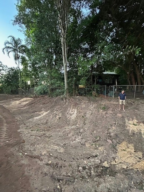
– a massive spoon drain built behind their homes,
– hectares of bush cleared on the Seth Chin block.
Ludmilla residents also wanted answers about a new fence erected around the MacDonald block and extending to Totem Road.
Residents wanted to know whether these were isolated works, or part of the staged framework in the Kulaluk–Minmarama Land Assessment Report (Byrne Consultants, August 2023).
Residents expressed their fear that the purpose of Stage 1 flood mitigation infrastructure is not simply drainage management, but to enable future residential development in primary storm surge zones.
Five senior Planning officials attended but said they were “only in a position to discuss” the stormwater mitigation infrastructure.
When Ludmilla residents asked about the fence that had been erected around the MacDonald’s block extending to Totem Road, officials said they knew nothing about the proposed development.
When questioned about how the stormwater infrastructure fit into the 11 development areas and stages outlined in the Kulaluk–Minmarama Land Assessment Report, the Acting CEO of DIPL responded that the report was produced two years ago by another, now defunct department, and promised to “seek an update on the status of that report.”
When questioned further about the Kulaluk–Minmarama Land Assessment Report (Byrne Consultants, August 2023), the Acting CEO of DIPL minimised its scope by only acknowledging the first two objectives:
– preliminary planning and assessment for enabling infrastructure for the Kulaluk and Minmarama town camps,
– assessing commercial viability and returns for the Gwalwa Daraniki Association.
She did not mention the other objectives in the report, namely:
– Identifying 11 potential development areas and stages
– Outlining constraints, infrastructure requirements, and indicative costs, and
– Aligning this staged development with the Darwin Mid Suburbs Area Plan.
What the Report actually does
It puts the Kulaluk and Minmarama Aboriginal lease areas within one staged planning framework with private sub-leased parcels along Dick Ward Drive — such as the McDonald’s block, and the Seth Chin block.
The report notes that several of the 11 identified areas fall within primary storm-surge zones. This means any potential development — including possible residential use — would occur on land at high flood and cyclone risk. It identifies the enabling works required — drainage, services, clearing, and filling to prepare these areas for potential development.
What raising land means
The report uses the term “fill to achieve flood immunity.” In practice, this means importing large volumes of soil to lift low-lying land to an artificial platform so it can be considered “development ready.” This requires expensive public works — drains, culverts, and stormwater systems.
Natural detention basin
The report itself acknowledges that parts of the Kulaluk–Minmarama lands act as a natural detention basin. In plain terms, the low-lying land slows down and holds wet-season stormwater before it flows into Ludmilla Creek. This helps prevent flooding in nearby suburbs. If the land is filled or developed, that role disappears and the extra water will be forced onto other areas.
PLan’s critique of the report
PLan noted that the report blurs the boundary between Aboriginal leasehold and privately sub-leased land, making it less clear who the development proponent is for each block.
– Piecemeal staging: advancing “Stage 1” works like the spoon drain while deferring others makes it impossible to assess cumulative impacts.
Without a whole-of-area lens, there can be no credible:
– environmental impact assessment,
– flood and storm-surge modelling,
– traffic and access planning, or
– integrated heritage and public land review.
Proposals from the meeting
Nick, PLan convenor, suggested forming a multi-stakeholder committee to meet directly with all proponents of development, ensuring transparency and community consultation.
Julie Frazer emphasised the need for transparency and better communication with residents.
References
Kulaluk and Minmarama Land Assessment Report
Prepared by Byrne Consultants for the Department of Territory Families, Housing and Communities, 10 August 2023.
Available at: https://dhlgcd.nt.gov.au/media/documents/housing2/town-camps/kulaluk-minmarama-land-assessment-report.pdf
• Report objectives: Section 1 – Executive Summary; and Section 3.2 – Project Objective.
• Identification of eleven potential development areas: Section 2 – Project Summary; and Section 4 – Proposed Development Areas.
• Constraints, infrastructure requirements and indicative costs: Section 2.3 – Key Constraints to Development; and Section 16 – Indicative Infrastructure Cost.
• Relationship to the Darwin Mid Suburbs Area Plan: Section 4.1 – Darwin Mid Suburbs Area Plan; and Section 5 – Planning Considerations.
• Storm-surge exposure, fill requirements and flood-immunity standards: Section 2.4.7 – Flooding and Storm Surge; Section 12 – Flooding and Storm Surge; and Section 15 – Engineered Solutions.
• Natural detention-basin and flood-retention function of the Kulaluk–Minmarama lands: Section 5 – Planning Considerations; and Section 12.3 – Stormwater Drainage (primary).