A Staged Development Framework?
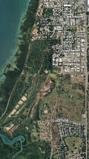
The Kulaluk–Minmarama Land Assessment Report (Byrne Consultants, August 2023) identifies 11 staged development areas within the Kulaluk (Lot 5182) and Minmarama (Lot 5183) Aboriginal lease lands.
Bundling and Staging
The report maps commercial sub-leases together with Aboriginal lease areas in its development stages, treating them within a single planning and infrastructure framework. This raises a concern because it combines privately managed commercial land with Aboriginal lease land within a single development framework, risking obscuring the distinct statutory processes that apply to each.
Enabling Works ?
The Byrne report proposes “enabling” or preparatory stormwater works and earthworks to prepare low-lying areas for development, including possible residential development. The report states that this staged development framework aligns with the Darwin Mid Suburbs Area Plan.
100-year Primary Storm Surge Area
The report shows that large areas of the Kulaluk–Minmarama lands fall within the 100-year Primary Storm Surge Area (PSSA) and also acknowledges that the Land Subject to Storm Surge (LSSS) overlay applies. This means the land is mapped as being at risk of storm surge, and any development there must comply with the special storm-surge rules in the NT Planning Scheme. Under Clause 3.7 (LSSS), residential development should be avoided in both the PSSA and the Secondary Storm Surge Area (SSSA).
Assessment Against Clause 3.7 – Primary Storm Surge Area
Proceeding with enabling works to support possible future residential development in the PSSA appears inconsistent with the NT Planning Scheme 2020 unless it can already be demonstrated that storm-surge and flood risk will not increase and consent for the development has been granted (Clause 3.7 – Primary Storm Surge Area).
Assessment against Clause 3.6 Flooding Overlay
Parts of the area are also subject to the Land Subject to Flooding Overlay. Under Clause 3.6(2) of the NT Planning Scheme 2020, development may be permitted where the consent authority is satisfied that safe access and egress for people and vehicles is available during flood events — egress means the ability to get out safely during a flood event — and that the proposed development will not increase flood risk to any other land, that is, flood risks are not transferred to neighbouring land.
Simply filling land to achieve “flood immunity” as outlined in the report is not enough. The consent authority must be satisfied the works will not worsen downstream flooding — and if only a small stage of the total works is assessed in isolation, this cumulative impact cannot be properly tested.
Enabling Works Are Still Development
The Byrne report administratively treats the early drainage, fill, and earthworks as “enabling works,” as if they are just preparation and not real development. But the Planning Scheme requires overlays to be considered even at this stage. The flooding (Clause 3.6) and storm-surge (Clause 3.7) overlays still apply, and the rules cannot be avoided by administratively categorising these works “enabling” or “infrastructure.”
Public Notice (Planning Act ss 47–49)
The Planning Act requires development applications to be publicly exhibited, with submissions considered. Splitting one coordinated project into a series of minor packages appears to undermine this process and reduce meaningful public input especially when “enabling“ works may not require a planning application to be submitted and thus trigger Public notification.
Staged Approvals (Planning Act s 56)
While the Act allows development to be approved in stages, each stage must still meet the Planning Scheme’s requirements. A stage cannot be approved if it leads to outcomes that are inconsistent with the scheme, such as increasing flood or storm-surge.
Next Steps
PLAN therefore requests that the 11 proposed stages in the Kulaluk–Minmarama Land Assessment Report be considered together as one coordinated development, subject to a full cumulative assessment. Plan requests this assessment includes:
- independent flood and storm-surge modelling,
- environmental impact analysis,
- traffic and access planning,
- an integrated review of heritage and public-land values.
Proceeding in stages without such comprehensive assessment may not give proper effect to the NT Planning Act 1999 and the NT Planning Scheme 2020.
PLAN respectfully asks that DIPL and the DCA clarify in writing how these assessment requirements will be applied before any further enabling works or approvals proceed.
References
A. Primary Source Document
[0] Byrne Consultants (2023). Kulaluk–Minmarama Land Assessment Report. Department of Territory Families, Housing and Communities, 10 August 2023.
Available at: https://dhlgcd.nt.gov.au/media/documents/housing2/town-camps/kulaluk-minmarama-land-assessment-report.PDF
B. Byrne Report Citations
[1] Report objectives – pp. 11–12; 35 (Project Overview 2.1; Project Objective 3.2).
[2] Eleven development areas and bundling – pp. 12–14 (Section 2.2; Figure 2.1 on p. 13) and pp. 22–33 (Tables 2.1–2.11 summarising the 11 development areas).
[3] Constraints, infrastructure requirements, indicative costs – p. 14 (Key Constraints) and pp. 114–116 (Section 16: Indicative Infrastructure Costs, including 16.2).
[4] Link to Darwin Mid Suburbs Area Plan – p. 50 (Planning Considerations referencing DMSAP).
[5] Storm surge, fill, and flood immunity – pp. 18–19 (Project Summary 2.4.7 Flooding and Storm Surge); pp. 77–79 (Sections 12.2–12.3); p. 84 (12.6 Summary); and pp. 94–98 (Sections 15.1–15.2 Earthworks / Drainage, including minimum fill to ~6.2 m AHD [Australian Height Datum]).
[6] Natural detention basin and flood function – pp. 18–19 (Project Summary 2.4.7) and p. 78 (Section 12.3 Stormwater Drainage, detention requirement).
C. Legislation and Planning Scheme References
[7] Planning Act 1999 (Northern Territory) – ss 47–49 (public notice), s 51(1) (matters for consideration), s 56 (staged approvals).
Available at: https://legislation.nt.gov.au/en/Legislation/PLANNING-ACT-1999
[8] Northern Territory Planning Scheme 2020 – Clause 3.6 (Land Subject to Flooding Overlay), Clause 3.7 (Land Subject to Storm Surge Overlay).
Available at: https://nt.gov.au/property/land-planning-and-development/our-planning-system/nt-planning-scheme