Ludmilla Creek: Darwin’s Last Living Creek System
Most of Darwin’s mid-suburb waterways have been channelised and degraded into stormwater drains, but Ludmilla Creek is different — it is still a living tidal system. Mangroves line its banks, fish and birdlife depend on it, and people still fish and crab here. Ludmilla creek is last remaining natural creek system in this part of Darwin.
Wildlife Corridor and Habitat Mosaic
The Kulaluk–Minmarama lands form part of a continuous corridor linking Ludmilla Creek, coastal mangroves, and remaining woodland and open space in nearby suburbs. This corridor supports movement of birds and small fauna between coastal and inland habitats and is recognised in the Greening Darwin Strategy (2021) as part of Darwin’s green spine.
Diverse Ecosystem
The Kulaluk–Minmarama lands are unusual within Darwin because they hold several distinct ecosystems side by side — mangroves along the coast and creek edges, seasonal wetlands in the low-lying areas, and eucalypt woodlands on higher ground. This diversity provides food and shelter for a wide range of species and strengthens the role of the lands as a continuous “green spine” through the mid-suburbs. Clearing or fragmenting this mosaic would mean losing not just canopy cover but whole habitat types that are now rare in urban Darwin.
Canopy Loss, Clearing, and Climate Resilience
Available data indicate that Darwin is losing shade and biodiversity at a significant rate. The CSIRO Darwin Living Lab documented an estimated 33 percent decline in canopy cover between 2016 and 2021. This equates to approximately 1,300 hectares of tree canopy lost across the greater Darwin area. Within the City of Darwin local government area, the loss was estimated at around 152 hectares. These figures highlight the scale of canopy reduction and its implications for urban cooling, biodiversity, and climate resilience. The Greening Darwin Research Collaboration (2024) calculated that Darwin must plant around 36,000 trees by 2030 just to maintain current canopy levels, and between 50,000 and 100,000 trees to restore what has been lost. If canopy decline continues, it is likely to worsen heat stress, energy costs, and liveability as temperatures continue to rise. Average temperatures in the Northern Territory have increased by about 1.5 °C since 1910. The number of very hot days (over 35 °C) in Darwin has risen from a long-term annual average of about 13 days (1981–2010) to 48 days in 2024.
Woodland Canopy Loss and Urban Heat Risk
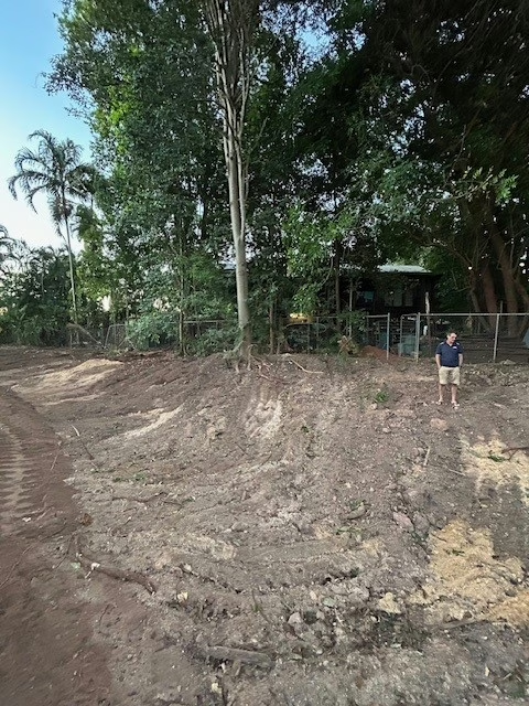
The Kulaluk–Minmarama Land Assessment Report (2023) describes “enabling works” to make the lands “development ready,” including filling to achieve “flood immunity” and building drains, culverts, and service corridors. In practice, these works would require clearing the existing woodland canopy before land can be raised and subdivided. The Seth Chin block, stage 2 of the Kulaluk–Minmarama lands assessment report framework, shows what is likely to happen: the entire block has already been completely denuded of vegetation. If the existing woodland canopy of the Kulaluk–Minmarama lands were cleared and replaced by residential subdivisions with mostly hard surfaces, urban heat is likely to increase and liveability to decline. The mid-suburbs of Darwin cannot afford to lose such a large area of woodland canopy.
Environmental Value and Regeneration
Reports indicate that parts of the Kulaluk–Minmarama lands contain legacy contamination from past dumping and fill. Even so, the land retains environmental value because it sits within a coastal ecosystem that links Ludmilla Creek, the mangroves, and nearby reserves. The area also acts as a green buffer between the creek and nearby suburbs, helping to moderate heat and dust. Maintaining vegetation cover is recognised in environmental management practice as a simple and effective way to reduce soil erosion and limit the movement of pollutants. Studies suggest that plant cover and root systems can help stabilise degraded or contaminated soils and support local habitat function. This approach aligns with accepted principles of urban environmental management, which acknowledge that disturbed land can still provide ecological benefits when protected from further disturbance.
Alignment with Policy Commitments
Local and regional strategies already mandate stronger environmental stewardship. The Greening Darwin Strategy (2021) commits to enhancing canopy, cyclone resilience, and biodiversity corridors. The Climate Emergency Strategy (2022) highlights expanding green infrastructure as essential to adapt to rising heat. The Darwin Municipal Plan 2024/25 sets “a cool, clean and green city” as a strategic priority, with budget allocations for revegetation. The lands are uniquely positioned to help deliver on these commitments.
Strategic Opportunity
Protecting and enhancing the Kulaluk–Minmarama lands is about contributing to Darwin’s climate and biodiversity goals and supporting a more liveable urban future. Development that ignores these values would undermine the city’s commitments to a cooler, greener, and more resilient Darwin.
References
- Byrne Consultants (Simon Byrne Pty Ltd T/as Byrne Consultants). (10 August 2023). Kulaluk and Minmarama Land Assessment. Revision C (Reference 22077_R001_RevC). Prepared for the Department of Territory Families, Housing and Communities. Retrieved from https://dhlgcd.nt.gov.au/media/documents/housing2/town-camps/kulaluk-minmarama-land-assessment-report.PDF
2. CSIRO Darwin Living Lab. (2023, July 13). Tree canopy cover change from 2011, 2016 and 2021. Retrieved from https://research.csiro.au/darwinlivinglab/tree-canopy-cover-change-from-2011-2016-and-2021/
3. Greening Darwin Research Collaboration. (2024, April 23). Adaptation in Action. [PDF]. Retrieved from https://www.climateemergencyaustralia.org.au/uploads/1/4/5/0/145015538/adaptation_in_action_-_greening_darwin_research_partnership.pdf
4. City of Darwin. (2021). Greening Darwin Strategy. Darwin, NT: City of Darwin. Retrieved from https://www.darwin.nt.gov.au/sites/default/files/publications/attachments/1091987_CoD_GreeningDarwinStrategy_WEB.pdf
5. City of Darwin. (2022). Climate Emergency Strategy. Darwin, NT: City of Darwin.
6. City of Darwin. (2024). Municipal Plan 2024/25: Strategic Direction ‘Cool, Clean and Green’. Darwin, NT: City of Darwin.
7. Bureau of Meteorology & CSIRO. (2022). State of the Climate 2022. Retrieved from https://www.csiro.au/en/research/environmental-impacts/climate-change/state-of-the-climate
8. Bureau of Meteorology & CSIRO. (2023). Climate Change in Australia [Report / Edition]. Retrieved from https://www.climatechangeinaustralia.gov.au/
9. Bureau of Meteorology. (n.d.). Darwin Airport – Climate Data Online. Retrieved October 2025 from https://www.bom.gov.au/climate/data/
10. Bureau of Meteorology. (n.d.). Daily maximum temperature ≥ 35 °C statistics – Darwin Airport. Retrieved October 2025 from https://www.bom.gov.au/climate/data/