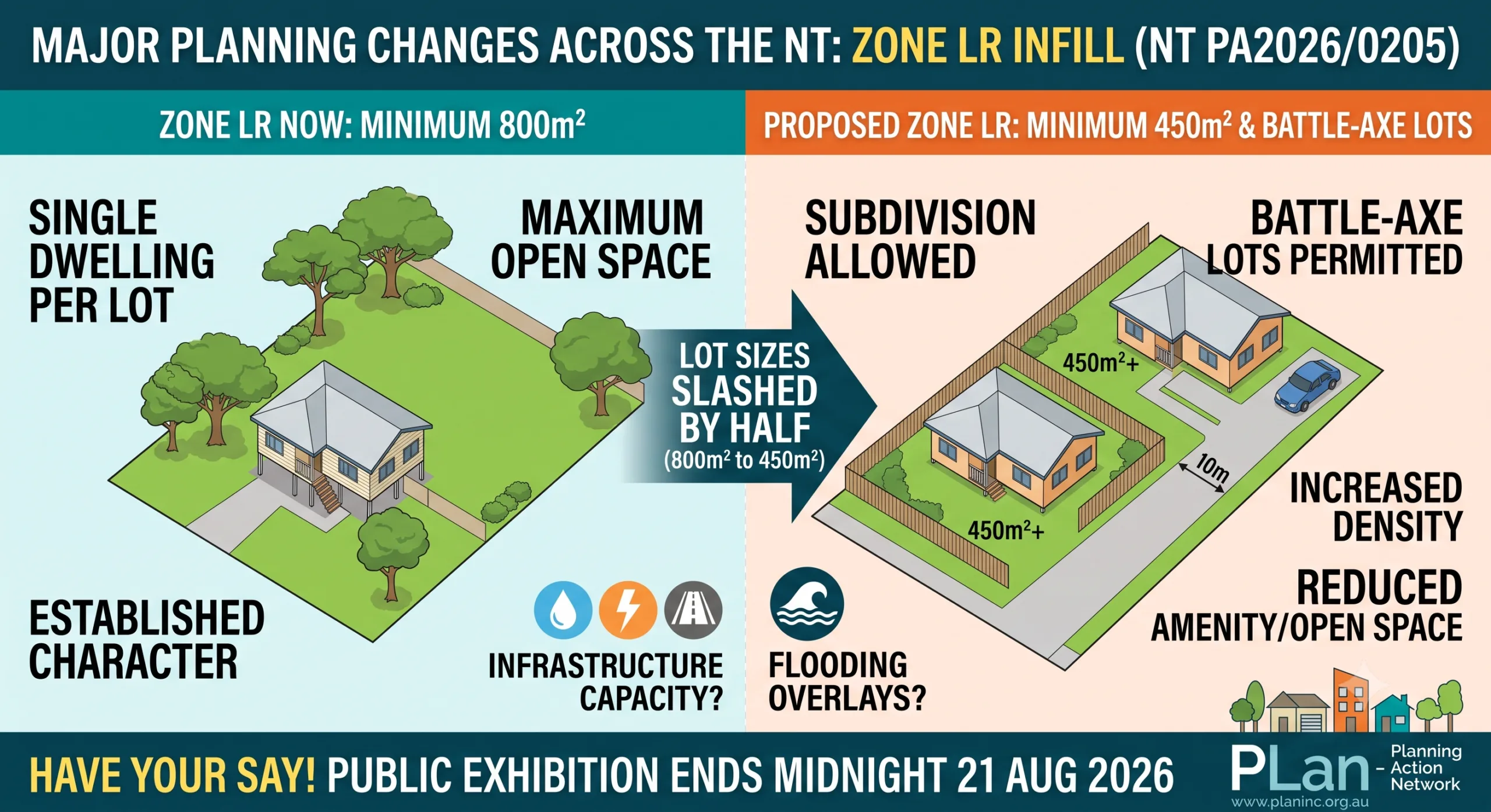
Planning Scheme Amendment PA2026/0205 is the formal exhibition process by the Northern Territory Government to introduce policy changes enabling infill development and subdivision within Zone LR (Low Density Residential) across the Territory.
In the end we sent to the following email addresses (noting confusuion from community):
planning.ntg@nt.gov.au; Das NTG das.ntg@nt.gov.au; ntpc@nt.gov.au
Here is our final submission:
Navigate to
Critical analysis of exhibited documents
Why Dual Occupancy is not good planning, especially in Darwin’s older suburbs.
Overview
Here is an overview of the key details:
1. Core Objectives
- Facilitating Infill & Subdivision: The amendment aims to increase flexibility in existing residential areas as a response to housing challenges, allowing new homes to be built on existing blocks rather than relying solely on undeveloped greenfield land.
- Reduction of Lot Sizes: It proposes reducing the minimum standard lot size for a subdivision in Zone LR from 800 m² down to 450 m².
- Expanding Housing Typologies: The changes seek to allow a broader variety of housing options within the zone, such as dwelling-groups (multiple homes on one lot) and independent secondary dwellings, while maintaining the overall low-rise character of the neighborhood.
2. Key Limitations & Protections
- Overlay Restrictions: The proposed rules state that the consent authority must not grant consent for a new lot or multiple-dwelling groups in Zone LR if the land is affected by a Land Subject to Flooding (LSF) or Land Subject to Storm Surge (LSSS) overlay.
- Infrastructure Considerations: Development capability will remain dependent on the capacity of local reticulated services and infrastructure networks, which may require upgrades in established suburbs.
- Battle-Axe Lots: New provisions define strict parameters for battle-axe subdivisions, specifying requirements such as minimum width (e.g., 10m) and maximum access length (e.g., 250m) to manage traffic and neighborhood amenity.
3. Public Exhibition Status
Submission Deadline: The amendment is currently open for public feedback, with the exhibition period closing at midnight on Friday, 21 August 2026.
How to View: Submissions and formal proposal documents are accessible via the NT Development Applications Online portal.
Section 1: Introduction and the Big Changes
PA2026/0205: What the Proposed Zone LR Changes Mean for Territory Suburbs
The Northern Territory Government is currently exhibiting a major Planning Scheme Amendment that will fundamentally reshape low-density residential areas across the Territory.
Amendment PA2020-0205 proposes to introduce sweeping changes to Zone LR (Low Density Residential) to facilitate infill development and subdivision. For decades, these neighborhoods have been characterized by single dwellings on generous lots. The new policy represents a significant shift in how suburban land can be used.
The Two Most Significant Policy Shifts:
- Lot Sizes Slashed by Nearly Half: The minimum standard lot size required for a subdivision in Zone LR is proposed to drop from 800 m² down to just 450 m².
- The Introduction of Battle-Axe Lots: The amendment introduces explicit rules to permit “battle-axe” subdivisions—where a new property is built directly behind an existing house and accessed via a long, narrow driveway strip. Under the draft rules, these access strips must be at least 10 meters wide and under 250 meters in length.
Section 2: Overlays and Infrastructure Constraints
While the amendment aims to increase housing flexibility and supply, the draft rules do include strict geographical boundaries and acknowledge serious logistical hurdles.
Environmental Protections (The Flooding Restrictions) Crucially, the amendment places an outright restriction on certain areas. The consent authority must not grant consent for the creation of a new lot, a dwelling-group, or a multiple-dwelling in Zone LR if the land is affected by key environmental overlays:
- LSF (Land Subject to Flooding)
- LSSS (Land Subject to Storm Surge)
If even a portion of a block falls within these flood or storm surge zones, subdivision under these new provisions will be prohibited to protect community safety and property.
The Infrastructure Hurdle A major factor that will determine the reality of these changes is local infrastructure capacity. In many of the Territory’s established suburbs, the reticulated services—such as sewerage, water, power, and local roads—are aging and operating with limited remaining capacity.
While the policy allows for higher density on paper, the physical ability to upgrade these underground networks will dictate where infill is actually feasible and how much it will cost.
Feedback from Power and Water Corporation (PWC) underscored the challenges associated with intensifying development in older suburbs, where much of the electricity, water and sewer infrastructure is nearing the end of its design life and is often undersized by contemporary standards. PWC noted that while networks were originally built with capacity for growth, actual usage has exceeded expectations, leaving very limited ability to accommodate additional load without significant upgrades. Examples of required upgrades include extending high- and low-voltage lines, replacing poles that lack structural capacity for larger conductors, and resolving space constraints in road reserves that can complicate new installations.
Additional constraints were identified in suburbs where sewerage infrastructure is located in easements on private land. Increased densification may limit access for maintenance, with relocation to road reserves presenting technical, spatial and cost challenges.
Section 3: How to Have Your Say (The Deadline)
Because this policy applies across the entire Northern Territory, it will impact the character, traffic, and amenity of low-density neighborhoods from Darwin to Alice Springs. Public feedback is vital to ensure community voices shape the final decision.
- Exhibition Deadline: The public comment period is open now and closes at midnight on Friday, 21 August 2026.
- How to View & Respond: You can view the full schedule of draft amendments (Appendix A) and the Explanatory Document on the NT Development Applications Online portal, where formal submissions can be lodged directly.
PLan encourages all residents to look at how these 450 m² lot limits and battle-axe provisions might affect their local streetscapes and infrastructure.
Why Dual Occupancy is not good planning, especially in Darwin’s older suburbs.
- Character: Dual occupancy and subdivision will destroy older tropical houses and leafy cool gardens replacing them with houses crowded together or attached and with minuscule gardens. The “iconic” character of these suburbs will be irreversibly destroyed and the city’s urban forest will gradually become a concrete heat sink.
- Health: Blocks of 500m² have little room outside for children and pets to play safely, or for families to socialize. In a hot tropical climate, shady outdoor space is essential for family health and well-being.
- Lifestyle: Small blocks cram people together, maximizing noise and minimizing privacy, especially with windows open in the dry season. Negative social impacts will be the result.
- Environment: Older tropical houses use natural cooling much more than is possible with densely built dwellings, which stop breezes, increase the need for air-conditioning and the use of electricity, adding to the effects of climate change.
- Infrastructure: Dual occupancy and subdivision will overload existing near-capacity services in the older suburbs which date from the 1950s / 1960s e.g. roads, electricity, sewerage, storm-water drainage, as well as overload the suburbs’ amenities e.g. schools, preschools, childcare centres.
- Investment: Residents of the older suburbs have made significant financial commitments to live here, often made greater by renovations. Their investments are at risk of being compromised by the degradation caused by dual occupancy and subdivision.
- Wildlife: Many animal species inhabit the ‘large’ blocks in the leafy older suburbs. Decimating the gardens will decimate the animal populations that we value.
- Heritage: The older suburbs are the last remaining remnants of ‘old’ Darwin. They have heritage and tourism value and should be preserved. Darwin has been ravaged by cyclones and war, it doesn’t need to be ravaged by dual occupancy and subdivision.
Why Dual Occupancy is not needed in Darwin
- The 2016 Darwin Inner and Mid Suburbs Area Plans identified locations where densification could occur to cater for the expected population growth’ over the next 50 years, without having to resort to dual occupancy and subdivision of SD blocks.
- The population of Darwin is barely growing.
- The housing vacancy rate is high.
- Developments like the Berrimah Farm project have provided a large increase in new available residential properties.
Critical analysis of exhibited documents
1. Explanatory Document – Proposed Planning Scheme Amendment: Infill Development and Subdivision in Zone LR
Overall assessment
The explanatory document clearly describes the proposed Planning Scheme amendments and how they would operate. However, it provides only limited evidence to support why the proposed changes are appropriate across all Zone LR land. Many of the document’s central propositions are presented as statements rather than being supported by analysis, modelling or quantitative evidence.
The document assumes that existing planning controls are the primary constraint on housing supply.
The document states that the current minimum lot size and restrictions on housing types constrain development, limit housing diversity and make it difficult to respond to changing household needs. However, it does not examine whether other factors, such as construction costs, financing, infrastructure constraints, developer demand or market conditions, may also be contributing to housing supply. The need for planning reform is asserted rather than demonstrated.
The justification for infill development relies on broad planning principles rather than evidence specific to the Northern Territory.
The document states that infill development makes more efficient use of serviced land and existing infrastructure, supports population growth and increases housing diversity. However, it provides no Territory-specific evidence demonstrating that these outcomes are likely to result from the proposed amendments.
Existing infrastructure is repeatedly relied upon but not assessed.
A central justification for the amendment is that it will make more efficient use of existing infrastructure. Despite this, the document contains no assessment of the capacity of roads, water, sewerage, electricity, schools, health services or community facilities to accommodate increased development. Nor does it identify which established suburbs have sufficient infrastructure capacity and which may require substantial upgrades.
The amendment applies across all Zone LR land without demonstrating that all areas are equally suitable.
The proposed amendment applies broadly across Zone LR throughout the Northern Territory, subject to flood and storm surge restrictions. The document does not explain why a Territory-wide amendment is preferred over identifying suitable locations through place-based planning or infrastructure-led planning. Local differences in infrastructure capacity, lot configuration and neighbourhood characteristics are acknowledged but not analysed.
The document assumes that increasing development opportunities will increase housing supply.
Reducing minimum lot sizes and permitting additional housing types creates opportunities for redevelopment. However, the document does not estimate how many additional dwellings are expected to result, the likely rate of redevelopment, or the extent to which landowners are expected to utilise the new provisions. The likely effectiveness of the amendment therefore cannot be assessed from the information provided.
Housing diversity and housing affordability are treated as closely related objectives.
The document links increased housing diversity with addressing housing challenges but provides no evidence that reducing minimum lot sizes or permitting additional housing types will improve housing affordability. It does not quantify expected effects on house prices, rental affordability or housing accessibility.
The document states that neighbourhood character will be maintained but provides little supporting analysis.
The document repeatedly states that the amendment will maintain the intent and character of Zone LR while allowing smaller lots and additional housing types. It does not explain how neighbourhood character has been assessed or how it is expected to change over time as redevelopment occurs. No cumulative redevelopment modelling, urban design analysis or assessment of likely neighbourhood change is presented.
Infrastructure constraints are acknowledged but largely deferred to future development assessment.
The document recognises that increased development intensity may require infrastructure upgrades and that not all sites will be suitable because of infrastructure or site constraints. However, rather than identifying where increased density is appropriate before amending the Planning Scheme, these matters are largely left to be considered during assessment of individual development applications.
The document contains limited quantitative evidence.
The explanatory document does not quantify:
the number of additional dwellings expected to result from the amendment;
expected redevelopment rates;
likely improvements in housing affordability;
infrastructure demand;
traffic generation;
impacts on community facilities;
impacts on tree canopy or urban heat.
Without this information, readers cannot independently assess whether the anticipated benefits are proportionate to the scale of the proposed reforms.
The document relies heavily on future development assessment.
A recurring theme throughout the document is that development permits will continue to be required and that applications will be assessed against the NT Planning Scheme. While this explains how individual developments will be managed, it does not address the broader strategic question of whether the proposed Territory-wide changes are supported by sufficient evidence before the Planning Scheme is amended.
Questions arising from the document
What evidence demonstrates that reducing the minimum lot size to 450 m² will materially increase housing supply?
What evidence demonstrates that the proposed reforms will improve housing affordability?
Which Zone LR suburbs have sufficient infrastructure capacity to accommodate increased density without major upgrades?
Why is a Territory-wide amendment proposed instead of identifying suitable locations through place-based planning?
How has the Government assessed the cumulative impacts of widespread redevelopment on traffic, infrastructure, tree canopy, urban heat and neighbourhood character?
What modelling demonstrates that the proposed changes will maintain the character and intent of Zone LR as redevelopment occurs?
2. Appendix A: Proposed Amendments to the NT Planning Scheme 2020
Overall assessment
This appendix contains the proposed legal amendments to the NT Planning Scheme rather than the policy justification for those amendments. It clearly sets out the drafting changes but provides little explanation of why particular standards or thresholds have been selected. As a result, many of the planning implications can only be inferred from the legal changes themselves.
The amendments significantly broaden the scope of development within Zone LR.
The proposed changes expand Zone LR beyond predominantly detached housing by making dwelling-groups and dwelling-multiple developments anticipated forms of development within the zone. This represents a substantial policy shift for low density residential areas.
The reduction in minimum lot size is a major policy change.
The proposed reduction in the minimum lot size from 800 m² to 450 m² fundamentally changes the development potential of Zone LR land. The appendix does not explain why 450 m² was selected or why the same standard is appropriate across all established suburbs.
Additional residential density is enabled through both the new standard and discretionary variation.
The amendments introduce a density standard of one dwelling per 450 m² while also allowing the consent authority to approve a further 10% increase in density. The appendix does not explain why an additional discretionary increase is necessary or what planning circumstances would justify its use.
Performance based discretion remains a central feature of the Planning Scheme.
Many provisions continue to rely on the consent authority being “satisfied” that development is appropriate, consistent with the purpose of the clause or will not adversely affect amenity or the road network. The amendments do not introduce objective criteria to guide these discretionary decisions or promote consistency between developments.
Infrastructure capacity is recognised but not objectively tested.
The amendments continue to refer to compatibility with existing or planned reticulated services and community facilities, but they do not establish measurable infrastructure capacity thresholds or specify how available capacity is to be demonstrated before increased density is approved.
The amendments rely on development controls to protect neighbourhood amenity.
Reduced setbacks, landscaping requirements, private open space, frontage widths, driveway widths and building articulation are intended to manage the effects of smaller lots. The appendix does not provide evidence that these controls are sufficient to maintain the established character and amenity of existing suburbs as redevelopment increases.
Battle axe lots become a recognised subdivision outcome.
The amendments introduce detailed standards for battle axe lots, including minimum access width and maximum access length. This represents a shift from discouraging these lot configurations to regulating them as an accepted form of subdivision within Zone LR.
Hazard overlays receive clear statutory protection.
The amendments prohibit subdivision, dwelling-groups and dwelling-multiple developments on land affected by the Land Subject to Flooding and Land Subject to Storm Surge overlays. This is one of the few provisions that establishes a clear, objective limitation on development.
Existing development principles are modified rather than replaced.
Several long standing planning principles, including residential density, setbacks, subdivision design and vehicle access, are amended to accommodate smaller lots rather than being comprehensively reviewed. The cumulative effect of these individual amendments is a substantial increase in redevelopment potential across Zone LR.
The amendments contain no mechanism for monitoring cumulative impacts.
The appendix establishes new planning rules but does not require monitoring of their cumulative effects on infrastructure, traffic, neighbourhood character, tree canopy or urban heat after implementation.
Questions arising from the appendix
Why was 450 m² selected as the new minimum lot size?
Why is a further 10% density variation considered necessary?
How will infrastructure capacity be assessed before additional density is approved?
How will the consent authority apply broad discretionary tests consistently?
How will the cumulative effects of these legal changes be monitored across established suburbs?
3. Consultation Summary Report: Infill Development and Subdivision in Zone LR
Overall assessment
The report provides a useful record of consultation feedback but offers only a limited evidentiary basis for Territory-wide planning reform. It demonstrates that participants raised numerous concerns about infrastructure, cumulative impacts and place-based planning, yet it does not explain why those concerns should not alter the proposed reforms.
The consultation provides a limited evidence base.
The consultation was conducted between 25 November and 19 December 2025, a relatively short period immediately before Christmas. It attracted 28 written submissions, 25 surveys and 108 quick poll responses. The report itself acknowledges that these responses are not statistically representative of the Northern Territory population. For planning reforms affecting every Zone LR suburb, this is a limited consultation base.
The report overstates the level of support.
The report refers to broad support for the reforms. However, the detailed results show that only four written submissions clearly supported the proposal. Fourteen supported it only subject to important conditions, seven opposed it and three expressed no clear position. The consultation demonstrates qualified support rather than a clear mandate for Territory-wide reform.
Support was consistently conditional.
Even respondents who supported increased housing diversity frequently qualified their support by calling for infrastructure planning, protection of neighbourhood character, staged implementation and further consultation. The report records these qualifications but does not examine their implications for the proposed reforms.
Infrastructure emerged as one of the dominant concerns.
Concerns about roads, sewerage, water, electricity, drainage, schools and community infrastructure appear throughout the consultation. Many respondents argued that infrastructure capacity should be demonstrated before increasing development potential. The report records these concerns but does not identify which suburbs have sufficient capacity to accommodate additional density.
Place-based planning was a recurring recommendation.
Many submissions argued that increased density should be directed to locations where infrastructure, transport and services already exist, rather than applying uniform planning changes across all Zone LR land. The consultation therefore supports a more targeted planning approach than the Territory-wide reforms that followed.
Participants repeatedly raised cumulative impacts.
Many respondents were concerned about the combined effects of incremental redevelopment on traffic, parking, neighbourhood character, tree canopy, urban heat, drainage and public infrastructure. The report records these concerns but does not consider how cumulative impacts should be assessed before broad planning reforms are introduced.
Power and Water Corporation identified significant infrastructure constraints.
Power and Water Corporation advised that many established suburbs have limited remaining infrastructure capacity, that upgrades may be substantial and costly, and that infrastructure availability may become a “first come, first served” issue. This advice raises important strategic questions about whether some areas are capable of accommodating increased density without significant public investment.
The consultation identified evidence that had not yet been produced.
Participants repeatedly requested:
infrastructure capacity studies;
place-based planning;
spatial mapping;
cumulative impact assessment;
staged implementation;
further consultation.
These requests indicate that many participants considered additional strategic work necessary before Territory-wide planning changes were made.
Housing affordability is assumed rather than demonstrated.
The consultation records support for improving housing affordability but also includes concerns that simply increasing development opportunities may not result in more affordable housing. The report does not resolve this issue or identify evidence demonstrating that the proposed reforms would materially improve affordability.
The consultation exposes competing planning objectives.
Participants supported greater housing choice while also seeking protection of neighbourhood character, tree canopy, open space, streetscape, parking, privacy and urban amenity. The report documents these competing objectives but does not explain how they can all be achieved simultaneously through smaller lots and increased redevelopment.
The report documents concerns more thoroughly than it resolves them.
One of the report’s strongest features is its detailed summary of stakeholder concerns. Its principal weakness is that it records those concerns without explaining why they do not justify a different planning approach, such as staged implementation, suburb-specific planning or completion of infrastructure studies before Territory-wide reform.
Questions arising from the report
Does this consultation provide a sufficient evidence base for Territory-wide planning reform?
Why were Territory-wide amendments preferred over the place-based planning repeatedly requested by participants?
Where are the infrastructure capacity studies called for throughout the consultation?
How will cumulative impacts be assessed across established suburbs?
What evidence demonstrates that the proposed reforms will improve housing affordability rather than simply increase development potential?
Why were the strategic studies requested during consultation not completed before proceeding with the proposed Planning Scheme amendments?
4. Discussion Paper: Infill Development and Subdivision in Zone LR
Overall assessment
The discussion paper is intended to stimulate community discussion rather than justify a final policy position. However, it presents the potential benefits of infill development in considerably more detail than the potential risks. Many of its central propositions are asserted without supporting evidence, and several important planning questions are left unexplored.
The discussion begins from the assumption that planning controls are barriers to development.
The paper introduces the review as part of the Government’s commitment to removing barriers to investment and implementing the Approvals Fast Track Taskforce recommendations. It assumes that existing planning controls are constraining development but does not examine whether other factors, such as construction costs, financing, infrastructure limitations or market conditions, are contributing to housing supply.
The case for reform relies heavily on general statements rather than Territory-specific evidence.
The paper states that infill development will improve housing choice, support diverse households, make better use of infrastructure and create more vibrant neighbourhoods. It provides little Territory-specific evidence demonstrating that these outcomes are likely to occur if the proposed changes are introduced.
Comparisons with other jurisdictions are selective.
The paper refers to planning reforms in the ACT, New South Wales and Brisbane to support the proposed changes. It does not discuss whether those jurisdictions have different infrastructure capacity, population growth, urban form or planning frameworks that may limit the usefulness of direct comparisons with the Northern Territory.
The discussion focuses on benefits but gives comparatively little attention to potential adverse impacts.
The paper lists numerous potential benefits of infill development but provides only limited discussion of possible adverse consequences, including increased traffic, parking demand, cumulative infrastructure pressures, loss of tree canopy, urban heat or neighbourhood change. This creates an imbalance between the presentation of potential benefits and potential risks.
Infrastructure is identified as important but not examined.
The paper acknowledges that infrastructure capacity is a hurdle to infill development and refers to adequate infrastructure as a prerequisite for change. However, it contains no assessment of existing infrastructure capacity, no mapping of constrained areas and no explanation of how infrastructure capacity would be evaluated before planning controls are changed.
The proposed planning controls are presented without explaining why they have been selected.
The paper introduces concepts such as a 450 m² minimum lot size, one dwelling per 450 m², battle axe lots and minimum frontage requirements. It does not explain why these particular standards have been chosen in preference to alternative standards or what evidence supports them.
Protection of neighbourhood amenity is largely presented as a matter of development controls.
The paper suggests that setbacks, height limits, landscaping, parking and private open space requirements will protect neighbourhood amenity. It does not consider whether these controls are sufficient to maintain neighbourhood character where redevelopment occurs progressively across an entire suburb.
The paper identifies approximately 8,000 potentially suitable lots but provides little further analysis.
The paper states that about 8,000 Zone LR lots larger than 900 m² are not affected by flooding or storm surge. It also acknowledges that not all of these lots will be suitable for redevelopment. However, it does not estimate how many are likely to redevelop, where they are located or what cumulative impacts widespread redevelopment could have.
Cumulative impacts are not explored.
The discussion paper focuses primarily on the design and assessment of individual redevelopment proposals. It does not examine the cumulative effects that large numbers of similar developments could have on infrastructure, traffic, schools, public services, urban heat, tree canopy or neighbourhood character across established suburbs.
The discussion paper raises questions that are not answered before reform is contemplated.
The paper acknowledges that infrastructure capacity, environmental constraints and neighbourhood amenity are important considerations. However, it does not explain how these matters will be resolved before planning controls are amended or what further investigations are required before reforms proceed.
Questions arising from the discussion paper
What evidence demonstrates that existing planning controls are the principal barrier to housing supply?
Why was a minimum lot size of 450 m² identified as the preferred option?
Which suburbs have sufficient infrastructure capacity to support increased density?
What assessment has been undertaken of the cumulative impacts of widespread redevelopment?
How were interstate planning examples assessed for their relevance to Northern Territory conditions?
What evidence demonstrates that the proposed development controls will maintain neighbourhood character as redevelopment increases?
5. Report to the Minister: Infill Development and Subdivision in Zone LR
Overall assessment
The report documents many of the concerns raised during consultation and acknowledges significant infrastructure, planning and implementation challenges. However, it provides only a limited justification for why broad amendments to the NT Planning Scheme should proceed before many of those issues have been resolved.
The report begins from the premise that planning reform should proceed.
The report was prepared in response to the Government’s request to identify opportunities to facilitate infill development and implement recommendations arising from the “Saying Yes to Business” Fast Track reforms. It examines how planning reform could be implemented rather than whether Territory-wide reform is necessary.
The report acknowledges that support for reform was conditional.
The report concludes there was broad overall support for infill development. However, it also acknowledges that much of this support was conditional and dependent upon infrastructure capacity, appropriate design controls and planning oversight being addressed. These qualifications are central to assessing whether the reforms are ready to proceed.
Infrastructure is recognised as a prerequisite but is not strategically assessed.
The report repeatedly states that infill development should occur only where adequate infrastructure exists. However, it does not identify which suburbs have sufficient infrastructure capacity or provide strategic analysis demonstrating where increased density can be accommodated.
Power and Water Corporation identifies significant infrastructure constraints.
Power and Water Corporation advises that many established suburbs have limited remaining infrastructure capacity, that significant upgrades may be required, that developers may need to fund those upgrades, and that infrastructure limitations may create a “first come, first served” outcome. These constraints raise important questions about the practical delivery of the proposed reforms.
Territory-wide reform is recommended despite repeated calls for place-based planning.
The report records repeated requests for location-specific planning, staged implementation, infrastructure mapping and alignment with Area Plans. Nevertheless, it recommends broad amendments to the NT Planning Scheme rather than identifying those locations where increased density has been demonstrated to be appropriate.
The report relies heavily on future assessment.
Many issues identified during consultation, including infrastructure capacity, design controls, lot configuration and detailed planning controls, are proposed to be addressed through future planning work or development assessment. The report therefore recommends proceeding before many of the strategic issues identified during consultation have been resolved.
The report repeatedly qualifies its recommendations.
Throughout the report, recommendations are accompanied by qualifications such as further testing, additional analysis, further consultation and consideration of local circumstances. These repeated qualifications suggest that important elements of the supporting evidence remain incomplete.
The report contains limited quantitative evidence.
The report discusses housing affordability, housing supply, infrastructure and housing diversity but provides little quantitative analysis demonstrating:
how many additional dwellings are likely to result;
the likely effect on housing affordability;
expected redevelopment rates;
infrastructure demand;
traffic generation;
impacts on schools, parks and community facilities.
Without this information it is difficult to assess whether the anticipated benefits are proportionate to the scale of the proposed reforms.
The report contains an internal tension.
The report acknowledges that infrastructure constraints, development feasibility, lot configuration and landowner appetite may substantially limit redevelopment. It also recognises that significant infrastructure upgrades may reduce the feasibility of many projects. Despite these acknowledged constraints, it still recommends broad amendments to the Planning Scheme.
Cumulative impacts are recognised but not assessed.
The report records repeated concerns about cumulative impacts on infrastructure, traffic, parking, neighbourhood amenity and community facilities. However, it does not undertake a strategic assessment of how widespread redevelopment across established suburbs may affect roads, schools, health services, sewerage, water, electricity, tree canopy or urban heat.
Strategic planning is deferred.
The report recommends amendments to the NT Planning Scheme before completing the place-based planning, infrastructure analysis and strategic investigations repeatedly identified during consultation. Many strategic questions are therefore left to later planning processes or individual development assessments rather than being resolved before the Planning Scheme is amended.
Questions arising from the report
Where is the suburb-by-suburb infrastructure capacity analysis?
Which Zone LR suburbs can accommodate increased density without major infrastructure upgrades?
What evidence demonstrates that reducing minimum lot sizes to 450 m² will materially improve housing affordability?
How will cumulative impacts across established suburbs be assessed?
Why proceed with Territory-wide amendments before completing the place-based planning, infrastructure analysis and further testing identified throughout the report?
6. Approvals Fast-Track Taskforce Supplementary Report: Saying “Yes” to Business
Overall assessment
The report is not an independent review of the planning system. It was commissioned to identify ways to reduce approval timeframes and regulatory burden on business. Its recommendations therefore begin from the policy objective of accelerating approvals rather than determining whether existing regulatory safeguards remain appropriate.
The report was prepared by a business-led taskforce.
The Taskforce consisted primarily of representatives from business, construction, property development and industry. The report does not indicate comparable representation from local government, environmental organisations, community planning groups, infrastructure providers or public interest organisations. This composition is relevant when assessing the balance of the recommendations.
The report assumes regulation is the primary barrier to economic activity.
Throughout the report, delays in approvals are attributed principally to regulation, regulatory culture and government processes. Little consideration is given to whether existing planning controls serve broader public purposes, including protecting neighbourhood amenity, infrastructure capacity, environmental values or long-term urban planning outcomes.
Economic benefits are emphasised more than public interest considerations.
The report repeatedly refers to reducing costs, increasing investment, improving business certainty and stimulating economic growth. It gives comparatively little attention to the broader objectives of the planning system, including orderly development, cumulative impacts, environmental protection, community participation and long-term liveability.
A risk-based approach is promoted without defining acceptable levels of planning risk.
The report repeatedly recommends exempting “low-risk” activities from existing regulatory requirements, public notification and planning approvals. However, it provides no objective framework for determining what constitutes low planning risk or how cumulative impacts will be considered where many individually low-risk developments occur over time.
Public participation is treated primarily as a source of delay.
Several recommendations seek to reduce or remove public notification requirements for developments regarded as low risk. The report presents public consultation largely as a regulatory burden rather than an important component of transparent planning and community participation. It does not examine the public interest implications of reducing opportunities for community input.
The report advocates expanding permitted development.
The recommendations include reviewing Merit Assessable uses, converting more development to Permitted Use, simplifying rezoning processes and exempting additional development from approval requirements. The report provides little analysis of how these changes may reduce independent scrutiny of development proposals.
Infrastructure receives comparatively limited attention.
The report recommends streamlining approvals but contains little analysis of whether existing roads, sewerage, water, drainage, schools and community infrastructure are capable of accommodating increased development. Infrastructure capacity is largely treated as an implementation issue rather than a prerequisite for planning reform. saying-yes-to-business-supplementary-report.pdf
The report does not assess cumulative impacts.
The report considers individual approval processes and regulatory efficiency but does not evaluate the cumulative effects of widespread planning reform on established suburbs. It contains no strategic assessment of impacts on traffic, urban heat, tree canopy, neighbourhood character, public infrastructure or community services.
Regulatory discretion is expanded while public oversight is reduced.
The report recommends increasing delegation, expanding discretion and reducing public notification for many approval processes. While these measures may reduce approval timeframes, the report does not consider whether they may also reduce transparency, accountability and public confidence in planning decisions. saying-yes-to-business-supplementary-report.pdf
The report assumes faster approvals are inherently beneficial.
Reducing approval timeframes is treated as a policy objective throughout the report. There is little consideration of whether longer assessment periods may sometimes be justified where proposals raise complex planning, infrastructure or environmental issues. saying-yes-to-business-supplementary-report.pdf
The report provides little evidence linking faster approvals with housing affordability.
Several later planning reforms rely on recommendations originating from this report. However, the report itself provides little evidence that reducing planning controls, increasing development flexibility or shortening approval processes will materially improve housing affordability.
Questions arising from the report
Was the Taskforce sufficiently balanced to make recommendations affecting the broader public interest?
What evidence demonstrates that planning regulation, rather than other economic factors, is the principal constraint on housing supply?
How will cumulative impacts be assessed if more development is exempt from planning approval and public notification?
What objective criteria will determine whether a development is genuinely “low risk”?
How will infrastructure capacity be assessed before planning controls are reduced?
What evidence demonstrates that reducing regulatory requirements will improve housing affordability rather than simply increase development opportunities?
Example analysis of maps
Appendix B: Town of Darwin Map
Overall assessment
The map identifies Zone LR parcels of 900 m² or greater that are outside the mapped flood and storm surge overlays and are therefore potentially capable of redevelopment under the proposed Planning Scheme Amendment. However, it is a screening map rather than a planning assessment. It identifies land that may be eligible for redevelopment but provides no analysis of whether redevelopment is appropriate.
The map identifies opportunity but not suitability.
The map assumes that parcels meeting the size and hazard criteria are potential redevelopment sites. It does not assess whether those sites are suitable having regard to infrastructure capacity, traffic, neighbourhood character, schools, public open space or community facilities.
Flood and storm surge are treated as the principal constraints.
The only constraints shown are the flood and storm surge overlays. No other planning constraints are mapped, including infrastructure capacity, heritage, significant vegetation, transport networks, urban heat, tree canopy or environmental values. This presents an incomplete picture of development constraints.
The map gives equal weight to all eligible land.
Every qualifying parcel is shown in the same way, regardless of differences in suburb character, road capacity, lot configuration or surrounding land use. It does not distinguish between locations where redevelopment may have very different planning consequences.
No infrastructure capacity is mapped.
The map does not identify the capacity of roads, sewerage, water, electricity, drainage or community infrastructure. Readers therefore cannot determine whether the highlighted areas are capable of supporting additional development.
No cumulative redevelopment analysis is provided.
The map illustrates the scale of land that may become eligible for redevelopment but does not estimate how many additional dwellings could result or how redevelopment across multiple adjoining sites may affect established suburbs.
The concentration of eligible land raises strategic planning questions.
Large concentrations of eligible lots are evident in suburbs including Fannie Bay, Parap, Ludmilla, Larrakeyah and parts of Nightcliff. The map does not assess the cumulative implications of allowing redevelopment across extensive areas of these established suburbs.
The map is not accompanied by suburb-specific analysis.
No explanation is provided as to why these suburbs are considered capable of accommodating increased density or whether infrastructure and services differ between them. A Territory-wide mapping exercise is presented without corresponding place-based planning.
The map provides no estimate of redevelopment potential.
Although it identifies potentially eligible parcels, it does not indicate:
how many lots may be subdivided;
how many additional dwellings could result;
expected population growth;
likely traffic generation;
infrastructure demand.
Without this information, the planning implications of the mapped changes cannot be assessed.
The map may overstate redevelopment opportunity.
By highlighting all qualifying parcels equally, the map may create the impression that all are suitable for redevelopment. In reality, many sites may be constrained by factors that are not shown on the map.
Questions arising from the map
Why were only flood and storm surge constraints mapped?
Where are the corresponding maps showing infrastructure capacity?
Which highlighted suburbs have sufficient roads, sewerage, water and community infrastructure to accommodate increased density?
How many additional dwellings could be created if a substantial proportion of the highlighted lots were redeveloped?
What assessment has been undertaken of the cumulative impacts on suburbs where redevelopment opportunities are heavily concentrated?
Appendix B: Town of Nightcliff Map
Overall assessment
The map identifies Zone LR parcels of 900 m² or greater that are outside the mapped flood and storm surge overlays and are therefore potentially eligible for subdivision under the proposed Planning Scheme Amendment. It is a land availability map rather than a planning assessment. It identifies where redevelopment could occur but provides no evidence that redevelopment is appropriate in those locations.
The map identifies potential redevelopment sites but not planning suitability.
The only criteria used are lot size and exclusion from flood and storm surge overlays. The map does not assess whether the identified land is suitable having regard to infrastructure capacity, traffic, parking, schools, community facilities, neighbourhood character or environmental values.
Large areas of established suburbs are identified for potential redevelopment.
The map shows substantial concentrations of eligible land across Nightcliff, Coconut Grove, Alawa, Jingili, Rapid Creek, Nakara, Tiwi, Wulagi, Wagaman, Millner, Anula, Marrara, Moil, Wanguri, Lyons and Leanyer. The extent of highlighted land indicates that the proposed amendment has the potential to affect large areas of established residential neighbourhoods rather than isolated redevelopment sites.
Flood and storm surge are the only mapped constraints.
Apart from excluding land affected by flood and storm surge overlays, the map contains no information about other constraints that may influence redevelopment, including infrastructure capacity, traffic networks, sewerage, water supply, electricity, urban heat, tree canopy, biodiversity or heritage.
The map provides no infrastructure analysis.
No information is provided about the capacity of roads, drainage, sewerage, water, electricity, schools or community facilities to accommodate increased residential density within the highlighted areas.
The map gives no indication of redevelopment intensity.
Although numerous parcels are identified, the map does not estimate:
how many lots may ultimately be subdivided;
how many additional dwellings could result;
expected population increases;
additional vehicle movements;
increased demand for public infrastructure.
Without this information, the scale of the proposed planning changes cannot be properly assessed.
All eligible parcels are treated equally.
The map applies identical mapping to all qualifying parcels regardless of differences in street layout, road hierarchy, access arrangements, lot configuration or surrounding land use. It assumes a consistent redevelopment opportunity across suburbs with potentially very different planning characteristics.
No cumulative impact assessment accompanies the mapping.
The map illustrates the geographical extent of potential redevelopment but does not assess the cumulative effects on traffic, parking, neighbourhood character, tree canopy, urban heat, public open space or community infrastructure if redevelopment occurred across substantial portions of the highlighted suburbs.
Place based planning is absent.
The map identifies redevelopment opportunities across the municipality without distinguishing between areas that may be appropriate for increased density and those that may require protection because of infrastructure limitations or neighbourhood characteristics. No suburb specific planning assessment accompanies the mapping.
Questions arising from the map
Why were only flood and storm surge constraints considered when identifying redevelopment opportunities?
Where is the corresponding mapping of infrastructure capacity?
Which of the highlighted suburbs can accommodate increased density without significant infrastructure upgrades?
How many additional dwellings could result if redevelopment occurred across a substantial proportion of the mapped parcels?
What assessment has been undertaken of the cumulative impacts on traffic, infrastructure, neighbourhood character, tree canopy and urban heat across the Town of Nightcliff?
Submission Guide
Key Arguments & Talking Points for Your Submission
You do not need to address every point—pick 2 to 4 issues that matter most to your household or local community:
1. Lack of Infrastructure Assessment
- Point: The proposal relies heavily on existing reticulated infrastructure (water, sewerage, power, stormwater, and road networks) without presenting any suburb-by-suburb capacity modeling.
- Argument: Suburb infrastructure in established Territory areas is aging. Blanket density increases without prior infrastructure upgrades risk network overload, traffic congestion, and delayed developer-funded fixes.
2. Territory-Wide “Blanket” Approach vs. Place-Based Planning
- Point: The amendment applies uniformly across all Zone LR land in the NT, regardless of local terrain, street layout, or proximity to public transport and services.
- Argument: Density should be introduced through strategic, place-based planning around town centers and transport hubs, rather than an uncoordinated, site-by-site reduction in minimum lot sizes across every suburb.
3. Unproven Housing Affordability & Supply Benefits
- Point: The explanatory documents assert that reducing lot sizes will fix housing challenges, but provide no NT-specific economic data, supply estimates, or pricing models.
- Argument: Smaller lot sizes increase land yield for developers but do not guarantee affordable sales prices or lower rents. High construction and finance costs in the NT remain unaddressed by planning rule changes alone.
4. Loss of Tree Canopy, Neighborhood Character, and Urban Heat
- Point: Replacing large 800 m² garden blocks with dual 450 m² lots reduces open ground, deep soil zones, and mature tree canopy.
- Argument: The NT suffers severe urban heat island effects. High-density infill without strict canopy preservation rules will increase local ambient heat, compromise privacy, and permanently alter low-density suburban character.
5. Reliance on Ad-Hoc Development Assessment
- Point: Broader strategic concerns are deferred to individual development applications rather than resolved upfront.
- Argument: Ad-hoc assessment fails to capture cumulative impacts (e.g., 10 battle-axe lots on a single narrow street creating severe parking and traffic issues over time).
Submission Template
Suggested template below for your formal response:
To: Development Assessment Services / Minister for Infrastructure, Planning and Logistics
Subject: Submission on Proposed Planning Scheme Amendment PA2026/0205 – Zone LR Infill & Subdivision
Full Name: [Your Name]
Address / Suburb: [Your Address / Suburb]
Email: [Your Email]
RE: Public Exhibition of Amendment PA2026/0205 (Zone LR Changes)
I am writing to lodge a formal submission regarding proposed Planning Scheme Amendment PA2026/0205. While I recognize the need for diverse housing options in the Northern Territory, I have strong concerns regarding the blanket implementation of 450 m² minimum lot sizes and battle-axe subdivisions in Zone LR without adequate evidentiary support.
My key concerns are as follows:
1. Infrastructure Constraints:
[Insert your thoughts on local roads, water/sewage capacity, parking, or drainage in your suburb.]
2. Neighbourhood Character and Tree Canopy:
[Mention impacts on urban heat, shade loss, privacy, or back-block overdevelopment.]
3. Strategic vs. Blanket Infill:
[State whether you prefer targeted density near town centers rather than a territory-wide reduction to 450 m².]
Recommendation:
I request that the Minister defer approval of PA2026/0205 until:
– Detailed infrastructure capacity assessments are conducted for each Zone LR locality.
– Place-based infill plans are developed in consultation with local communities.
– Strict tree canopy retention standards and urban heat mitigation rules are integrated into the amendment text.
Thank you for considering this submission.
Date: [Date]
Signed: [Your Name]